1000 Ancient Sites Revealed by Aerial Scan of Scotland’s Arran Island
Archaeologists in Scotland have concluded a cutting-edge archaeological project which has revealed around 1,000 previously unknown archaeological sites on the Isle of Arran.
There is an island off the coast of Scotland which contains some of northern Europe’s most spectacular standing stones, megalithic tombs, and ruins of ancient farming communities going back around 6,000 years.
I am not talking about Orkney or Shetland but another magical island only a short ferry crossing from Glasgow on Scotland’s west coast, which according to an Island Review article is more famous for its moors and mountains, arts and crafts, beer and whisky, than for its glorious prehistoric archaeology.
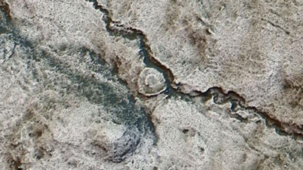
I am of course are speaking about the Isle of Arran in the Firth of Clyde where archaeologists from Historic Environment Scotland (HES) recently flew airborne laser scanning (lidar) devices over the land surface to generate a 3D image of prehistoric settlements, medieval farmsteads, and even a Neolithic monument, which the BBC called an “exceptionally rare find.”
The remains of a hut circle became clear from the LIDAR scanning results.
LIDAR and the Rise Of “Rapid” Archaeology
The lidar data is available from the Scottish Government Remote Sensing Portal and the survey results are available to view on Canmore – Scotland’s National Record of the Historic Environment. It was the largest survey of its type that has ever been conducted.
Dave Cowley, Rapid Archaeological Mapping Manager at Historic Environment Scotland ( HES) said it has shown scientists that there are “double” the number of ancient monuments on the Isle of Arran than they had previously known about and Scottish heritage leaders say “tens of thousands” of further sites might be found using the scanning technology.
Cowley also told reporters that the new 3D technology allowed for a “rapid” archaeological survey conducted over weeks rather than months or years, and it also allowed the discovery of sites that might even have been impossible to find.
Among the structures identified from the air are medieval and post-medieval shielings (circular stone structures which sheltered sheep from winds), which detail how upland areas were used by shepherds.
Post-medieval shielings were identified for the first time with LIDAR.
Furthermore, archaeologists identified a magnificent medieval roundhouse – a type of circular wooden home with a conical roof that was built in Britain from the Bronze Age throughout the Iron Age and into the medieval period .
Mesolithic Pitchstone Traders
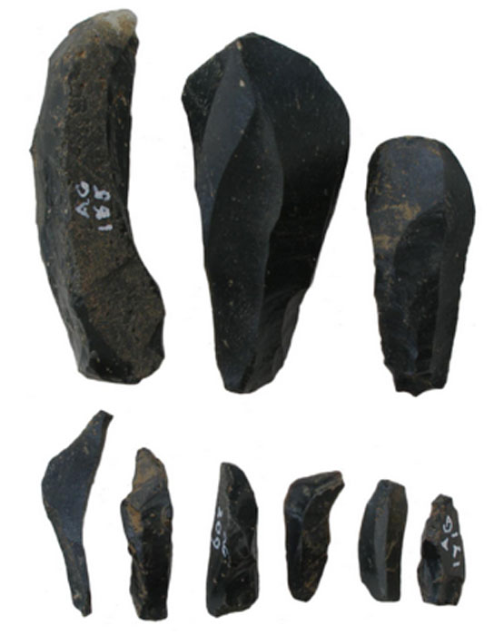
The Isle of Arran is the largest island in the Firth of Clyde and the seventh largest Scottish island . It is often referred to as a “geologist’s paradise,” and as far back as the Neolithic, and the Early Bronze Age, pitchstone from the Isle of Arran were transported around Britain.
According to a study published on Researchgate, worked Arran pitchstone from radiocarbon-dated pits indicate that on the Scottish mainland all archaeological pitchstone derives from outcrops on the Isle of Arran.
And on the island, pitchstone-bearing assemblages include diagnostic types from the Mesolithic that was traded extensively throughout Britain during the Early Neolithic period.
Pitchstone blades and microblades from Auchategan, Argyll & Bute
The Isle of Arran – An Ancient Spiritual Center
On Arran, archaeologists find a type of burial structure classified as a ‘Neolithic Clyde Cairn’ which are stone and earth mounds that enclose a chamber lined with larger stone slabs. They are thought to have been used for public community rituals.
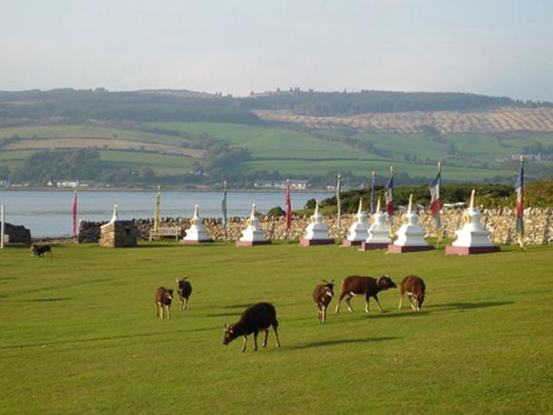
Several Bronze Age sites have been excavated and the monastery of Aileach was founded by St. Brendan in the 6th century with the nearby Holy Isle being a center of his spiritual activities. Holy Isle has a long history as a sacred site of pilgrimage with its healing holy well , 6th century monk St Molaise’s hermit cave, and a 13th-century monastery.
ome of the Soay sheep that live wild on Holy Isle in the Firth of Clyde, Scotland, are seen grazing by the Buddhist stupas which line the approach to the Centre for World Peace and Health.
Lidar technology is quickly building a new picture of Scotland’s historic environment and the new study on Arran is another step as the aerial scanning technology becomes more widely available.
And if the scientists’ speculations are right, and “ tens of thousands more ancient sites ” are discovered across the rest of Scotland, a whole new generation of archaeology, and archaeologists, will be attracted to the Highlands of Scotland.
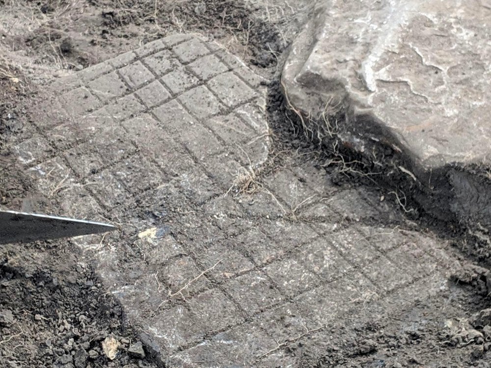
Archaeologists Uncover an Ancient Roman Game Board at Hadrian’s Wall
The cracked stone board was likely used to play ludus latrunculorum, Rome’s favorite game.
Life in the Roman legions is often presented as constant excitement, with endless military campaigns subduing people throughout Europe and the Near East. But the truth is Roman soldiers had down time.
The board was likely used in the bath house at Vindolanda, one of 14 forts along Hadrian’s Wall, but was repurposed as a floor stone in the adjacent building after it was broken.
As evidenced by a gridded gaming board recently uncovered during excavations of Hadrian’s Wall, a 73-mile-long fortification in what’s now northern England that once delineated the northern frontier of the Roman Empire, soldiers played games to pass the time.
Tony Henderson at Chronicle Live reports that the cracked stone game board was uncovered late last month while archaeologists excavated a third century building behind the bath house at Vindolanda, one of 14 forts along Hadrian’s Wall. It’s believed that the board was likely used in the bath house, but was repurposed as a floor stone in the adjacent building after it was broken.
It’s unknown how the board was cracked, but a spokesperson for the site tells Henderson it could be a colorful story. “You can almost picture the losing Roman tipping the board up in frustration, causing it to break,” he says.
This is not the only game board found at Vindolanda. Five other boards dating from the third to fifth centuries have been found along with glass and stone gaming tokens.
Construction of Hadrian’s Wall began in 122 A.D. at Roman emperor Hadrian’s behest and took six years to complete. It was the northernmost border of the Roman Empire until 138 A.D., when the emperor Antoninus Pius abandoned it and built a turf wall about 100 miles to the north.
Twenty years later, the Romans had to fall back to Hadrian’s Wall due to attacks by Caledonian tribes. The forts along Hadrian’s Wall were then occupied by Roman forces until around 400 A.D.
So what were soldiers on the frontier playing to pass the time? The grid on the stone is for a game called ludus latrunculorum, translated from Latin as “the game of mercenaries.” While archaeologists have found game boards and pieces at sites all across the Roman Empire, they have yet to figure out exactly how the game is played.
The website Ancient Games reports that ludus is first mentioned in the second century B.C. by the writer Varro who noted that it was a game played on a grid. A poem by an anonymous writer from the first century A.D. provides some details, including the fact that players captured each other’s pieces, moving backward and forward on the board.
Roman poet Ovid reveals that pieces were captured by surrounding an opposing piece with two game tokens. The game appears to be a more sophisticated variation of checkers, but we can only speculate on the official rules of the game.
That hasn’t prevented some game lovers from trying to develop rules from the little we know, and there are even some commercial versions available.
The game board is not the only recent news from Vindolanda, which has been excavated by the Vindolanda Trust since 1970. In that time, researchers have found thousands of artifacts from legionaries, including rare items made of wood and leather that have survived in the area’s mucky, oxygen-free soil.
Most famously, in 1973, archaeologists dug up hundreds of well-preserved wooden writing tablets that give insight into life at the camp for the average soldier as well as information on how the garrison was administered.
The notes include requests for commanders to send their soldiers more beer, a letter from one entrepreneurial civilian brother to another about making some cash off the soldiers, a birthday invitation and a request for a promotion, among other topics.
Last year, diggers found two sets of rare hipposandals, or iron objects used on the feet of horses, that recently went on display at the site’s Roman Army Museum. It’s not known if they are temporary horseshoes or some sort of restraint. They also found a strange, child-size bronze hand, which was likely part of a cult ritual.
There will undoubtedly be more cool finds, and maybe more game boards. Vindolanda researchers have only excavated about 25 percent of the site. At the current pace, it will take 150 years to unearth the entire area.
This 3,500-Year-Old Greek Tomb Upended What We Thought We Knew About the Roots of Western Civilization
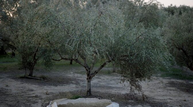
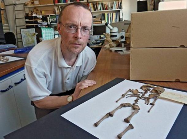
They had been digging for days, shaded from the Greek sun by a square of green tarpaulin slung between olive trees. The archaeologists used picks to break the cream-colored clay, baked as hard as rock, until what began as a cluster of stones just visible in the dirt became four walls in a neat rectangle, sinking down into the earth.
The warrior was buried in an olive grove outside the acropolis of Pylos. Though archaeologist Carl Blegen explored the olive grove in the 1960s, he did not find anything.
Little more than the occasional animal bone, however, came from the soil itself. On the morning of May 28, 2015, the sun gave way to an unseasonable drizzle. The pair digging that day, Flint Dibble and Alison Fields, waited for the rain to clear, then stepped down into their meter-deep hole and got to work. Dibble looked at Fields. “It’s got to be soon,” he said.
The season had not started well. The archaeologists were part of a group of close to three dozen researchers digging near the ancient Palace of Nestor, on a hilltop near Pylos on the southwest coast of Greece. The palace was built in the Bronze Age by the Mycenaeans—the heroes described in Homer’s epic poems—and was first excavated in the 1930s.
The dig’s leaders, Jack Davis and Sharon Stocker, husband-and-wife archaeologists from the University of Cincinnati, in Ohio, had hoped to excavate in a currant field just downslope from the palace, but Greek bureaucracy and a lawyers’ strike kept them from obtaining the necessary permits. So they settled, disappointed, on a neighboring olive grove.
They cleared the land of weeds and snakes and selected a few spots to investigate, including three stones that appeared to form a corner. As the trench around the stones sank deeper, the researchers allowed themselves to grow eager: The shaft’s dimensions, two meters by one meter, suggested a grave, and Mycenaean burials are famous for their breathtakingly rich contents, able to reveal volumes about the culture that produced them.
Still, there was no proof that this structure was even ancient, the archaeologists reminded themselves, and it might simply be a small cellar or shed.
Dibble was clearing earth from around a large stone slab when his pick hit something hard and the monotony of the clay was broken by a vivid flash of green: bronze.
The pair immediately put down their picks, and after placing an excited call to Davis and Stocker they began to carefully sweep up the soil and dust. They knew they were standing atop something substantial, but even then they did not imagine just how rich the discovery would turn out to be.“It was amazing,” says Stocker, a small woman in her 50s with dangling earrings and blue-gray eyes. “People had been walking across this field for three-and-a-half-thousand years.”
Yet remarkably little is known of the beginnings of Mycenaean culture. The Pylos grave, with its wealth of undisturbed burial objects and, at its bottom, a largely intact skeleton, offers a nearly unprecedented window into this time—and what it reveals is calling into question our most basic ideas about the roots of Western civilization.
Jack Davis and Sharon Stocker, husband-and-wife archaeologists from the University of Cincinnati, discovered the warrior’s grave.
In The Iliad, Homer tells of how Agamemnon, king of Mycenae, led a fleet of a thousand ships to besiege the city of Troy. Classical Greeks (and Romans, who traced their heritage to the Trojan hero Aeneas) accepted the stories in The Iliad and The Odyssey as a part of their national histories, but in later centuries scholars insisted that the epic battles fought between the Trojan and Mycenaean kingdoms were nothing more than myth and romantic fantasy. Before the eighth century B.C., archaeologists argued, societies on the Greek mainland were scattered and disorganized.
Today, Blegen’s work at Pylos is continued by Stocker and Davis (his official title is the Carl W. Blegen professor of Greek archaeology). Davis walks with me to the hilltop, and we pause to enjoy the gorgeous view of olive groves and cypress trees rolling down to a jewel-blue sea.
Davis has white-blond hair, freckles and a dry sense of humor, and he is steeped in the history of the place: Alongside Stocker, he has been working in this area for 25 years. As we look out to sea, he points out the island of Sphacteria, where the Athenians beat the Spartans during a fifth-century B.C. battle of the Peloponnesian War.
Behind us, Nestor’s palace is surrounded by flowering oleander trees and is covered with an impressive new metal roof, completed just in time for the site’s reopening to the public in June 2016 after a three-year, multimillion-euro restoration. The roof’s graceful white curves protect the ruins from the elements, while a raised walkway allows visitors to admire the floor plan.
The stone walls of the palace now rise just a meter from the ground, but it was originally a vast two-story complex, built around 1450 B.C., that covered more than 15,000 square feet and was visible for miles. Visitors would have passed through an open courtyard into a large throne room, Davis explains, with a central hearth for offerings and decorated with elaborately painted scenes including lions, griffins and a bard playing a lyre.
The Linear B tablets found by Blegen, deciphered in the 1950s, revealed that the palace was an administrative center that supported more than 50,000 people in an area covering all of modern-day Messenia in western Greece. Davis points out storerooms and pantries in which thousands of unused ceramic wine cups were found, as well as workshops for the production of leather and perfumed oils.
This era, extending until the construction of palaces at Pylos, Mycenae and elsewhere, is known to scholars as the “shaft grave period” (after the graves that Schliemann discovered). Cynthia Shelmerdine, a classicist and renowned scholar of Mycenaean society at the University of Texas at Austin, describes this period as “the moment the door opens.”
It is, she says, “the start of elites coming together to form something beyond just a minor chiefdom, the very beginning of what leads to the palatial civilization only a hundred years later.” From this first awakening, “it really takes a very short time for them to leap into full statehood and become great kings on a par with the Hittite emperor. It was a remarkable thing to happen.”
Yet partly as a result of the building of the palaces themselves, atop the razed mansions of early Mycenaeans, very little is known of the people and culture that gave birth to them. You can’t just tear up the plaster floors to see what’s underneath, Davis explains. The tholos itself went out of use around the time the palace was built. Whoever the first leaders here were, Davis and Stocker had assumed, they were buried in this plundered tomb. Until, less than a hundred yards from the tholos, the researchers found the warrior grave.
Aerial view of the warrior’s grave
The later site of 14th-century B.C. Nestor’s Palace
A bronze sword with a gold-coated hilt was among 1,500 items buried with Pylos’ “griffin warrior.”
Today known as Voidokilia, the omega-shaped cove at “sandy Pylos” is where Homer recounted that Telemachus, Odysseus’ son, was welcomed by Nestor while searching for his father.
Bull sacrifice was practiced by the Mycenaeans at Pylos, as recounted in The Odyssey. The autumn olive harvest is an ancient ritual that survives today.
The tholos tomb at Pylos
Davis and Stocker disagree on where they were when they received Dibble’s call from the dig site. Stocker remembers they were at the team’s workshop. Davis thinks they were at the local museum. Dibble recalls that they were in line at the bank. Whichever it was, they rushed to the site and, Stocker says, “basically never left.”
About a week in, Davis was excavating behind the stone slab. “I’ve found gold,” he said calmly. Stocker thought he was teasing, but he turned around with a golden bead in his palm. It was the first in a flood of small, precious items: beads; a tiny gold birdcage pendant; intricately carved gold rings; and several gold and silver cups.
“Then things changed,” says Stocker. Aware of the high risk of looting, she organized round-the-clock security, and, apart from the Ministry of Culture and the site’s head guard, the archaeologists agreed to tell no one about the more valuable finds. They excavated in pairs, always with one person on watch, ready to cover precious items if someone approached.
The largest ring discovered was made of multiple finely soldered gold sheets.
And yet it was impossible not to feel elated, too. “There were days when 150 beads were coming out—gold, amethyst, carnelian,” says Davis. “There were days when there was one seal stone after another, with beautiful images. It was like, Oh my god, what will come next?!” Beyond the pure thrill of uncovering such exquisite items, the researchers knew that the complex finds represented an unprecedented opportunity to piece together this moment in history, promising insights into everything from religious iconography to local manufacturing techniques.
The discovery of a golden cup, as lovely as the day it was made, proved an emotional moment. “How could you not be moved?” says Stocker. “It’s the passion of looking at a beautiful piece of art or listening to a piece of music. There’s a human element. If you forget that, it becomes an exercise in removing things from the ground.”
Fragments of Ancient Life
From jewelry to gilded weapons, a sampling of the buried artifacts researchers are using to fill in the details about the social currents in Greece at the time the griffin warrior lived
Like any momentous archaeological find, the griffin warrior’s grave has two stories to tell. One is the individual story of this man—who he was, when he lived, what role he played in local events. The other story is broader—what he tells us about the larger world and the crucial shifts in power taking place at that moment in history.
Analyses of the skeleton show that this 30-something dignitary stood around five-and-a-half feet, tall for a man of his time. Combs found in the grave imply that he had long hair. And a recent computerized facial reconstruction based on the warrior’s skull, created by Lynne Schepartz and Tobias Houlton, physical anthropologists at the University of the Witwatersrand in Johannesburg, shows a broad, determined face with close-set eyes and a prominent jaw. Davis and Stocker are also planning DNA tests and isotope analyses that they hope will provide information about his ethnic and geographic origins.
And this has been the scholarly consensus ever since: The Mycenaeans, now thought to have sacked Knossos at around the time they built their mainland palaces and established their language and administrative system on Crete, were the true ancestors of Europe.
Significantly, weapons had been placed on the left side of the warrior’s body while rings and seal stones were on the right, suggesting that they were arranged with intent, not simply thrown in. The representational artwork featured on the rings also had direct connections to actual buried objects.
“One of the gold rings has a goddess standing on top of a mountain with a staff that seems to be crowned by a horned bull’s head,” says Davis. “We found a bull’s head staff in the grave.” Another ring shows a goddess sitting on a throne, looking at herself in the mirror. “We have a mirror.” Davis and Stocker do not believe that all this is a coincidence. “We think that objects were chosen to interact with the iconography of the rings.”
Horns, which symbolize authority, appear on this bronze bull’s head and three gold rings.
In their view, the arrangement of objects in the grave provides the first real evidence that the mainland elite were experts in Minoan ideas and customs, who understood very well the symbolic meaning of the products they acquired. “The grave shows these are not just knuckle-scraping, Neanderthal Mycenaeans who were completely bowled over by the very existence of Minoan culture,” says Bennet. “They know what these objects are.”
“I think we should all care about that,” says Shelmerdine. “It resonates today, when you have factions that want to throw everybody out [of their countries]. I don’t think the Mycenaeans would have gotten anywhere if they hadn’t been able to reach beyond their shores.”
9,000-yr-old Site near Jerusalem is the “Big Bang” of Prehistory Settlement
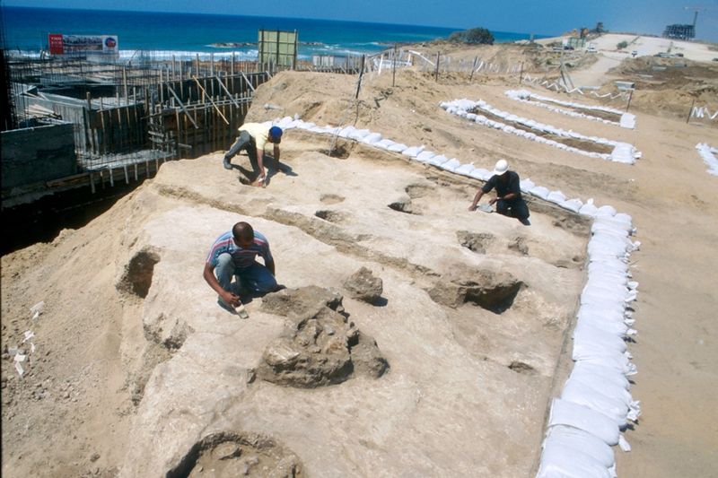
A huge 9,000-year-old Neolithic settlement — the largest ever discovered in Israel, say archaeologists — is currently being excavated outside Jerusalem, researchers said in mid 2019.
This site, located near the town of Motza, is the “Big Bang” for prehistory settlement research due to its size and the preservation of its material culture, said Jacob Vardi, co-director of the excavations at Motza on behalf of the Antiquities Authority, according to The Times of Israel.
Among the many important findings is that 9,000 years ago, the people of the settlement practiced religion. “They carried out rituals and honored their deceased ancestors,” Vardi, an archaeologist, told Religion News Service.
Dwelling foundations unearthed at Tell es-Sultan in Jericho
Perhaps 3,000 people lived in this settlement near where Jerusalem is today, making it quite a large city for the period that is sometimes called the New Stone Age. The site has “yielded thousands of tools and ornaments, including arrowheads, figurines and jewelry,” said CNN.”
The findings also provide evidence of sophisticated urban planning and farming, which may force experts to rethink the region’s early history, said archeologists involved in the excavation.”
Although the area has long been of archeological interest, Vardi said the sheer scale of the site — which measures between 30 and 40 hectares — only emerged in 2015 during surveys for a proposed highway.
Ashkelon Pre-Pottery Neolithic C site.
“It’s a game changer, a site that will drastically shift what we know about the Neolithic era,” said Vardi in an interview with The Times of Israel. Already some international scholars are beginning to realize the existence of the site may necessitate revisions to their work, he said.
“So far, it was believed that the Judea area was empty, and that sites of that size existed only on the other bank of the Jordan river, or in the Northern Levant. Instead of an uninhabited area from that period, we have found a complex site, where varied economic means of subsistence existed, and all this only several dozens of centimeters below the surface,” according to Vardi and co-director Dr. Hamoudi Khalaily in an IAA press release.
Israelite Temple at Tel Motza.
This site predates the first known settlement in Jerusalem by about 3,500 years. Experts had not thought that people lived in such a concentrated fashion during this time in the region.
During the 16-month excavation, archaeologists discovered large buildings, separated by well-planned alleys, used for residential and public purposes. Some of the buildings contained plaster remnants.
Archaeological excavations near Motza, Israel.
Pieces of jewelry, including bracelets made of stone and mother of pearl, as well as figurines, locally made flint axes, sickle blades, knives, and thousands of arrowheads were also unearthed, said Religion News.
Vardi said the residents buried their dead with care in designated burial locations and placed “either useful or precious objects, believed to serve the deceased” after they died, inside the graves.
“We have decorated burial sites, with offerings, and we also found statuettes and figurines, which indicate they had some sort of belief, faith, rituals,” Vardi said. “We also found certain installations, special niches that might have played a role in ritual.”
Sheds held a large number of well-preserved legume seeds, something the archaeologists called “astonishing” given how much time has passed.
“This finding is evidence of an intensive practice of agriculture. Moreover, one can conclude from it that the Neolithic Revolution reached its summit at that point: animal bones found on the site show that the settlement’s residents became increasingly specialized in sheep-keeping, while the use of hunting for survival gradually decreased,” the antiquities authority said.
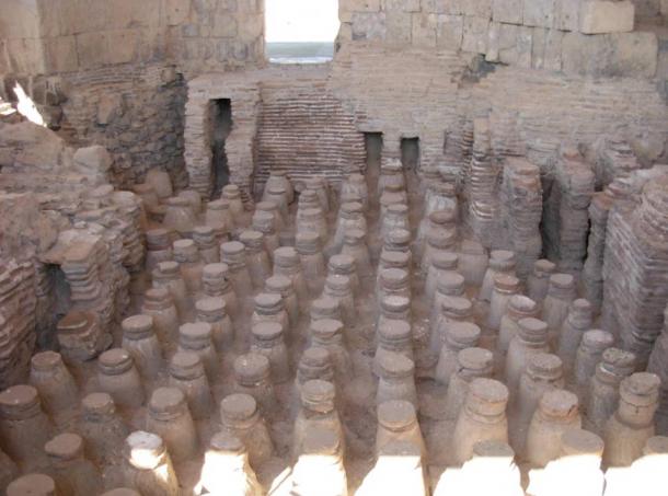
The discovery of a mass baby grave under a Roman bathhouse in Ashkelon, Israel
In the seaport of Ashkelon, along the coast of the Israeli Mediterranean coast, archaeologist Ross Voss made a bizarre discovery, while exploring one of the sewers of the area, he found a significant amount of bones. At first, the bones were accepted to be chicken bones. Later, it was found that the bones were that of human.
Remains of Roman bathhouse in Israel
Newborn child bones from the Roman period. With the remaining parts adding up to in excess of 100 children, it was the biggest disclosure of babies remains to date.
Why were these roman babies killed?
As curious as you are, so was the Archaeologist while he found out the bones of the newborns. Voss took the remaining parts to forensic anthropologist Professor Patrician Smith. Smith analyzed the baby remains and established that there was no indication of the chances of survival of the babies longer than a week before being killed.
She used a technique of forensic testing that enabled her to confirm that none of the newborn children was healthy when they died.
During the era of Romans, it was normal for babies to be murdered as a type of birth control. It wasn’t a crime, as babies were seen as being ‘not completely human.
As a rule, a Roman lady who did not need an infant would take part in the act of “exposure” as she would desert the newborn child, either to be found and taken care of by another person or to die.
As per the convictions at the time, it was up to the gods to decide if the newborn child would be saved or not.
According to Roman mythology, the most popular record of close child murder, in which Romulus and Remus, two newborn children of the war god, Mars, were surrendered in the forested areas yet were raised by wolves and later established the city of Rome.
The most famous account of attempted infanticide, in which babies were left exposed to the elements, is the story of Romulus and Remus
Research showed that the newborn children at Ashkelon did not seem to have been “exposed”. Rather, it shows up they were deliberately murdered. One piece of information into the purpose behind their murder lies in the area of the bodies.
Investigations uncovered that the sewer where the remaining parts were found was straight underneath a previous bathhouse. It is conceivable that the babies were born to prostitutes or workers who worked at the bathhouse. However, this remains a mystery as there is no additional information on this theory.
While Ashkelon bathhouse was not the only place the bodies of the Roman infants were found.
Hambleden(the site of a former Roman villa) mass killing
In 1912, Alfred Heneage Cocks, the guardian of the Buckinghamshire County Museum in England, made a stunning disclosure. While driving an unearthing in Hambleden, Cocks revealed the remains of 103 people.
Of those 103 people, 97 were newborn children, 3 were children, and 3 were adults. While this frightful find delivers inquiries of how and why these babies had been slaughtered, Cocks neglected to conduct any further examination with regards to the roots of the bodies.
Hambleden – site of mass baby grave, Buckinghamshire, England.
Jill Eyers, archaeologist and director of Chiltern Archeology in England, found the remaining in a historical centre file, the bones spent near a century in 35 little boxes intended to hold free cigarettes and shotgun cartridges, each container sufficiently enormous to hold the total skeleton of one baby.
“It was quite heart-rending, really, to open all these little cigarette boxes and find babies inside,” said Eyers.
Then he chose to look into the reason for the mass killing. People believed that the Hambleden site is another area where prostitutes would give birth to an unwanted child that was consequently murdered. The site was not a region of poverty, so an absence of resource couldn’t clarify the mass executing.
There were additionally no recorded diseases in the region at the time that could represent the huge volume of death. People believe that the main sensible clarification is that the site once housed a brothel.
Because of the absence of birth control at that time, there were restricted choices for the who needed to abstain from having a baby or bringing up the child. So, child murder may have been the main decision they trusted they had.
Dr Simon Mays, a skeletal biologist at English Heritage, has examined the Hambleden Roman infant bones
However, the reasons for the death may be any, but the mass graves of newborn child remains are genuinely heartbreaking. The history behind the roman era living is a big mystery. In time, it is trusted that we may discover more responses to precisely how and why these newborns were killed.
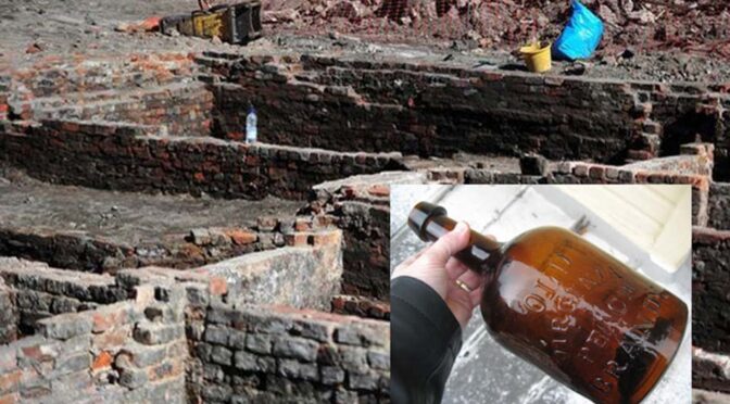
Intact Brandy Bottles and 200-Year-Old Pub Discovered Under Building Site in Manchester
An unexpected discovery was made when works began for a 13-storey skyscraper for apartments and shops in Manchester, England. Archaeologists brought in to the construction site found the remains of a forgotten 200-year-old pub and neighboring houses.
The Manchester Evening News reports that the archaeologists even know the name of the old pub- the Astley Arms. One of the interesting finds they made inside the rubble is the discovery of about 200-year-old booze bottles.
Some of the bottles still contain brandy. James Alderson, site developer of Mulbury City which is carrying out the build, told the Manchester Evening News “We opened the cork on a few and you can still smell it.
It’s amazing knowing there’s so much history at this site and it’s really exciting. I never expected this kind of thing to be found but we are really fascinated by it all.”
The archaeologists were also able to find the name of the Astley Arm’s 1821 owner, Thomas Evans, on some personalized plates. Aidan Turner, supervisor at the site and senior archaeologist, told the Manchester Evening News that the team managed to track down descendants of the pub’s owner. He said that they discovered one living relative is now living in Texas, USA.
It was found that the Astley Arms had its name changed in 1840. Then owner, Thomas Inglesent, called the pub the Paganini Tavern. However, the name returned to Astley Arms in the 1850s. Historians say that part of the building was rebuilt in 1986, but it was demolished later on.
Keys, pots for quills, and pipes were amongst other artifacts found at the site. The pottery has been dated to the early 1800s and at least some of the bottles are from the late 1900s.
All of these everyday items have a special value for the archaeologists. As Turner said “It’s brilliant because you can suddenly connect it to the local people in the area. It’s nice to be able to connect it directly to living people and their families.”
Alderson added “Part of Manchester’s vast history is being captured in these findings which is really interesting. It really takes you back to the time when they would have been outside of the pub drinking.”
The Manchester Evening News reports that some of the artifacts that have been discovered at the site will be displayed in the future at the Museum of Science and Industry.
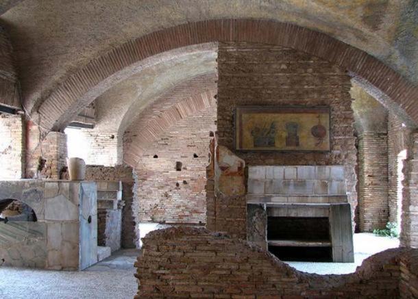
A Pompeiian taberna for eating and drinking. The faded painting over the counter pictured eggs, olives, fruit and radishes.
The Roman tavern is also said to have served “as an invaluable indicator of the changing social and economic infrastructure of the settlement and its inhabitants following the Roman conquest of Mediterranean Gaul in the late second century B.C.”
Before the Romans’ arrived in the ancient town, called Lattara, it was an area made up of farmers. The Roman presence created a more diverse economy, and the need for places to eat outside the home.
Two ancient skeletons found holding hands in medieval chapel
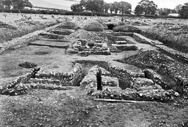
Archaeologists have discovered two skeletons holding hands at an ancient site of pilgrimage, in the newly-discovered Chapel of St Morrell in Leicestershire England.
According to a news release in the Leicester Mercury , the remains are that of a man and a woman of a similar age, although researchers are not sure of their identity.
The medieval Chapel of St Morrell was only recently rediscovered after it had become long lost to the pages of history. However, local historian John Morrison, was able to track down its location through researching old historical records, and geophysicists were then called in to take images of the land to locate the exact spot to begin digging. Excavations at the site have now been ongoing for the last four years.
Volunteers Lotty Wallace and Ken Wallace work on a small section of the excavation.
Old records refer to the chapel as being dedicated to Saint Morrell, the 4th Bishop of Anjou, France, who lived in the 5 th century AD.
The earliest mention of the chapel was in a will of 1532, and in 1622, a writer notes that multitudes travelled to the chapel to be healed. However, archaeological remains at the site go back as early as the Roman period, some 2,000 years ago.
“This ground has been used as a special sort of place by people for at least 2,000 years,” said archaeologist Vicky Score, of the University of Leicester, who is leading the project.
Along with the two skeletons holding hands, researchers also found seven other sets of remains dating back to the 14 th century AD, each ‘held down’ by a large stone placed on top of their bodies.
“This was a tradition popular in eastern Europe with the idea of keeping the dead down,” said Score.
It is not the first time that archaeologists have unearthed couples holding hands in death. In 2011, archaeologists found the skeletal remains of a Roman-era couple holding hands in a tomb located in Modena, Italy; in 2012, dozens of tombs uncovered in Siberia contained the skeletal remains of couples in loving embrace ; and in 2013, researchers discovered the remains of a medieval couple holding hands in a former Dominican monastery in Cluj-Napoca, Romania.
“Whoever buried these people likely felt that communicating their relationship was just as important in death as it was in life,” said Kristina Killgrove, a biological anthropologist at the University of North Carolina, who was involved in the Modena finding.
The skeletal remains of a young couple found in a former Dominican monastery in Cluj-Napoca, Romania.
The discovery of skeletons holding hands has often perplexed researchers, who have questioned how they came to die at around the same time.
While the first assumption usually made is that one died and then the other committed suicide, this is unlikely because suicide was regarded as a sin in the Medieval Ages, so anyone who killed themselves would not have been buried in a holy place.
Such findings shine a light on the humanity behind ancient discoveries and lead us to wonder about who they were, how they died, and what their lives may have been like.
Archaeologist Donato Labate, the director of the excavation in Modena, Italy, said that the discovery evokes an uplifting tenderness. “I have been involved in many digs, but I’ve never felt so moved.”
5,000-year-old wooden boat used by the pharaohs is discovered by French archaeologists
French archaeologists have discovered a 5,000-year-old wooden boat in an expedition in Egypt, it has emerged.
The significant discovery was made in Abu Rawash, west of Cairo, the antiquities ministry in Egypt said.
Mohammed Ibrahim, the antiquities minister, said: ‘It goes back to the era of Pharaoh Den, one of the First Dynasty kings’.
French archaeologists have discovered a 5,000-year-old pharaonic solar boat in an expedition in Egypt, it has emerged
The six-metre long and 1.5-metre wide pharaonic solar boat ‘is in good condition,’ he added.
Its planks are now undergoing renovation before it is put on display in a museum.
The pharaohs believed that solar boats, buried close to them at death, would transport them in the afterlife.
According to Middle East Online, the boat’s wooden sheets were transported to the planned National Museum of Egyptiamn Civilisation were they will be restored.
One the museum is finished, it is expected they will be put on display at some point next year.
The group of French archeologists were working for the French Institute of Oriental Archaeology (IFAO).
The discovery was made in Abu Rawash, west of Cairo
An archaeologist is seen working on the skeleton of the newly discovered wooden boat. The pharaohs believed that solar boats, buried close to them at death, would transport them in the afterlife
The group first started its excavation work in Abu Rawash in the early 1900s.
In 1954 an Egyptian archaeologist discovered what may be the Pharaoh Khufu’s 43-metre solar ship, made of cedar, in a Giza pyramid.
The 4,500 year-old intact vessel is on display near the pyramid.
It is one of the oldest, largest, and best-preserved vessels from antiquity and has been identified as the world’s oldest intact ship.
It is known as a ‘solar barge’, a ritual vessel to carry the resurrected king with the sun god Ra across the heavens.
Tollund Man – the preserved face from Prehistoric Denmark and the tale of ritual sacrifice
Tollund Man is the naturally mummified body of a man who lived during the 4th century BC, during the period characterised in Scandinavia as the Pre-Roman Iron Age. He was hanged as a sacrifice to the gods and placed in a peat bog where he remained preserved for more than two millennia.
The face of the Tollund Man is as preserved as the day he died. The look upon his face is calm and peaceful, as though looking upon a sleeping man.
It was 6 th May, 1950, when two brothers cutting peat in the Bjaeldskov bog, an area about 10 kilometres west of the Danish town of Silkeborg, came upon the lifeless body of a man. The man’s physical features were so well-preserved that he was mistaken at the time of discovery for a recent murder victim and the police were called.
Puzzled by the appearance of the remains and recalling the discovery of two other ‘bog bodies’ in the same bog in 1927 and 1938, the police asked an archaeologist named P. V.
Glob to come and view the discovery. Recognizing that this was an ancient burial, Glob began efforts to remove the body for further study.
The examination of the Tollund Man at the National Museum of Denmark in 1950 revealed an unusually well-preserved body of an adult male who was slightly over five feet tall and approximately 40 years old when he died.
The stubble on his chain, eyelashes, and the wrinkles in his skin can still be observed in minute detail. His last meal was porridge made from 40 different kinds of seeds and grains.
Head of Tollund Man on the left and a restoration image on the right
Tollund Man was naked apart from a leather cap and a wide belt around his waist. Around his neck was a braided leather rope tightened in a noose.
It was clear that he had been hanged – but why? Was he a criminal, a victim of crime, or part of a ritual sacrifice? Archaeologists embarked on an investigation to find out.
The Tollund Man as he appears today.
Like all the other ‘bog bodies’ that have been found, Tollund Man showed no signs of injury or trauma, apart from that caused by the hanging. It was clear that he had also been buried carefully in the bog – his eyes and mouth had been closed and his body placed in a sleeping position – something that wouldn’t have happened if he were a common criminal.
When somebody died in the Iron Age, the body was cremated in a funeral pyre and the ashes placed in an urn, but Tolland Man was buried in a watery place where the early people of Europe believed they could communicate with their many gods and goddesses. He was also killed in the winter or early spring, a time that human sacrifices were made to the goddess of spring.
Taking into account all of these factors, archaeologists believe that Tollund Man was ritually sacrificed. He may have been an offering to the gods in return for peat that was taken from the bog.
The incredible discovery of Tollund Man has brought to life in vivid detail the lives and deaths of the people of prehistoric Denmark. He now resides in a special room of the Silkeborg Museum.
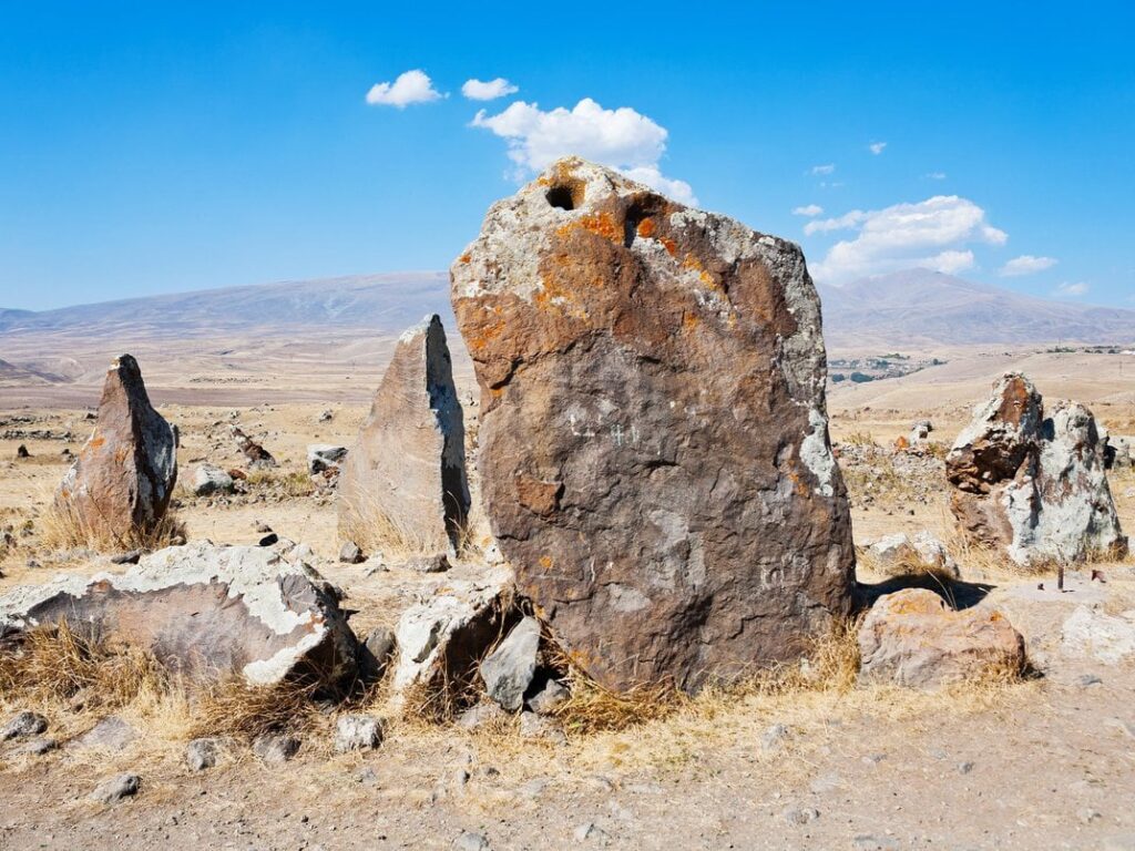
Unraveling the Mystery of the “Armenian Stonehenge”
The misty and mountainous valleys of the south Caucasus have been host to human activity continuously for thousands of years, but only recently has the Western archaeological world had access to them.
From the cave in which researchers found the world’s oldest shoe and the oldest winemaking facility, to traces of an Urartian city with hundreds of wine-holding vessels buried in the ground, the last four decades have witnessed extraordinary interest from scholars and tourists alike in the smallest republic in the former Soviet Union. None, however, are as quite as tantalizing as the 4.5 hectare archaeological site whose name is as contested as its mysterious origins.
Helicopter image of Karahundj
Located in Armenia’s southernmost province, Zorats Karer, or as it is vernacularly known, Karahundj, is a site which has been inhabited numerous times across millennia, from prehistoric to medieval civilizations.
It consists of a prehistoric mausoleum and nearby, over two hundred neighboring large stone monoliths, eighty of which have distinctive, well-polished holes bored near their upper edge.
In recent years, to the dismay of local scientists, the monoliths have garnered the interest of the international community after some pre-emptive research emerged drawing comparisons between the astronomical implications of Zorats Karer and that of the famous Stonehenge monument in England.
Many touristic outlets responded to the comparison by branding Zorats Karer colloquially as the ‘Armenian Stonehenge’ and the resulting debate between the scientific community and popular culture has been a fierce one.
The first scholarly account of Zorats Karer took place in 1935 by ethnographer Stepan Lisitsian, who alleged that it once functioned as a station for holding animals. Later, in the 1950s, Marus Hasratyan discovered a set of 11th to 9th century BCE burial chambers.
But the first investigation which garnered international attention to the complex was that of Soviet archaeologist Onnik Khnkikyan, who claimed in 1984 that the 223 megalithic stones in the complex may have been used, not for animal husbandry, but instead for prehistoric stargazing.
He believed the holes on the stones, which are two inches in diameter and run up to twenty inches deep, may have been used as early telescopes for looking out into the distance or at the sky.
Intrigued by the astronomical implications, the next series of investigations were conducted by an astrophysicist named Elma Parsamian from the Byurakan Astrophysical Observatory, one of the main astronomy centers of the USSR.
She and her colleagues observed the position of the holes according to an astronomical calendar and established that several of them aligned with the sunrise and sunset on the day of the summer solstice.
Image of Karahundj at Sunset, from Elma Parsamian’s investigations in 1984
She is also responsible for suggesting the name Karahundj for the site, after a village 40km away by the same name. Prior to her investigations, locals referred to the site as Ghoshun Dash, which meant ‘Army of Stones’ in Turkic.
Folk myth suggests the stones were erected in ancient times to commemorate soldiers killed in war. After the 1930s, locals transitioned to the Armenian translation, Zorats Karer. But Karahundj, Parsamian said, offered a more interesting name because Kar, means stone and hundj, a peculiar suffix which has no meaning in Armenian, sounds remarkably similar to the British ‘henge’.
In recent years, this name has received extreme criticism from scholars and in scientific texts, the name Zorats Karer is used nearly exclusively.
Several years later, a radiophysicist named Paris Herouni performed a series of amateur studies branching off from Parsamian’s, using telescopic methods and the precession laws of Earth. He argued that the site actually dates back to around 5500 BCE., predating its British counterpart by over four thousand years.
He strongly pioneered for a direct comparison to Stonehenge and even went so far as to etymologically trace the name Stonehenge to the word Karahundj, claiming it really had Armenian origins. He was also in correspondence with the leading scholar of the Stonehenge observatory theory, Gerald Hawkins, who approved of his work. His claims were quick to catch on, and other scholars who strongly contest his finding have found them difficult to dispel.
A figure from Herouni’s book Armenians and Old Armenia where he points out this group of stones as an astronomical tool.
The problem with the “Armenian Stonehenge” label, notes archaeo-astronomer Clive Ruggles in Ancient Astronomy: An Encyclopedia of Cosmologies and Myth, is that analyses that identify Stonehenge as an ancient observatory have today largely been dispelled. As a result, he says, the research drawing comparisons between the two sites is “less than helpful.”
According to Professor Pavel Avetisyan, an archaeologist at the National Academy of Sciences in Armenia, there is no scientific dispute about the monument. “Experts have a clear understanding of the area,” he says, “and believe that it is a multi-layered [multi-use] monument, which requires long-term excavation and study.”
In 2000, he helped lead a team of German researchers from University of Munich in investigating the site. In their findings, they, too, criticized the observatory hypothesis, writing, “… [A]n exact investigation of the place yields other results. [Zora Karer], located on a rocky promontory, was mainly a necropolis from the Middle Bronze Age to the Iron Age. Enormous stone tombs of these periods can be found within the area.” Avetisyan’s team dates the monument to no older than 2000 BCE, after Stonehenge, and also suggested the possibility that the place served as a refuge during times of war in the Hellenistic period.
“The view that the monument is an ancient observatory or that its name is Karahundj is elementary charlatanism, and nothing else. All of that,” says Avetisian, “has nothing to do with science.”
Unfortunately for Avetisyan, dispelling myths about Zorats Karer is difficult when so few resources exist in English to aid the curious Westerner. Richard Ney, an American who moved to Armenia in 1992, founded the Armenian Monuments Awareness Project and authored the first English-language resource to the site from 1997, has witnessed over two decades of back-and-forth.
He believes Karahundj is “caught between two different branches of science with opposing views on how to derive fact. Both are credible,” he says, “and I feel both can be correct, but will never admit it.”
Despite all the controversy and whatever you end up deciding to call it, the monument itself is stunning and located in an area of Armenia well-endowed with natural beauty, making it an attractive journey for many tourists each year.
It’s even become an object of contemporary interest to young urbanites and neo-Pagans from Yerevan, who are known to celebrate certain solstices there. In many ways, Zorats Karer is a testament to the elusive nature of archaeology, and it’s perhaps the case that the mystery is–and will remain–part of its appeal.