Category Archives: U.S.A

Ancient Alutiiq Weavings: Uncovering 3,000-Year-Old Artifacts in Alaska

Ancient Alutiiq Weavings: Uncovering 3,000-Year-Old Artifacts in Alaska


During excavations of an ancestral sod house on the shore of Karluk Lake, Kodiak Island, Alaska, archaeologists uncovered rare fragments of woven grass artifacts estimated to be 3,000 years old.

The fragments, which appear to be pieces of mats, are the oldest well-documented examples of Kodiak Alutiiq/Sugpiaq weaving.

“We were excavating a sod house beside Karluk Lake as part of a broader study to understand how Alutiiq people used Kodiak’sinterior,” said Saltonstall. “When we reached the floor, we discovered that the house had burned and collapsed.

The walls of the structure, which were lined with wood, fell into the building and covered a portion of the floor. This sealed the floor quickly and limited burning. As we removed the remains of the walls, we were surprised and excited to find fragments of charred weaving.

Weaving is a long-practiced Alutiiq art

It looks like the house had grass mats on the floor. The pieces covered about a two-meter area at the back of the house, perhaps in an area for sleeping,” Alutiiq Museum Curator of Archaeology Patrick Saltonstall explained in a press release.

Weaving is a long-practiced Alutiiq art, but one that is difficult to document archaeologically as fiber artifacts are fragile and rarely preserved.

The Alutiiq Museum’s extensive archaeological collections contain grass and spruce root baskets that are as much as 600 years old but nothing older.

The house that produced the weavings was radiocarbon-dated to about 3,000 years old. The style of the structure and artifacts found in association support this determination.

Detail of ca. 3,000-year-old grass matting from ancestral Alutiiq house by Karluk Lake

“Our ancestors likely worked with plant fibers for millennia, from the time they arrived on Kodiak 7500 years ago,” said April Laktonen Counceller, the museum’s executive director.

“It makes sense. Plants are abundant and easily harvested, and they are excellent materials for making containers, mats, and other useful items. It’s just very hard to document this practice. This wonderful find extends our knowledge of Alutiiq weaving back an additional 2400 years.”

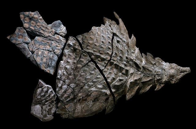
Close inspection of the woven fragments shows that their makers laid down long parallel strands of grass (the warp) and then secured them with perpendicular rows of twining (the weft)spaced about an inch apart.

This technique created an open weave, also found in historic examples of Alutiiq grass matting. Small fragments of more complicated braiding may represent the finished edge of a mat.

The field crew carefully lifted the fragile woven fragments off the floor of the sod house and placed them in a specially made box for transport back to Kodiak and the Alutiiq Museum’slaboratory.

Here, they will be preserved, documented, and made available for study as a loan from Koniag—the regional Alaska Native Corporation for Kodiak Alutiiq people and the sponsor of the research. The corporation owns the land on which the excavation took and has been generously supporting archaeological studies in the region.

“Discoveries like these highlight our Alutiiq people’s innovation and resilience,” said Koniag President Shauna Hegna.“Koniag is humbled to partner with the Alutiiq Museum on critical projects like this.”

California Gold Mine Reveals 40 Million-Year-Old Tools Were Found

California Gold Mine Reveals 40 Million-Year-Old Tools Were Found


At Table Mountain and other locations in the gold mining region around the middle of the nineteenth century, miners discovered hundreds of stone artifacts and human bones buried deep inside their tunnels. Experts claim that these bones and artifacts were found embedded in layers from the Eocene epoch (38-55 million years).

The Auriferous Gravels of the Sierra Nevada of California, written by Dr. J. D. Whitney, the leading government geologist in California, was published in 1880 by Harvard University’s Peabody Museum of Comparative Zoology.

However, because the information went against accepted Darwinist theories on human origins, it was excluded from scholarly discussions. In 1849, gold was found in the gravels of old riverbeds on the slopes of the Sierra Nevada Mountains, drawing large numbers of rowdy adventurers to settlements including Brandy City, Last Chance, Lost Camp, You Bet, and Poker Flat.

Initially, solitary miners searched for flakes and nuggets among the gravel that had made their way into the present-day streambeds. Auriferous (gold-bearing) gravels were quickly washed from hillsides by high-pressure water jets while other gold-mining businesses bored holes into mountainside deposits and followed the gravel deposits wherever they led.

The miners found hundreds of stone items as well as human fossils. The scientific community received the most crucial information from Dr. J. D. Whitney.

Artifacts from hydraulic mining and surface deposits were of questionable age, while deep mine shaft and tunnel artifacts could be more accurately dated. According to J. D. Whitney, the geological evidence revealed that the auriferous gravels were at least Pliocene in age.

However, according to modern geologists, some of the gravel layers are Eocene in origin. In Tuolumne County’s Table Mountain, several holes were dug, traveling through thick strata of latite, a basaltic volcanic substance, before arriving at the gravels containing gold.

In other instances, the tunnels stretched hundreds of feet horizontally beneath the latite top. The age of findings from the gravels directly above the bedrock might be between 33.2 and 55 million years old, and those from other gravels could be between 9 and 55 million years old.

According to William B. Holmes, a physical anthropologist at the Smithsonian Institution, “If Professor Whitney had fully appreciated the story of human evolution as it is understood today, he would have hesitated to announce the conclusions formulated, notwithstanding the imposing array of testimony with which he was confronted.” Or, to put it another way, the theory had to be rejected if the evidence did not support it, which is exactly what happened.

The Phoebe Hearst Museum of Anthropology at the University of California, Berkeley, still has some of the items Whitney mentioned on the exhibit. Darwinism and other isms affected how archaeological evidence was handled in Hueyatlaco, Mexico.

Archaeologists working under the direction of Cynthia Irwin-Williams found stone tools there in the 1970s that were associated with bones from butchered animals.

A group of geologists, including Virginia Steen-McIntyre, dated the location. The age of the site was established using four different techniques: stratigraphic analysis, zircon fission track dating on volcanic layers above the artifact layers, tephra hydration dating of volcanic crystals found in volcanic layers above the artifact layers, and uranium-series dates on butchered animal bones.

The reason the archaeologists were hesitant to put an age on the site was because they thought that (1) no humans were around 250,000 years ago anyplace on the earth, and (2) no humans visited North America until at most 15,000 or 20,000 years ago.

At Table Mountain and other locations in the gold mining region around the middle of the nineteenth century, miners discovered hundreds of stone artifacts and human bones buried deep inside their tunnels.

This Ancient Underground City Was Big Enough to House 20,000 People

This Ancient Underground City Was Big Enough to House 20,000 People


Chicago, like a lot of other modern cities, has a hidden secret: It’s home to miles of passageways deep underground that allow commuters to get from one place to another without risking nasty weather.

Los Angeles, Boston, New York, and Dallas all have their own networks of underground tunnels, as well. But there’s a place in Eastern Europe that puts those forgotten passages to shame. Welcome to Derinkuyu — the underground city.

The Cappadocia landscape with its tuff towers.

A Subterranean Suburb

Picture this. It’s 1963, and you’re on a construction crew renovating a home. You bring your sledgehammer down on a soft stone wall, and it all crumbles away, revealing a large, snaking passageway so long that you can’t see where it ends.

This is the true story of how the undercity at Derinkuyu was (re-)discovered. While those workers knew they’d found something special, they couldn’t know just how massive their discovery had been.

Circular stones were used to seal access to passageways.

Stretching 250 feet (76 meters) underground with at least 18 distinct levels, Derinkuyu was a truly massive place to live. Yes, live. There was room for 20,000 people to stay here, complete with all of the necessities (and a few luxuries) — freshwater, stables, places of worship, and even wineries and oil presses.

It isn’t the only underground city in the area known as Cappadocia, but it’s the deepest one we know of, and for many years, it was believed to be the largest as well. (Another recently discovered location may have been home to even more people.)

Derinkuyu and the other 40-ish underground cities nearby are made possible thanks to the prevalence of tuff in the area, a kind of volcanic rock that solidifies into something soft and crumbly. That makes it relatively easy to carve enormous subterranean passages — but why would you want to? The answer lies in the cities’ origins.

Defense Against the Sword Arts

Derinkuyu isn’t exactly inhospitable on the surface level (after all, that’s where the people who found it were living). So why did ancient people decide to build their living quarters below the surface? Because they weren’t hiding from the broiling sun or annual meteor showers.

They were clearly hiding from invading forces, with massive, rolling stone doors to block off each floor should any armies breach the fortress. But who were the people of the caves, and who were they defending themselves against? The answer to the second question depends on the answer to the first.

The earliest known people to live in the area were the Hittites, who ruled the Turkish Peninsula from about the 17th to 13th centuries B.C.E. — well over three millennia ago.

A 55-meter (180-ft) shaft used a primary well at Derinkuyu.

Some scholars point to artifacts with Hittite cultural elements, such as a small statue of a lion, found in the underground caves. That suggests these ancient people would have been taking refuge from invading Thracians.

If they were, it didn’t work forever: A tribe of Thracians, the Phrygians, conquered the area next. It’s possible that the Hittites never lived underground, however; an alternate theory says that it was the Phrygians, not the Hittites, who spawned the subterranean city.

Since the construction of many of the large underground complexes is dated to some time between the 10th and 7th centuries B.C.E., and the Phrygians lived there until the 6th century B.C.E., they’re generally regarded to have created the first caves. In that case, they may have been hiding from the Persian host under Cyrus the Great who eventually did take over the region.

Lost and Found

The Persians would have used those caves as well, as would all of the people to came after. Eventually, according to some sources, early Christians around the 2nd century C.E. took root in the caves as they fled Roman persecution.

This pattern continued throughout the centuries and millennia to come — in fact, Greek Christians were still using the caves as late as 1923. It’s pretty incredible, then, that the caves would have been forgotten in the 40-odd years between their last residents and their “re-discovery.”

Petrified Opal Tree Trunk Situated In Arizona Its About 225 Million Years Old

Petrified Opal Tree Trunk Situated In Arizona Its About 225 Million Years Old

What happened to the wood that made it that way in the beautiful petrified trees in the forests of Arizona? They believe that petrified wood is so old that in the prehistoric period, it emerged.

But do you know how petrified wood was made? This guide will show you how. What is petrified wood and how is it formed?

Fossil wood is considered to have grown when the material of the plant is buried by sediment. When the wood is buried deep in the muck, it is protected from decay caused by exposure to oxygen and organisms.

Because the wood is stored in deep water, the minerals in the groundwater flow through the sediment, replacing the original plant material such as silica, calcite, and pyrite.

Even very expensive minerals can infiltrate wood-like opal. The result is a fossil made from the original woody material, which often shows preserved details of tree bark, wood, and cellular structures.

This is probably the most popular petrified park in the world. The Petrified Forest National Park near Holbrook in northeastern Arizona has established millions of years ago. About 225 million years ago, this was simply a lowland with a tropical climate with a dense forest.

Rivers made by tropical rainstorms washed mud and other sediments. This was where you would find giant coniferous trees 9 feet in diameter and towering 200 feet that lived and died.

Fallen trees and broken branches from these trees were buried by rich river sediments. Meanwhile, volcanoes nearby erupted numerous times and the ash and silica from these eruptions buried the area.

Eruptions caused large dense clouds of ash that buried the area and this quick cover prevented anything from escaping, of course, nothing can also move in, even oxygen and insects. In time, the soluble ash was dissolved by groundwater through the sediments. The dissolved ash became the source of silica that replaced the plant debris.

This silication process creates petrified wood. Aside from silica, trace amounts of iron, manganese and other minerals also penetrated the wood and this gave petrified wood a variety of colors. This is how the lovely Chinle Formation was made.

So how was this area discovered? Millions of years after the Chinle Formation was created, the entire area was dug and the rocks found on top of the Chinle have eroded away.

What was discovered was wood here was much harder and resistant to weathering compared to the mudrocks and ash deposits in Chinle. Wood that was taken from the ground surface as nearby mudrocks and ash layers washed away.

Petrified Forest National Park is another world-class tourist site in the area, straddling Interstate 10 about 70 or 80 miles east of Meteor Crater.

The park covers 146 square miles.   It’s dry and often windy, but the elevation of 5400 feet means that it’s not as hot as desert areas at lower altitudes, and it’s mostly covered in grass rather than cacti and other desert plants.

Of course, the big attraction here is the petrified trees, which grew here about 225 million years ago when this part of Arizona was at a much lower elevation near the shores of a large sea to the west.

As well as the trees, many fossilized animals such as clams, freshwater snails, giant amphibians, crocodile-like reptiles, and early dinosaurs have been found here.

At times volcanic ash was deposited on fallen trees in the forest here, and silica in the ash was dissolved by water and entered the trees, fossilizing them.

The silica in the logs crystallized into quartz, but often iron oxide and other minerals were mixed in, producing extraordinarily beautiful kaleidoscopic patterns and colors.

The petrified trees are often so attractive that a whole industry grew up around hauling them out from where they lay and cutting them up to make decorative furniture, wall displays, bookends, and other items. Theft from the park has always been a problem, and it’s estimated that around 12 tons of fossilized wood are stolen each year.

Archaeologists Locate Earliest Known North American Settlement

Archaeologists Locate Earliest Known North American Settlement

The earliest known north American settlement has been located. Paisley Five Mile Point Caves in southern Oregon near the Fremont-Winema National Forest has officially been added to the list of the most important archaeological sites in the United States by the U.S. Park Services under the authority of the National Historic Preservation Act of 1966.

The caves have been a popular archaeological site since 1938, but with the advances in carbon dating and other tools, the site offers up new discoveries even today.

According to The Oregon Encyclopedia, archaeologist Dr. Luther Cressman, often referred to as the father of Oregon archaeology and anthropology, began the work at Paisley Caves in the late 1930s and continued until the 1960s.

He helped to establish the anthropology department at the University of Oregon and was the first director of what would become the Oregon State Museum of Anthropology.

Before Cressman’s groundbreaking work, scientists believed the earliest inhabitants of North America were the Clovis People whose distinguishing spearheads record their places of residence.

National Geographic states that it was first believed that the ancient inhabitants of North America migrated en masse from Asia about thirteen thousand years ago, but according to Michael Waters, director of the Center for the Study of the First Americans at Texas A&M University, evidence of human occupation before the Clovis culture has been found at numerous sites.

A member of the research team carries out work at Paisley Caves, Oregon.

In 2002, Dr. Dennis L. Jenkins, archaeologist and Field School Supervisor for the Oregon State Museum of Anthropology at the University of Oregon, and his students began to reassess the caves explored by Cressman, and, in 2008, reported that human DNA in coprolites (feces) dated between 14,000 and 15,000 years ago had been found leading them to believe humans had been in the Americas at least one thousand years before the Clovis people and that the first human population originated in northeast Asia rather than Africa.

Paisley Caves, now believed to be the earliest known north american settlement. In these caves some of the oldest human remains in North America were found.

The team tested soil, gravel, and sand separately as well as obsidian and bone tool fragments, sage cordage and grass threads, cut animal bones, wooden pegs, and debris left over from fire pits along with Pleistocene animal bones.

The desiccated human feces were considered the most important finds and were sent to Dr. Eske Willerslev, Director of the University of Copenhagen’s Center of Excellence GeoGenetics.

He determined that the samples contained human mitochondrial DNA that was the same as the peoples already known to have first migrated from Asia to the Americas and multiple radiocarbon dates that calibrated to over fourteen thousand years ago, predating the earliest Clovis sites by over a thousand years.

Of course, there were some who questioned the validity of the discoveries because of previous work done by Cressman and others noting that the deposits were not found in situ (their original place) and may have been cross-contaminated.

Additional work completed in 2009 revealed a serrated bone tool that also pre-dated the Clovis population and the study of the coprolites was reaffirmed.

Kayakers find 8,000-year-old human skull in Minnesota

Kayakers find 8,000-year-old human skull in Minnesota

The skull belonged to a Native American man who likely lived a hunter-gatherer lifestyle.

Water flows into the Minnesota River from a pipe connected to the Blue Lake treatment plant in Shakopee, Minnesota.

When a pair of kayakers spotted a skull fragment near the Minnesota River in 2021, local authorities thought they might have a new clue to a missing-persons case. But a forensic examination revealed something much more surprising: The bone was 8,000 years old. 

The kayakers had discovered not the remains of a modern murder victim, but a clue to Native American life in the Archaic period, which spanned approximately 8,000 to 1,000 years ago. The examination of the skull revealed that it belonged to a man who lived between 5,500 B.C. and 6,000 B.C.

“To say we were taken back is an understatement,” Renville County Sheriff Scott Hable told the Washington Post(opens in new tab). “None of us were prepared for that.”

The sheriff’s office originally posted a photograph of the skull fragment on social media, but took down the picture after objections from the Minnesota Indian Affairs Council.

The group objected both to the fact that the council and state archaeologist were not first made aware of the discovery, as required by state law, and that the remains were displayed online, MPR News reportedwill not reproduce the photograph here. The remains will be turned over to Upper Sioux Community tribal officials, according to MPR News. 

The kayakers discovered the skull in September 2021 near the city of Sacred Heart in southwestern Minnesota. According to the New York Times, the spot where the bone was discovered would normally have been underwater, but a severe drought had lowered the river level.

The forensic examination included a chemical analysis of the amount and type of carbon found in the skull. The decay of an isotope, or variation, of carbon called carbon-14 revealed the age of the skull.

The balance of other isotopes revealed the diet of the individual. This analysis showed that the man it belonged to ate a diet of fish, maize, pearl millet or sorghum.

Little is known about the time period during which the man lived in this region, Kathleen Blue, a professor and department chair of anthropology at Minnesota State University, told the New York Times, but he probably foraged locally, living off a diet of plants, deer, turtles, fish and mussels. 

There is evidence of blunt force trauma on the skull fragment, but the injury would not have killed the man, Blue said. The bone shows signs of regrowth and healing, indicating that the man survived whatever caused the damage. 

Few human remains from this period have been found in the upper Midwest. In the 1930s, road construction unearthed the skull and partial skeleton of a Native American teenage girl, now known as Minnesota Woman(opens in new tab), who is also thought to be 8,000 to 10,000 years old.

The girl was found with an antler dagger and a conch shell believed to have come from the Gulf of Mexico, indicating an early network of trade among Native American peoples. 

LEGENDS SURROUNDING DEVILS TOWER – AMERICA’S FIRST NATIONAL MONUMENT

Legends Surrounding Devils Tower – America’s First National Monument


This is the first proclaimed United States National Monument and is wrapped in stories, legends, and mysteries.

A monolithic igneous or volcanic tower is located in the Black Hills on the so-called Devils ‘ tower, near Hulett, Sundance in the Crook County, on the Belle Fourche River, north-east of Wyoming.

The mountain stands at 1,558 m above sea level and rises dramatically 386 m above the surrounding terrain. The mysterious natural wonder emerges as the first proclaimed National Monument by President Theodore Roosevelt, established on  September 1906.

The breathtaking landscape surrounding the Devil’s Tower consists mainly of sedimentary rocks. The oldest rocks visible at the National Monument were located in a shallow sea during the Middle or Late Triassic period, 225 to 195 million years ago.

Devil’s Tower, Wyoming, USA.

The first known ascent to the Devil’s Tower was made in 1893 by William Rogers and Willard Ripley.

They found a narrow vertical crack that opened in the wall from the ground to the top. They used wooden planks to build a staircase. The staircase could be used until 1927, and even today you can see remains of it.

Close-up of the columns

The Devil’s Tower and the Pleiades

According to the legends of the native American tribes of the Kiowa and Sioux Lakhota, in the distant past, young girls went out to play and were seen by giant bears, who began to chase them.

In an effort to escape the bears, the girls climbed on top of a rock, got on their knees and prayed to the Great Spirit to save them.

Upon hearing their prayers, the Great Spirit made the rock grow from the Earth towards heaven so that the bears could not reach the girls.

The bears, in their attempt to climb the rock, which had become too steep to climb, left deep claw marks on the sides.

When the girls reached heaven, they became the constellation of the Pleiades. However, there are other stories and legends about the mysterious rock formation.

A Sioux legend tells that two Sioux boys wandered off far away from their village when another mighty bear, with claws the site of tipi poles started chasing them, wanting to eat them for breakfast.

As the bear approached the boys, and as he was just about the grab them, they prayed to Wakan Tanka— “the sacred” or “the divine,” the Great Spirit—to save them from the bear.

They climbed a rock while the bear was desperately trying to climb on the rock as well and grab the two boys. However, the bear didn’t manage to climb the rock and left huge marks on its side. Mato—as the bear was called—eventually gave up and came to rest in a place now known as Bear Butte.

Wanblee, an eagle, rescued the boys and helped them get off the massive rock, returning them to their village.

In modern times, the Devil’s tower was used in the 1977 movie ‘Close Encounters of the Third Kind.’

Strangely, just as in many other places in the vicinity, tourists and locals have reported strange lights in the sky just above the enigmatic rock formation.

Some even claim that these lights even come to rest on the summit of the massive rock.

The Mystery Of The Saddle Ridge Hoard, The Biggest Buried Treasure Find In U.S. History

The Mystery Of The Saddle Ridge Hoard, The Biggest Buried Treasure Find In U.S. History

One morning in of 2022, much like any other morning, a couple in California were walking their dog along their property. But on this particular walk, one of them noticed something strange on the side of the trail. The woman, Mary, had spotted an old tin can poking out of the ground.

Part of the Saddle Ridge Hoard.

Intrigued, Mary and her husband John carefully worked the tin out of the dirt. As they did, they uncovered something that would change their life forever: 1,411 gold coins.

The coins were obviously old, minted somewhere between 1847 and 1894, but they were in good condition. Incredibly, as the couple found out shortly afterward, they were worth about 10 million dollars.

It was the largest discovery of lost treasure in U.S. history. Yet no one could figure out how it got there.

The Saddle Ridge Hoard, as the treasure came to be known, was probably buried on the property sometime in the late 19th century. Most of the coins are $20 gold pieces minted in San Francisco after 1854, during the gold rush.

However, there also some earlier coins minted in Georgia, which raises the question of how they found their way to California.

Cans of gold coins from the Saddle Ridge Hoard.

Unlike most coins, many of the Saddle Ridge coins are in pristine condition, which suggests that they never even entered common circulation. That excellent condition is part of why the coins are so valuable.

Taken at face value, the coins are worth about $28,000, which was a huge amount of money when the coins were buried.

But due to the rarity and condition of the coins, they’re now worth millions on the open market.

But why would someone bury a fortune in coins on their property and never come back to claim them? There are a few possibilities.

Some have suggested that the coins came from a 1901 bank heist in San Francisco when an employee walked out with around $30,000 in gold coins. Given the timing and the value of the coins stolen, it would make sense.

Unfortunately, the U.S. Government has stepped in to rule this theory out. According to the Treasury, the coins found in the hoard don’t match those you’d expect to see from that particular bank robbery.

One of the minted gold coins from the Saddle Ridge Hoard.

They might be the life savings of a miner who came to the area to strike it rich during the Gold Rush. But this theory isn’t the most plausible, given that by the time the coins were buried, the Gold Rush was more or less over.

The most likely explanation might be that the coins were put there by a wealthy, probably slightly unhinged, person who lived on the property and simply didn’t trust banks to keep their money safe.

So instead, they buried their money somewhere on their property and died before they could tell anyone where it was.

It might be hard for any amateur sleuths out there to find out the answer, since both the location of the coins and the identity of the people who found them are being kept secret.

It’s possible that one day soon, someone will be able to figure out how the coins ended up being buried. But for now, the secret of the largest buried treasure find in America will remain a mystery.

A 500,000 YEAR OLD SPARK PLUG: OUT-OF-PLACE ARTIFACTS (OOPART)

A 500,000 YEAR OLD SPARK PLUG: OUT-OF-PLACE ARTIFACTS (OOPART)

The Coso ‘Spark plug’ is one of the most interesting and anomalous artifacts ever discovered.

Its story begins one February morning in 1961, when the owners of a gem shop were out looking for new exhibits in the Coso Mountains of Eastern California.

Little did they know that, among the geodes they collected was a controversial relic that would challenge what we knew about our planet’s past.

The next day, they started cutting into the rocks, hoping they contained valuable crystals inside. Instead, they discovered that one of the geodes contained what appeared to be a mechanical device resembling a spark plug.

The device itself consisted of a porcelain cylinder circled by rings of copper. X-ray-analysis showed a magnetic rod and a metal spring were housed inside the cylinder. The rock also contained a soft, white substance that was never identified.

But the most puzzling aspect of this find was the age of the geode, which was determined by analyzing the stratum in which it was found as well as the presence of a concretion of marine animal fossils on its surface. Geologists determined it could be as old as 500,000 years.

All evidence seemed to suggest the Coso artifact and the white substance covering it had spent a long time submerged under seawater.

But what civilization had been advanced enough to engineer and then lose it? Was it even an earthly civilization? Turning to mainstream science for answers would be in vain.

Adepts of creationism have cited this oopart (out of place artifact) as evidence for the existence of an advanced pre-flood civilization while atheists have always dismissed it as a hoax.

Unfortunately, this disputed relic was not subjected to rigorous testing and there’s little chance it will ever become the central point of unbiased scientific analysis. It simply vanished in 1969 and hasn’t turned up ever since.

The Coso artifact and other equally-intriguing ooparts will silently fuel conspiracy theories from the obscure comfort as a centerpiece in someone’s private collection.

‘Dinosaur Mummy’ Emerges From The Oil Sands Of Alberta

‘Dinosaur Mummy’ Emerges From The Oil Sands Of Alberta

The animal probably died as it lived — defying predators with its heavy armor and size — and after 110 million years, its face remains frozen in a ferocious reptilian glare.

Nodosaur fossil discovered in Alberta bitumen pit in 2022, about 110-112 million years old

How the animal, a land-dwelling, plant-eating nodosaur, died is not known, but somehow its body ended up at the bottom of an ancient sea. Minerals kept the remains remarkably intact, gradually turning the body into a fossil. And when it was unearthed in 2022, scientists quickly realized that it was the best-preserved specimen of its kind.

Composite of 8 images showing the fossil from overhead
Nodosaur’s armour ridges

“It’s basically a dinosaur mummy — it really is exceptional,” said Don Brinkman, director of preservation and research at the Royal Tyrrell Museum in Drumheller, Alberta.

The dinosaur, with fossilized skin and gut contents intact, came from the Millennium Mine six years ago in the oil sands of northern Alberta, once a seabed.

Ripple through the stone traces right shoulder bladea
Ribs in dark brown, osteoderms in light brown woven through with grey-blue stone

That sea was full of life, teeming with giant reptiles that grew as long as 60 feet, while its shores were traversed by massive dinosaurs for millions of years. The area has been coughing up fossils since the beginning of recorded time.

The right side of nodosaur’s head
Nodosaur sees what you did there


“The shovel operator at the mine saw a block with a funny pattern and got in touch with a geologist,” Dr. Brinkman said. “We went up and collected it.” The fossil, photographed for the June issue of National Geographic, went on display on .

Alberta law designates all fossils the property of the province, not of the owners of the land where they are found. Most are discovered after being exposed by erosion, but mining has also proved a boon to paleontologists.

Royal Tyrrell Museum technician Mark Mitchell frees foot and scaly footpad from surrounding rock

Dr. Brinkman said the museum was careful not to inhibit industrial activity when retrieving fossils so that excavators weren’t afraid to call when they found something.

“These are specimens that would never be recovered otherwise,” Dr. Brinkman said. “We get two or three significant specimens each year.”