Category Archives: ASIA

World’s Smallest Dinosaur Egg Fossils Discovered in China

World’s Smallest Dinosaur Egg Fossils Discovered in China

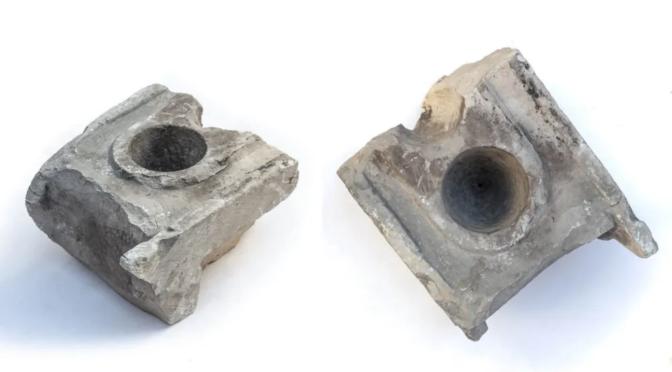
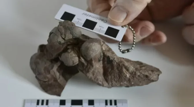
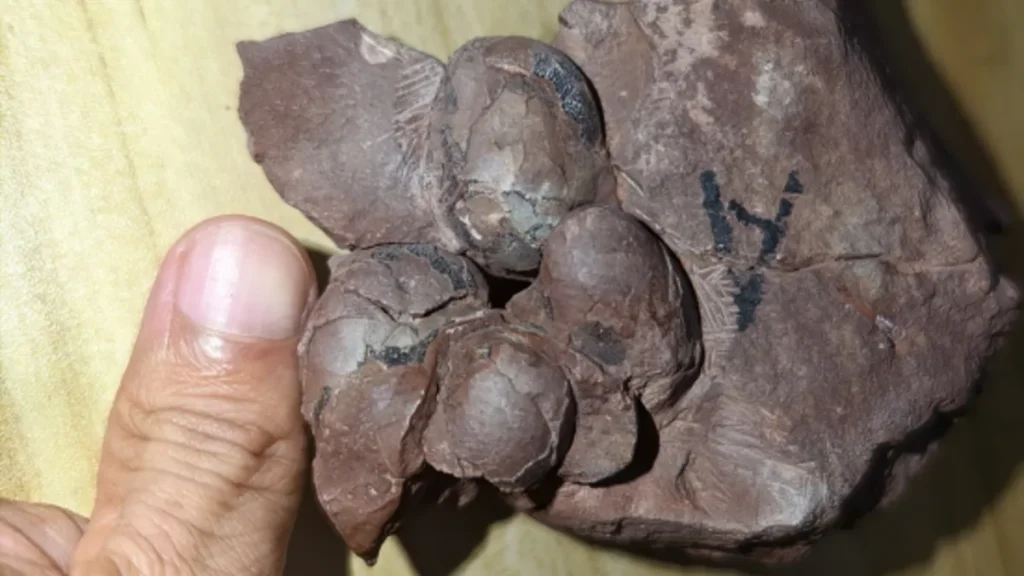
Half a dozen dinosaur eggs, each around the size of a grape, were recently saved from a construction site in China. Researchers say the tiny fossilized shells are exceptionally well preserved.

Six eggs belonging to the newly identified theropod species Minioolithus ganzhouensis were discovered at a construction site near Ganzhou. The smallest was just 1.1 inches wide.

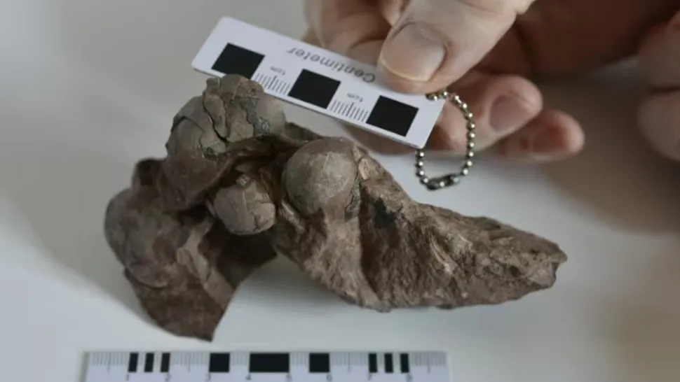
The smallest-ever nonavian dinosaur eggs have been unearthed in China and assigned to a never-before-seen species. The tiny paleontological treasures, each about the size of a grape, were unearthed at a construction site just days from being potentially destroyed by building work.

The six tiny eggs were recovered during a field survey of a construction site near Ganzhou in southeastern China in 2021, Chinese state media reported.

The fossilized shells, known as the “Ganzhou mini eggs,” were irregularly arranged within a lump of rock, making it hard to determine if they were part of a single nest. The rock dates back roughly 80 million years, to the Cretaceous period (145 million to 66 million years ago).

The smallest egg is 1.1 inches (2.9 centimeters) long, smashing the previous record for the smallest nonavian dinosaur egg, which was held by an egg recovered from Japan.

That one was laid by the chicken-size dinosaur Himeoolithus murakamii around 110 million years ago and measured 1.8 inches (4.5 cm), according to Guinness World Records. For comparison, the newly uncovered eggs are around half as long as most chicken eggs.

In a study published Oct. 14 in the journal Historical Biology, researchers revealed that the eggs likely belong to a never-before-seen species of nonavian theropod dinosaur — a group of bipedal, largely predatory dinosaurs such as Tyrannosaurus rex — that they named Minioolithus ganzhouensis. It is currently unclear how large M. ganzhouensis would have grown after hatching.

Researchers say the newly uncovered eggs are surprisingly well preserved despite being 80 million years old.

The tiny eggs are exceptionally well preserved. Detailed analysis of the fossilized shells using scanning electron microscopy revealed that the internal structure of the eggs has remained almost completely intact.

Future studies on these eggs could reveal more about the reproductive biology of Late Cretaceous theropod dinosaurs, study co-author Fenglu Han, a paleontologist at China University of Geosciences in Wuhan, said in a translated statement.

Dinosaur eggs vary widely in shape and size, and their size doesn’t always predict how large the species that laid them could grow. For example, some ornithopods, or duck-billed dinosaurs, laid eggs that were 5.4 inches (13.7 cm) long, while some titanosaurs — the largest creatures ever to walk on land — hatched from eggs that were just 5.9 inches (15 cm) long, despite growing up to four times longer than ornithopods.

The newly discovered eggs are extremely small but not quite as tiny as those laid by some of the last remaining dinosaurs — birds.

The record for the smallest known avian egg belongs to the vervain hummingbird (Mellisuga minima), whose eggs are as small as 0.4 inch (0.1 cm) long and lighter than a paper clip, according to Guinness World Records.

16,000-year-old skeleton, crystals and stone tools discovered in Malaysian caves

16,000-year-old skeleton, crystals and stone tools discovered in Malaysian caves

Archaeologists in Malaysia have uncovered a 16,000-year-old human skeleton in the Gua Kechil cave complex, shedding new light on the region’s prehistoric inhabitants. The remarkable find also includes artifacts providing valuable insights into the lives of some of Southeast Asia’s earliest settlers reports .

This discovery is thought to be one of the oldest human remains ever found in Malaysia and could reveal important details about migration patterns and the region’s ancient culture. It was found along with 15 more recent human remains found across 4 sites in the region.

A Major Prehistoric Discovery

The skeletons have been unearthed during ongoing excavations in the Gua Kechil caves in Pahang, a state in central Malaysia known for its rich archaeological history.

According to Archaeology Magazine, 15 of the remains were buried in a crouched position, a burial practice typical of prehistoric societies, and were accompanied by stone tools and shell artifacts.

One of the remains was found buried straight, and is dated to the Neolithic period approximately 6,000 years ago.

Dating has revealed the earliest skeleton discovered in the Nenggeri Valley caves dates from between 14,000 and 16,000 years ago.

Artifacts Paint a Picture of Prehistoric Life

Alongside the skeletal remains, archaeologists found a range of artifacts including stone tools and shell ornaments that may have been used for both practical and ceremonial purposes.

The discovery of these items could suggest a sophisticated level of craftsmanship and cultural expression among the prehistoric inhabitants of the region. These tools were likely used for hunting and gathering, as well as preparing food and processing materials like hides or plants.

“This is not just a burial site, but also evidence of a thriving prehistoric community,” explained Dr. Omar. “The artifacts we’ve found tell a story of daily life, survival, and even early forms of social or religious customs.”

All but one of the 16 burials discovered in the Nenggiri Valley caves date to the pre-Neolithic period in the region, more than 10,000 years ago.

Insights Into Ancient Migration Patterns

The Gua Kechil find is expected to contribute to a better understanding of ancient human migration patterns across Southeast Asia. During the Pleistocene epoch, Southeast Asia was a key region for human migration due to the land bridges that connected it to other parts of Asia.

This particular discovery may help researchers fill in gaps in the timeline of early human settlement in the region, particularly how ancient populations moved, adapted, and thrived in diverse environments.

Dr. Omar explained to  that the skeletal remains could also shed light on the biological characteristics of these ancient humans. DNA analysis of the bones could reveal information about genetic diversity in early Southeast Asian populations, offering clues to their origins and interactions with other groups.

The discovery may provide “an important piece of the puzzle regarding how early humans populated this region and how they adapted to changing environments over millennia.”

A Site of Great Archaeological Importance

The Gua Kechil caves have long been of interest to archaeologists, as the region has yielded several important prehistoric finds over the years. The recent discovery adds to the site’s significance, marking it as a location where ancient human activity can be traced back thousands of years.

“This cave system is proving to be a treasure trove of prehistoric information,” said Dr. Omar to Fox News. “Each new discovery brings us closer to understanding the rich history of human life in this part of the world.”

As excavations continue, researchers hope to uncover more about the daily lives, beliefs, and survival strategies of the ancient people who inhabited the caves. Future studies, including more detailed analysis of the skeletal remains and artifacts, may reveal even more about the ancient cultures that once flourished in this now remote region of Malaysia.

Dunhuang Manuscripts: Insights into Ancient China

Dunhuang Manuscripts: Insights into Ancient China

Dunhuang is situated in the northwestern part of Gansu province in the west of China. The ancient town occupied a strategic position at the crossroads of the ancient Southern Silk Route and the main road leading from India to Mongolia via Lhasa, as well as controlling the entrance of the Hexi Corridor which led to the heart of the northern Chinese plains and the ancient capitals of Chang’an (modern day Xi’an) and Loyang.

Dunhuang’s unique position also meant that it was a meeting point of various cultures. This is very evident in the Dunhuang manuscripts.

Historical Significance of Dunhuang and the Silk Route

The Dunhuang Manuscripts are a cache of around 20,000 important scrolls found in the Mogao Caves of Dunhuang. The Dunhuang manuscripts date to between the 5th and 11th centuries AD and were sealed up in a chamber in a cave, hidden for about 900 years.

The re-discovery of these precious documents, however, was made completely by accident. Although Dunhuang used to be an important city on the Silk Route during the Middle Ages, it was a backwater by the early 20th century.

As a result of this decline, the numerous Buddhist shrines in the Mogao Caves were in a state of disrepair. This prompted an itinerant Taoist monk by the name of Wang Yuanlu to appoint himself as the caretaker of the caves, and to make an attempt at restoring the derelict shrines.

Digitization of a Dunhuang manuscript

The Accidental Discovery by Wang Yuanlu

The story goes that one day, Wang Yuanlu noticed his cigarette smoke wafting toward the back wall of a large cave shrine (Cave 16 as it is known today). He decided to knock the wall down to see what was behind it. To his amazement, he found a mountain of documents piled in a secret chamber.

Although Wang was unable to read the ancient scripts, he knew that they were incredibly valuable. Thus, the monk decided to contact the local officials and offered to send his findings to the provincial capital. As the Chinese authorities were short of cash and preoccupied with the ongoing Boxer Rebellion, a violent anti-foreign and anti-Christian movement which took place in China towards the end of the Qing dynasty, they refused Wang’s offer.

News of the discovery, however, did not stay in Dunhuang, but soon spread along the caravan routes of Xinjiang. The Hungarian-born explorer and Indologist, Aurel Stein, who was on his second archaeological expedition to Central Asia, was one of the first to hear of it.   

Monk Wang Yuanlu discovered the hidden Library Cave.

After a delicate process of negotiation, Stein managed to convince Wang to sell him about ten thousand scrolls for 130 pounds by claiming that he was following in the footsteps of Xuanzang, a Buddhist monk who made a journey from China to India during the 7th century AD in search of sacred Buddhist texts. Stein’s purchase of these manuscripts sparked a scramble by other European powers to get their hands on the ancient texts, and 10 years later, about 20% of the original material remained when the Chinese authorities transferred the remaining documents to Beijing.

Image of Cave 16 taken by Aurel Stein in 1907, with a small high doorway leading to Cave 17, the Library Cave, seen on the right. The table, bench, and piles of manuscripts near the doorway is Stein’s doctored addition made by overlaying a different photo negative.
Mogao Caves in Dunhuang, China.

Although the Dunhuang Manuscripts contain mostly Buddhist texts, there were other forms of sacred texts as well. These include Taoist, Nestorian Christian, and Manichaean texts. In addition, there were also secular texts that dealt with various areas of knowledge, such as mathematics, history, astronomy, and literature. One of the significant aspects of the Dunhuang Manuscripts can be seen in the large amount of folk literature in it.

Paul Pelliot examining manuscripts in the Library Cave, 1908.

As this form of literature is about the lives of ordinary people, it provides a unique perspective on their experiences, the way they associated with the wider society and the government, as well as their relationships with family and friends.

These insights have led to the revision of some commonly held views about farmers and the governance of agricultural communities. Such developments are promising, as scholars are able to gain a better view of Chinese society during that era.

Furthermore, the International Dunhuang Project, which began in 1994, has allowed scholars from around the world to view digital copies of the various documents of the Dunhuang Manuscripts residing in various museums. The website launch in June 2025, marks the 30th anniversary of the International Dunhuang Programme, formerly called the International Dunhuang Project.

The redesigned platform features a new logo, improved search capabilities, IIIF image viewing, and new resources. This two-year effort aims to better serve researchers and the public, leading to new and exciting discoveries in the future.

The 5,000-Year-Old Pyramid City of Caral: The First City in the Americas

The 5,000-Year-Old Pyramid City of Caral: The First City in the Americas


Seventy thousand years ago, people lived all over South America. Six thousand years ago, people began to construct cities around pyramids, in places like Mesopotamia and China.

The first of these structures in the Americas, between the Andes and the Pacific Oceans, was established 5,000 years ago. Known as Caral, it was a large settlement in the Supe Valley, in what is now Peru. The point is that this gave rise to the first city in the Americas, as well as the most extraordinary archaeological site in the entire world.

Ancient cities all had a common feature, namely their access to fresh water. On the wall, across the board, this is what allowed for the irrigation that was required to form modern cities. In typical fashion, the river in the valley of Caral flowed down from the mountains to the sea.

From this, hoes were then used to dig trenches from the river to the fields. However, since the river only flows between December and April, to have water all year round, they had to build a canal that was fed by two different sources.

Remains of the Great Pyramid of Caral.

Along with the river water, the people of Caral made use of mountain spring water, to hydrate themselves and the plants they depended on. As a result of this, there were soon numerous fruits and vegetables, in a vast oasis, along with acres upon acres of cotton. It must have been an ancient wonder of the world.

Now, although they were expert farmers, the old native Peruvians didn’t know how to fire clay. Instead, they carried things in hand-woven reed baskets. The thing that makes them the most unique, though, is the fact that the Caral-Supe civilization was a peaceful society. That is to say, citizens didn’t own weapons, unlike in almost every other civilization, both ancient and modern alike.

Their overall way of life developed out of a far greater need for welfare than that of warfare. So, the culture didn’t include aggression. Although, it is important to note that, the priests of Caral did engage in human sacrifice.

In this way, they started the tradition of burying people alive in monumental architecture, as would be seen millennia later, in cities like Teotihuacan and Cahokia, in North America. Thus, trapped souls began to serve as protectors of pyramids.

Regardless, Caral was under construction at the same time as the pyramids of Giza, in Ancient Egypt. Like all the other great cities of old, the site was simply enormous.

The temple included a 100-foot tall, multiple structures, a fire altar platform. This was also accompanied by five smaller ritual pyramids, around a central plaza, complete with an amphitheater. There was also housing for 3,000 permanent residents.

As part of this, major repairs needed to be done every two or three generations. Even though they used rather sophisticated anti-seismic methods of construction, it was still necessary to shore up monuments every few decades. They also had to deal with deadly mudslides, in the process.

Nonetheless, despite all the hardships they faced, their peaceful society not only survived, it thrived. It was all based on a complex trade network, which went to Ecuador, and even hundreds of miles away, deep in the rain forests. So, the farmers in Caral grew chili peppers and guava, among many other crops.

The most important thing they produced, though, was cotton. Manufacturers used it to make several textiles, like clothing and fishing nets. Farmers wore the former, and traded the latter to fishermen, miles away in coastal towns. In this way, people in the aristocratic city-state subsisted mainly on shellfish and dried fish, although they had a fairly diverse diet, overall.

The people of Caral brilliantly capitalized on what could have been a disaster. 5,000 years ago, climate change altered the local seascape in the Pacific Ocean.

After the temperature changed, tuna and other big fish moved on to cooler waters. Meanwhile, anchovies and sardines moved in. These new marine products were caught with nets rather than hooks and lines, as people had been doing with the larger fish. Simply put, it became easier to catch smaller fish, in far greater numbers.

In this way, the greater number of fish that were being caught, with the use of more and more nets, allowed for a greater and greater surplus, which drove the economy. This made Caral the central trading hub, in the first major marketplace in the Americas.

As the mother civilization of the New World, the Caral-Supe society set the stage for Native American civilizations, far and wide. Without even knowing how to make pottery yet, they were already expert herbalists. They chewed coca leaves with lime, to enhance the cocaine. They also painted each other with an aphrodisiac, made from the achiote plant. Then, they engaged in orgiastic religious festivals.

The natives were flute-playing lovers, not blade-wielding fighters. Everything they did was based on cooperation, not competition. This is how they lived in peace, for a millennium, from 2600 BCE to 1600 BCE. However, all good things seem to come to an end.

Unfortunately for the people of Caral, every few decades, earthquakes would routinely break up the mountains. As a consequence of this, rubble would get swept away by torrential rains. This would then wash into the river, and out into the ocean. So, after a couple of centuries, the silt built up and sealed off the flow of water.

This filled the life-giving bays with sand, which prevailing winds then blew inland. Thus, with each passing year, the dunes grew bigger and more menacing on the horizon. In the end, the once fertile fields were all reclaimed, by the inhospitable desert, once more.

Ancient DNA reveals that the Biblical Philistines originated in Europe.

Ancient DNA reveals that the Biblical Philistines originated in Europe.


A team of scientists from Germany, the United States and Korea has sequenced and analyzed DNA of 10 Bronze and Iron Age individuals from the ancient Mediterranean port city of Ashkelon, identified as ‘Philistine’ during the Iron Age.

The researchers found that a European derived ancestry was introduced in Ashkelon around the time of the Philistines’ estimated arrival, suggesting that their ancestors migrated across the Mediterranean, reaching Ashkelon by the early Iron Age.

This European genetic component was subsequently diluted by the Levantine gene pool over the succeeding centuries, suggesting intensive admixture between locals and migrants.

Left: captive Philistine warriors from a wall relief at Medinet Habu, Egypt, 1185-1152 BC. Right: an artist’s conception of a Philistine warrior.

The Philistines are famous for their appearance in the Hebrew Bible as the enemies of the Israelites. However, ancient texts tell little about the Philistine origins other than a later memory that they came from ‘Caphtor,’ a Bronze Age name for Crete (Amos 9:7).

More than a century ago, egyptologists proposed that a group called the Peleset in texts of the late 12th century BCE were the same as the Biblical Philistines.

The Egyptians claimed that the Peleset traveled from ‘the islands,’ attacking what is today Cyprus and the Turkish and Syrian coasts, finally attempting to invade Egypt. These hieroglyphic inscriptions were the first indication that the search for the origins of the Philistines should be focused in the late 2nd millennium BCE.

“We found substantial changes in ways of life during the 12th century BCE which we connect to the arrival of the Philistines,” said Professor Daniel Master, an archeologist with the Wheaton Archaeology Museum and director of the Harvard Semitic Museum’s Leon Levy Expedition to Ashkelon, and colleagues.

“Many scholars, however, argued that these cultural changes were merely the result of trade or a local imitation of foreign styles and not the result of a substantial movement of people.”

“Our new study represents the culmination of more than 30 years of archaeological work and genetic research, concluding that the advent of the Philistines in the southern Levant involved a movement of people from the west during the Bronze to Iron Age transition.”

Reconstruction of a Philistine house from the 12th century BCE.

The researchers successfully recovered genomic data from the remains of 10 individuals who lived in Ashkelon during the Bronze and Iron Age.

They then compared DNA of the Bronze and Iron Age people of Ashkelon to determine how they were related.

They found that individuals across all time periods derived most of their ancestry from the local Levantine gene pool, but that individuals who lived in early Iron Age Ashkelon had a European derived ancestral component that was not present in their Bronze Age predecessors.

“This genetic distinction is due to European-related gene flow introduced in Ashkelon during either the end of the Bronze Age or the beginning of the Iron Age,” said Dr. Michal Feldman, a researcher at the Max Planck Institute for the Science of Human History.

“This timing is in accord with estimates of the Philistines arrival to the coast of the Levant, based on archaeological and textual records.”

“While our modeling suggests a southern European gene pool as a plausible source, future sampling could identify more precisely the populations introducing the European-related component to Ashkelon.”

In analyzing later Iron Age individuals from Ashkelon, the researchers found that the European related component could no longer be traced.

“Within no more than two centuries, this genetic footprint introduced during the early Iron Age is no longer detectable and seems to be diluted by a local Levantine related gene pool,” said Dr. Choongwon Jeong, also from the Max Planck Institute of the Science of Human History.

“While, according to ancient texts, the people of Ashkelon in the first millennium BCE remained ‘Philistines’ to their neighbors, the distinctiveness of their genetic makeup was no longer clear, perhaps due to intermarriage with Levantine groups around them,” Professor Master said.

“These data begin to fill a temporal gap in the genetic map of the southern Levant.

At the same time, by the zoomed-in comparative analysis of the Ashkelon genetic time transect, we find that the unique cultural features in the early Iron Age are mirrored by a distinct genetic composition of the early Iron Age people,” said Dr. Johannes Krause, also from the Max Planck Institute for the Science of Human History.

2,000-Year-Old Measuring Table Points to Location of Ancient Jerusalem Market

2,000-Year-Old Measuring Table Points to Location of Ancient Jerusalem Market


A rare Second Temple measuring table was recently discovered in the City of David, and it is causing archaeologists to identify an ancient Jerusalem square as the city’s 2,000-year-old central market, according to Israel Antiquities Authority archaeologist Ari Levy.

In conversation with The Times of Israel on Monday, Levy said the stone table would have belonged to the market’s manager, or agoranomos, who was in charge of the weights and measures of commodities traded in the shuk.

The measuring table was found in a broad paved central square still undergoing excavation, alongside dozens of stone measurement weights. The sum of the parts has led the IAA archaeologists to conclude that this area of the Stepped Street, a paved 2,000-year-old pilgrims’ path that connects the Siloam Pool with the Temple Mount, would have served as ancient Jerusalem’s main market.

“The volume standard table we’ve found, as well as the stone weights discovered nearby, support the theory that this was the site of vast trade activity, and perhaps this may indicate the existence of a market,” said Levy in a press release.

Today, the path is five meters (16 feet) under ground. Archaeologists and historians call the road that is being excavated under an East Jerusalem Arab neighborhood the “Stepped Street.” In more popular parlance it is called the “Pilgrims’ Path” or the “Pilgrimage Road.”

In total, the path stretches some 600 meters long and is eight meters wide. Both sides of the street were lined with shops that were likely two stories high, said Levy during a recent visit there.

It was built starting in 20 CE by the Romans and completed under the governance of Pontius Pilate in about 30 CE. A recent study of 100 coins collected under pavement at the site appears to confirm this dating.

But the Romans, in destroying Jerusalem in 70 CE, covered up all their hard work just 40 years later.

For the past decade, Jerusalem archaeologists have been excavating the dirt and debris that cover the near-mint condition Roman paving stones. Along the way, they’ve uncovered untold artifacts, such as this measuring table.

Only two other such measuring tables have been discovered in Israel: One in the 1970s in the Old City of Jerusalem’s Jewish Quarter by Dr. Nahman Avigad, and the second during excavations in Shuafat in northern Jerusalem in 2007 under Dr. Rahel Bar-Natan.

However, contemporary measuring tables are found in city centers throughout the Roman Empire that used the same system of measures for the volume of the liquids — likely olive oil or wine — as the one found in the City of David find, said Levy.

The fact that the measuring table is made of stone has nothing to do with Temple purity, said archaeologist Levy. Asked who this market manager would have been — Roman or Jewish — Levy laughed and said, “Until we find his identification card, we can’t know.”

The role of the market manager or agoranomos (the Greek agora connotes a central public space), well documented in antiquity, arrived in the Land of Israel during the Hellenistic period.

It is mentioned in the Book of Maccabees, according to an Encyclopedia.com entry: “In Jerusalem, the controversy between Onias, the high priest, and Simeon in regard to the office of the agoranomia was one of the causes of the civil war in the early 70s of the second century b.c.e.” Roman Jewish historian Josephus also makes reference to the office — and the Jerusalem square where he would have sat.

In the Talmud it is described that whereas in Jerusalem prior to the fall of the Second Temple in 70 CE, the market manager would have only been in charge of weights and measures, the office in Babylon expanded to assigning the value of the foodstuffs.

The location of the measuring table and the additional finds of weights in the still partially covered square suggest to the archaeologists that the large paved open area, found in the middle of the path leading to the Temple Mount, served as “the focal point of trade and commerce,” according to an IAA press release announcing the find.

Preliminary research into the table is being conducted by archaeologist Prof. Ronny Reich, an expert in ancient Jerusalem who was among the first to find portions of the sewer system which led to the discovery of the Pilgrims’ Path.

Describing the piece of the stone table top, Reich said in the press release, “We see two of the deep cavities remain, each with a drain at its bottom.

The drain at the bottom could be plugged with a finger, filled with a liquid of some type, and once the finger was removed, the liquid could be drained into a container, therefore determining the volume of the container, using the measurement table as a uniform guideline. This way, traders could calibrate their measuring instruments using a uniform standard.”

The dozens of weights discovered in the town square and the surrounding area were made from flat stones of different weights and sizes. Reich said some 90 percent of weights of this type come from excavations of Second Temple period sites in Jerusalem and are a uniquely Jerusalem weight class.

According to Levy, the accompanying stone measure weights are typical to the period in Jerusalem. “The fact that there were city-specific weights at the site indicates the unique features of the economy and trade in Jerusalem during the Second Temple period, possibly due to the influence of the Temple itself,” he said in the press release.

The City of David’s underground Stepped Street is still being excavated, in two shifts a day, from 7 a.m. to 10 p.m., and will not be fully open to the public for several years, said Levy.

1600-Year-Old Roman Shipwreck Found in “Perfect” Condition in Spain

1600-Year-Old Roman Shipwreck Found in “Perfect” Condition in Spain

In 117 AD, at the time of Caesar Trajan’s death, the Roman Empire had reached its territorial peak, stretching across the Mediterranean Sea to North Africa and Western Asia. And the Romans used ships for much of the things that were sold to or bought from their distant colonies.

As a result, shipwrecks in Mediterranean Sea waters from the Roman era are common. Now another Roman cargo shipwreck, known as the Ses Fontanelles, has been found just off one of the busiest beaches in Mallorca, Spain reports The Guardian.

Dated to the 4th century AD, this incredibly well-preserved Roman cargo ship was carrying hundreds of amphorae of wine, olives, oil, and garum (fermented fish sauce). During a stopover at Mallorca, en route from southwest Spain to Italy, the ship anchored in the Bay of Palma when ferocious waves came and swallowed the vessel, burying it under the shallow seabed.

Project Arqueomallornauta and the Roman Cargo Ship

The Roman cargo shipwreck was first spotted in the summer of 2019. The ship was measured to be roughly 12 meters (39 feet) long.

Particularly surprising was the fact that this ancient shipwreck lay 50 meters (164 feet) from a very busy beach, with its contents only 2 meters (6.5 feet) below sea level. This very touristy beach just off the Balearics welcomes millions of visitors every year, but shockingly, none of the shipwreck artefacts were ever touched after the ship sank.

In the Guardian article Jaume Cardell, the head of archaeology at the Consell of Mallorca said, “The aim is to preserve everything there and all the information it contains, and that couldn’t be done in single emergency intervention. That’s where the project Arqueomallornauta comes in: it’s about recovering and preserving both the wreck and its historical cargo.

This isn’t just about Mallorca; in the whole western Mediterranean, there are very few wrecks with such a singular cargo.”

Researchers from the universities of Barcelona, Cadiz, and the Balearic Islands signed a Memorandum of Understanding (MoU) with the Consell of Mallorca for an inter-university 3-year project called Arqueomallornauta, which will be active till 2023.

The thrust of the project is “analyzing maritime traffic in Majorca in Late Antiquity through underwater findings” as per a press release by the University of Cadiz.

Late Antiquity, or the period between 284 and 700 AD, coincides roughly with the resolution of the Roman Empire’s crisis of the 3rd century, its collapse at the hands of the barbaric tribes, and the early Muslim conquests.

The first part of this MoU was put into action between November 2021, and February 2022, with the excavation of the contents of the ship’s cargo.

The finds were described as “…frankly exceptional, since they have made it possible to fully discover the cargo of the ship, which sank in the middle of the 4th century AD, in an excellent state of conservation,” said the research team.

This exceptional Roman cargo ship finds will shed new light on the condition of the Mediterranean in the 4th century and provide insights into the lives of crew members of such ships.

Just consider these artefacts found on the Mallorca Roman cargo shipwreck: a leather shoe, a rope shoe, a cooking pot, an oil lamp, and a carpenter’s drill (the fourth ever found in this entire region).

There were no human remains of the boat’s crew, however, which suggests that they might have made it to the coast or were swept away by the waves.

An Unparalleled State of Preservation

The best part? The sand created a natural barrier against oxygen, allowing for incomparable preservation of the boat’s organic materials. “Things have been so perfectly preserved that we have found bits of textile, a leather shoe and an espadrille.

The most surprising thing about the boat is just how well preserved it is – even the wood of the hull … It’s wood that you can knock – like it’s from yesterday,” said Dr Miguel Ángel Cau, an archaeologist at the University of Barcelona.

“It’s important in terms of naval architecture because there are very few ancient boats that are as well preserved as this one,” added Dr Darío Bernal-Casasola, an archaeologist at the University of Cádiz. “There are no complete Roman boats in Spain.”

He also notes that the amphorae are still so well preserved that the remains of the contents, the structure of the jar, and the inscriptions on them all remain perfectly intact, calling it an “improbable subaquatic archaeological hat-trick.”

Human Lives Illuminated: The Trading Elite and the Crew

Historian Enrique García Riaza from the University of the Balearic Islands made it clear that this wreck is proof of how important the Balearic archipelago was to the Roman Empire, particularly as a staging post between the Italian and Spanish parts of the Mediterranean.

The elites of the Balearic would have had extensive social and economic relationships with the elites of places like Cartagena and Tarragona.

The crew of the ship were likely Roman pagans, evidenced by the pagan symbol of the moon goddess Diana on an oil lamp found on the wreck. However, some of the ship’s amphorae were imprinted with Christian seals. This would mean that the crew itself was pagan but that the ship carried Christian cargo.

Once the hull of Mallorca’s latest Roman cargo ship is recovered, the plan is to put the ship and its cargo on display, for everyone to see. For the same purpose, conservationists and specialists are being invited to prepare a special report.

The archaeologists are particularly grateful because they acknowledge how easily this find fell into their laps, and the state of preservation only suggests that this is a once in a lifetime find.

Reconstructed Jesus’ Tomb Opened for First Time in 500 Years

Reconstructed Jesus’ Tomb Opened for First Time in 500 Years

The tomb’s contents provides ‘visible proof that the spot the pilgrims worship today really is the same tomb the Roman Emperor Constantine found in the 4th century’. The tomb believed to be the place where Jesus was laid has been opened for the first time in centuries.

For decades, archaeologists and theologians have debated over whether the Church of the Holy Sepulchre in Jerusalem is the site where Christ was supposedly buried and resurrected after being crucified.

The tomb has been sealed in marble since the 1500s in order to prevent visitors from stealing pieces as relics.

Over the preceding centuries, the famous church had been destroyed and rebuilt so many times that experts were left unsure about whether the tomb had been moved and what it might contain.

The entrance of the Tomb of Jesus at the Church of the Holy Sepulchre

Lifting the tomb’s marble lid for the first time in 500 years, researchers discovered the limestone shelf where Jesus’s body was thought to have been placed, the Mirror reported.

Also discovered, was a second grey marble slab previously unknown to the researchers, engraved with a cross they believe was carved in the 12th century by the Crusaders.

Workers at tomb

Archaeologist Fredrik Hiebert of National Geographic, a partner in the project, said: “The most amazing thing for me was when we removed the first layer of dust and found a second piece of marble.

“This one was grey, not creamy white like the exterior, and right in the middle of it was a beautifully inscribed cross. We had no idea that was there.

“The shrine has been destroyed many times by fire, earthquakes, and invasions over the centuries. We didn’t really know if they had built it in exactly the same place every time.

“But this seems to be visible proof that the spot the pilgrims worship today really is the same tomb the Roman Emperor Constantine found in the 4th century and the Crusaders revered. It’s amazing.

The Church of the Holy Sepulchre in Jerusalems Old City

“When we realised what we had found my knees were shaking a little bit.”

According to Christian scripture, Jesus died on the cross and buried for three days before rising from the dead.

Upon opening the ancient tomb, religious leaders from the Greek and Armenian Orthodox churches and the Franciscan monks, who share responsibility for the church, were the first to enter the tomb.

Construction on the tomb

Mr Hiebert added: They came out with big smiles on their face. Then the monks went in and they were all smiling.

“We were all getting really curious. Then we went in, looked into the tomb, and saw a lot of rubble. So it wasn’t empty, even though there were no artefacts or bones.”

Researchers have been involved in discussions as to whether or not the tomb could be opened for vital repairs since 1959, but the committee has faced difficulty in coming to an agreement.

Mr Hiebert said: “Everything has to be approved by the committee, so even changing a candle takes a long time.

”There is a ladder by the main entrance to the church that hasn’t moved in 240 years and they still haven’t reached a decision. It’s called the immovable ladder.

“So the fact we were finally allowed to carry out this work is a triumph of negotiation.”

The original bedrock of the tomb of Jesus Christ

Using ground penetrating radar and thermographic scanners, conservation experts gathered information on the insides of the tomb before unsealing it.

The data is so extensive it will take months to analyse, but the team hope to create a virtual reconstruction for public viewing.

The Ancient Mystery of the Dolmens of the North Caucasus

The Ancient Mystery of the Dolmens of the North Caucasus


Scattered around in some previously inaccessible parts of Russia are some mysterious stone structures built by an ancient megalithic civilization that have endured centuries of both veneration and plunder.

If you ever travel to the North-West Caucasus, you might encounter some strange stone structures that look like miniature houses with round holes in their front walls.

These are the dolmens, ancient megalithic monuments that date back to the early Bronze Age, from the middle of the 4th millennium BC to the end of the 2nd millennium BC.

The dolmens are scattered across the region, from Abkhazia to the Taman Peninsula in an area of approximately 12,000 square kilometers (around 4650 square miles), and are known by the locals as “ispun”, meaning the “houses of dwarves”.

Around 3,000 such megalithic monuments are known in the North Caucasus, with more discoveries regularly happening. The area has the largest concentration of dolmens on Earth.

The construction is remarkable, with massive stone plates fit together without the use of mortar or cement, precisely interlocking via specially crafted grooves. Some joints are so tight that a knife blade cannot pass through.

In 2007, an attempt to reconstruct a dolmen using high-precision electric tools with stones from Gelendzhik’s destroyed structures fell short of the precision achieved by Bronze Age builders.

The dolmens usually consist of a chamber with a large roof slab and an access portal formed by projecting blocks from the side walls and the overhanging roof slab. Most dolmens have a square, semi-circular, or oval access porthole in the center of the façade, which is thought to have been used to place offerings or burials inside the chamber.

Some dolmens have raised patterns (petroglyphs) on their face slabs, such as vertical and horizontal zigzags, hanging triangles, concentric circles, and some depicting pairs of breasts.

These symbols may have had religious or cultural meanings for the builders, but their exact interpretation is still unknown. The dolmens were mainly constructed from fluidogenic rock masses, such as sandstone or limestone, which were hand-carried from nearby quarries to the construction sites.

The purpose and function of the dolmens are still debated by scholars. Some of the dolmens are aligned with astronomical phenomena, such as solstices or equinoxes, indicating that they may have had an astrological or calendrical function.

Some of them are clustered in groups or rows, suggesting that they may have marked territorial boundaries or sacred landscapes. Some of them contain human remains or offerings, indicating that they may have been used for funerary or ceremonial purposes.

The proponents of the theory that the sites were used for tribal worship or ritual ceremonies point out that some dolmens are located in remote areas or on hilltops, away from settlements or cemeteries, and that some dolmens have no traces of burials at all. They also suggest that the petroglyphs may have represented deities or ancestors that were revered by the Dolmen builders.

The identity and origin of the Dolmen builders are also unclear. Some propose that they were associated with the Klin-Yar community in the North Caucasus, or the Koban culture from the Great Caucasus Range.

Others suggest that they were a separate group of people with their own unique culture and traditions. The dolmens may have been built by different tribes or clans over a long period, reflecting their social and political organization.

The dolmens are an enigmatic and fascinating part mysterious prehistoric civilization that left behind these impressive stone monuments. They are also threatened by natural erosion and vandalism, of the Caucasus heritage, revealing glimpses of looting, and urban development.

Many dolmens have been damaged or destroyed over time, and some have been moved or reconstructed for tourism purposes. Efforts are being made to preserve and protect these ancient structures, which are part of the cultural and historical legacy of the region.

Roadside dig Reveals 10,000 Year Old House In Israel

Roadside dig Reveals 10,000 Year Old House In Israel


Archeologists say that while digging at a construction site in Israel, they have uncovered some stunning finds, including stone axes, a “cultic” temple, and traces of a house 10,000 years old.

This image shows the 10,000-year-old house, the oldest dwelling to be unearthed to date in the Judean Shephelah.

The discoveries provide a “broad picture” of human development over thousands of years, from the time when people first started settling in homes to the early days of urban planning, officials with the Israel Antiquities Authority (IAA) said.

In preparation for the widening of an Israeli road, the excavation took place at Eshtaol, about 15 miles (25 kilometers) west of Jerusalem.

The site’s oldest discovery was an 8th millennium B.C. building during the Neolithic period.

“This is the first time that such an ancient structure has been discovered in the Judean Shephelah,” archaeologists with the IAA said, referring to the plains west of Jerusalem.

The building seems to have undergone a number of renovations and represents a time when humans were first starting to live in permanent settlements rather than constantly migrating in search of food, the researchers said.

Near this house, the team found a cluster of abandoned flint and limestone axes.

“Here we have evidence of man’s transition to permanent dwellings and that in fact is the beginning of the domestication of animals and plants; instead of searching out wild sheep, the ancient man started raising them near the house,” the archaeologists said in a statement.

The excavators also say they found the remains of a possible “cultic” temple that’s more than 6,000 years old.

The researchers think this structure, built in the second half of the 5th millennium B.C., was used for ritual purposes because it contains a heavy, 4-foot-tall (1.3 meters) standing stone that is smoothed on all six of its sides and was erected facing east.

Archaeologists think this standing stone, which is worked on all of its sides, is evidence of cultic activity in the Chalcolithic period.

“The large excavation affords us a broad picture of the progression and development of the society in the settlement throughout the ages,” said Amir Golani, one of the excavation directors for the IAA.

Golani added that there is evidence of rural society in Eshtaol making the transition to an urban society in the early Bronze Age, 5,000 years ago.

“We can see distinctly a settlement that gradually became planned, which included alleys and buildings that were extremely impressive from the standpoint of their size and the manner of their construction,” Golani explained in a statement.

“We can clearly trace the urban planning and see the guiding hand of the settlement’s leadership that chose to regulate the construction in the crowded regions in the center of the settlement and allowed less planning along its periphery.

The buildings and artifacts were discovered ahead of the widening of Highway 38, which runs north-south through the city of Beit Shemesh.

Throughout Israel, construction projects often lead to new archaeological discoveries. For example, during recent expansions of Highway 1, the main road connecting Jerusalem and Tel Aviv, excavators discovered 9,500-year-old animal figurines, a carving of a phallus from the Stone Age and a ritual building from the First Temple era.