Archaeologists Discovery 1.8 Million-Year-Old Human Tooth in Georgia
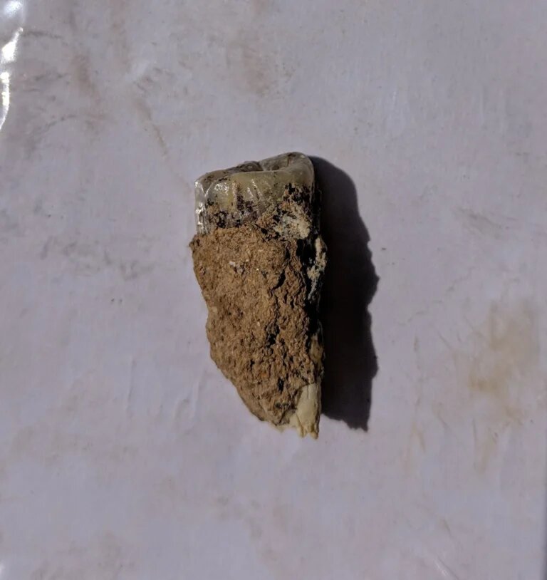
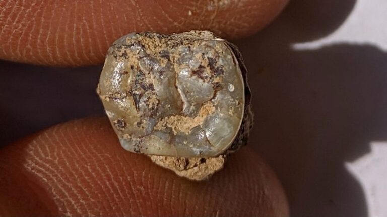
Archaeologists in Georgia have found a 1.8 million-year-old tooth belonging to an early human species.
Scientists say the find labels the region as home to one of the earliest prehistoric archaic human settlements in Europe.
Scientists discovered the tooth near the village of Orozmani, about 100 kilometers southwest of Georgia’s capital, Tbilisi.
The latest discovery provides further evidence that the mountainous South Caucasus region was likely one of the first places early humans settled after migrating from Africa, experts said.
The Molar Found in Georgia is believed to be up to 1.8 Million-Year-Old
Orozmani is located near the city of Dmanisi, where human skulls aged 1.8 million years were found in the late 1990s and early 2000s.
Dmanisi’s findings were the world’s oldest such discovery outside of Africa, and one that changed scientists’ understanding of early human evolution and migration patterns.
Giorgi Bidzinashvili, the scientific leader of the dig team, said he considers the tooth belonged to a “cousin” of Zezva and Mzia, the names given to two near-complete 1.8-million-year-old fossilized skulls found at Dmanisi.
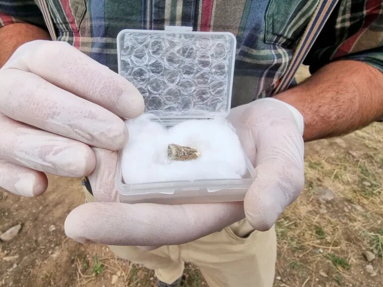
“The implications, not just for this site, but for Georgia and the story of humans leaving Africa 1.8 million years ago are enormous,” said British archaeology student Jack Peart, who first found the tooth at Orozmani.
“It solidifies Georgia as a really important place for paleoanthropology and the human story in general,” he told Reuters.
The oldest Homo fossils anywhere in the world date back to around 2.8 million years ago, when a partial jaw was discovered in Ethiopia, reports DW.
Scientists believe that early humans, a species called Homo erectus, probably began migrating out of Africa about 2 million years ago.
Ancient tools dating back around 2.1 million years have been discovered in modern-day China, but sites in Georgia hold the oldest remains of early humans found outside of Africa.
Anatomically modern humans, Homo sapiens, are thought to have appeared around 300,000 years ago, although estimates vary, in Africa.
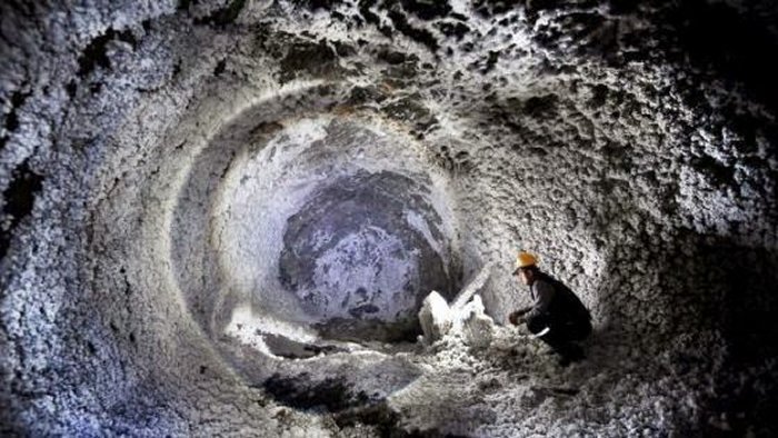
Underground Labyrinth With Secret Passages, Tunnels In Dobrogea Plateau, Romania
In many cases, the world below us is just as fascinating as the ground we walk on. Across Europe, there is a hidden, often millennia-old subterranean realm of tunnels stretching from the north in Scotland leading down to the Mediterranean.
It is an underground world of never-ending tunnels, massive caves, and labyrinths dug by unknown ancient men. There are also underground labyrinths that have not been fully explored yet.
One of them is located about 52 kilometers from Constanța, historically known as Tomis, the oldest continuously inhabited city in Romania.
Limanu Cave’s secret, and still unexplored passages and roads. The network gallery actually resembles a city street map, like the street network of an ancient city developed chaotically, thus the impression of an underground city.
A Vast Underground City Where You Can Get Lost
This vast labyrinth of 12 hectares lies beneath the plateau of Limanu. Researchers started to investigate the place in 1916 and discovered traces left by humans, carved walls and ceilings, and ancient ceramic fragments.
Drawings and inscriptions in Roman and Cyrillic alphabets on the walls prove the cave was inhabited between the 1st century BC and the 10th century AD.
The labyrinth is vast, with a total length of passages of approximately 3.5 km. Dacians used it to hide from the Roman proconsul Marcus Licinius Crassus (c. 115 B.C. —53 BC), who played a vital role in transforming the Roman Republic into the Roman Empire. The cave’s early inhabitants used a marking system to avoid getting lost.
The network of galleries resembles a city street map like the street network of an ancient city developed chaotically, thus the impression of an underground city.
Approximately 4,000 meters in length, Limanu Cave is the longest in Dobrogea. It has a chaotic branching of galleries, like the street network of an ancient city.
Some researchers believe that at least some of the galleries were entirely dug by human beings, as there are tooling marks on the walls. Certainly, Limanu Cave represented an important human refuge, even since Dacian times.
Remarkable Galleries
Some of the galleries have rectangular, very regular sections, and it seems humans carved them as signs of chiseling are visible. In order to avoid the collapse of ceilings, supporting walls and pillars were built in limestone slabs.
The drawings of galloping horses are of particular interest, while their riders have faces displayed from the front. Their silhouette and presentation strikingly resemble those of Dacian riders depicted on pottery discovered in many settlements in the area inhabited by Thraco-Dacians.
The earliest drawings are very likely from the prosperous time of the Geto-Dacian culture, the time when the cave was furnished as well. Other pictures show Christian religious symbols, letters, or words in the Cyrillic alphabet. This artwork belongs to the Roman-Byzantine period and the subsequent times.
Surveys have revealed archaeological material proving that local Dacians inhabited the cave even in that era. Existing evidence allows us to assume that a local Geto-Dacian authority ordered the maze of Limanu as a defense measure against the Roman danger.”
According to Ph.D. Adina Boroneant, “Vasile Pârvan” Institute of Archaeology, Romanian Academy, the Limanu Cave was a shelter for the local population until later, 10th-11th centuries AD.
The account of Dio Cassius shows that the cave was a place of refuge, purposefully chosen and renovated, not some adventitious cavern,” Ph.D. Boroneant writes in his ‘Labirintul subterrane de la Limanu’ (The Underground Labyrinth of Limanu).
Tales Of Mysterious Sounds Coming From Underground Realms
Local stories mention strange and frightening wails like a prolonged high-pitched cry of grief, pain, or anger coming from the depths of the earth.
A scientific explanation for these strange sounds provided by speleologists is that the eerie wails are produced by the wind that sweeps through many underground galleries at Limanu. This noise affects the human psyche.
The cavern has a unique characteristic: although it is located on a complex of lakes and close to the Black Sea, it is so impenetrable that not even water can pass through.
The cave is also known as Caracicula (the old name of the Limanu settlement), Bats’, or Icons’ – due to some images carved in stone that once guarded the entrance.
Limanu Cave is one of the three habitats in Romania for horseshoe bats – Rhinolophus Mehelyi. The species decreased from over 5,000 specimens to about 300 individuals.
However, ecologists warned about the vulnerability of the cave, which is a magnet for treasure hunters. Through their actions, they tend to destroy the fauna.
Being located near the border with Bulgaria, Limanu cave had the reputation of a tunnel carrying fugitives across the border, particularly during the communist time.
There are many reasons to suspect the Dobrogea caves are hiding mysteries still waiting to be discovered.
Archaeologists Discover the 2,000-year-old ‘Sphinx Room’ Hidden in Emperor Nero’s Golden Palace
Archaeologists have discovered a hidden vault in the ruins of Roman Emperor Nero’s sprawling palace, hidden under the hills near Rome’s ancient Colosseum.
According to a statement (translated from Italian) from the Colosseum archaeological park, which includes the palace’s ruins, the chamber has sat hidden for nearly 2,000 years, likely dating to between A.D. 65 and A.D. 68.
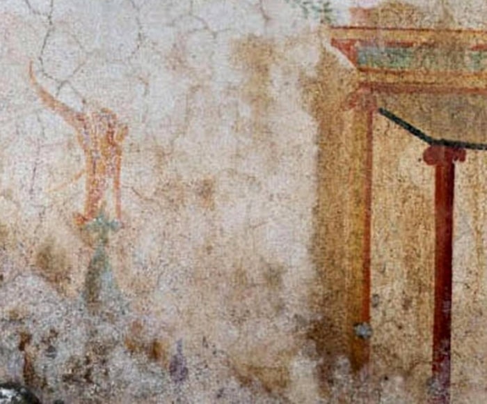
The chamber nicknamed the Sphinx Room, is richly adorned with murals of real and mythical creatures including — you guessed it — a sphinx.
One of the walls of the newly discovered room is painted with a little sphinx.
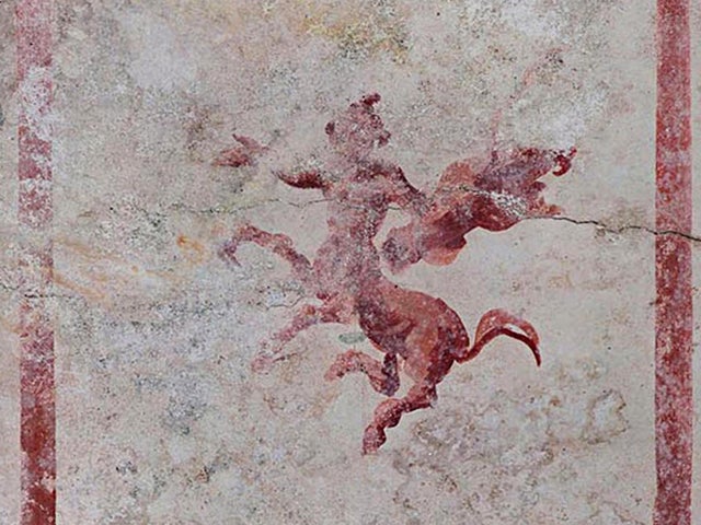
Painted in rich red, green and yellow pigments that have survived the last two millennia incredibly well, the vaulted room is also decorated with images of a centaur, the goat-rumped god Pan, myriad plant and water ornaments, and a scene of a sword-wielding man being attacked by a panther.
According to the statement, the Sphinx Room was discovered accidentally, while researchers were setting up to restore a nearby chamber.
The room’s curved ceilings are 15 feet (4.5 meters) high, and much of the room is still filled in with dirt.
Nero began constructing his massive palace — known as the Domus Aurea, or “golden house” — in A.D. 64 after a devastating, six-day-long fire reduced two-thirds of Rome to ashes.
That researchers are still uncovering new rooms in the Domus Aurea after hundreds of years of excavation (the ruins were first rediscovered in the 15th century) is no surprise.
In its prime, the palace sprawled over four of Rome’s famous seven hills and is believed to have included at least 300 rooms.
One of the centaur’s frescoes in the newly-discovered chamber
Thanks, in part, to his narcissistic construction project, Nero’s reputation suffered in the eyes of history, and he is remembered today as a power-mad despot.
Following Nero’s suicide in A.D. 68, much of his palace was looted, filled with earth, and built over.
One of the palace’s central features, a large manmade lake, was eventually covered up by the Flavian Amphitheater — better known as the Roman Colosseum — in A.D. 70.
Thanks to the lake’s infrastructure, the bottom of the Colosseum was occasionally flooded to wage mock naval battles, bringing glory to the mad emperor’s successors.
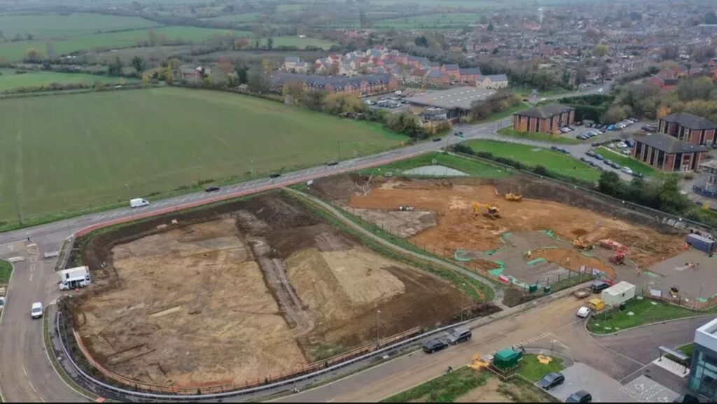
Stunning Roman Villa Unearthed Under New Aldi Supermarket Site
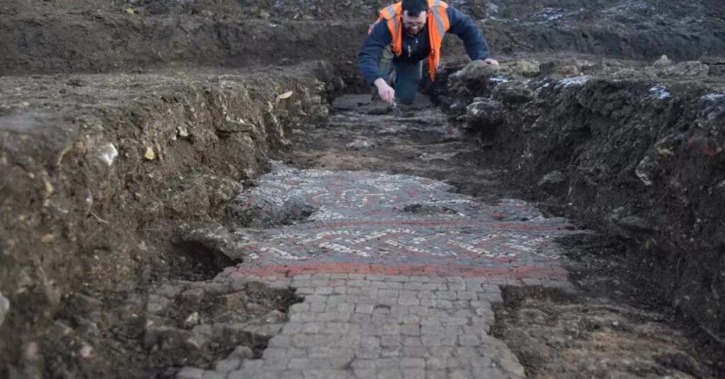
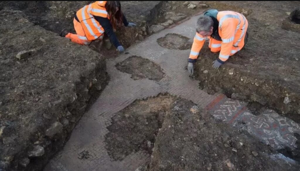
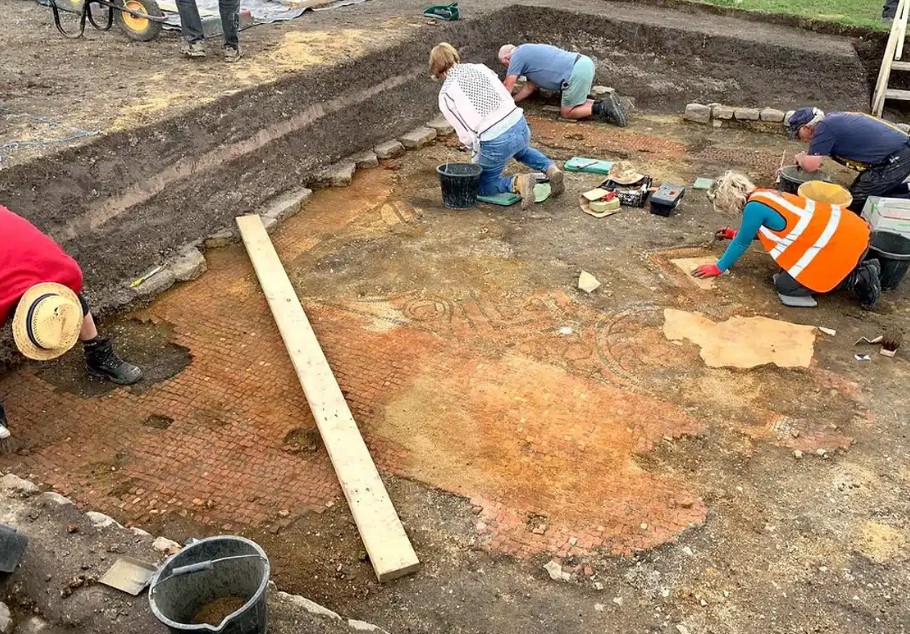
Oxford archaeologists have unearthed what they believe to be a Roman villa which features a stunning mosaic under a site earmarked for a new Aldi supermarket.
A bathhouse, which featured beautiful red, white and blue tiles, was discovered on Warrington Road, Buckinghamshire.
The Olney site is currently being prepared for the construction of a brand-new Aldi supermarket.
The “intricate” mosaic was found at the site of a new Aldi supermarket in the town near Milton Keynes
Archaeologists said the mosaic featured ‘vibrant colours and intricate decorative patterns’ made up of red, white and blue tiles’.
Oxford Archaeology carried out the work for develop Angle Property and was commissioned due to the site’s proximity to another existing Roman site, according to the BBC.
The group deem the mosaic ‘archaeological remains of high significance’.
The roman villa with a “vibrant” mosaic was deemed of “high significance”
It is believed much of the ancient remains extend under Warrington Road, the digl team said.
The archaeologists said that following talks with Historic England and Milton Keynes Council, the mosaic has been preserved in situ.
Materials have been placed over the brickwork to protect the relics and allow construction to continue without causing damage.
Senior project manager at Oxford Archaeology, John Boothroyd, told the BBC: ‘Due to the site location we anticipated some notable Roman remains, but the discovery of this fantastic mosaic far exceeded those expectations.
The site was excavated due to its proximity to an existing Roman settlement monument
‘To be able to preserve remains of this quality and importance is a brilliant outcome, and one that could only have been achieved with the support of Angle Property.’ There are currently 992 ALDI locations in the UK.
New paintings believed to be from the prehistoric era have come to light during the ongoing studies on Mount Latmos (Beşparmak), home to significant rock paintings from ancient times.
Located in the western province of Aydın, the Latmos region is one of the places that attracts attention with its natural beauties, as it is also on the route of local and foreign tourists who want to explore nature and history.
While studies have been carried out to preserve the region and reveal its historical importance, the rock paintings of Latmos shed light on prehistoric times.
The number of the first known prehistoric rock paintings in Western Anatolia, discovered by German Archaeologist Anneliese Peschlow in 1994, has reached 200, with new paintings found since then.
The main subject of Latmos rock paintings, which have unique features in terms of subject and style, is related to the relationship between men and women, family, spring festivals and wedding ceremonies. In many paintings, decorations and figures resembling weaving patterns are also seen.
The newly discovered painting, which is believed to date back to prehistoric times, was found on a rock and in its cavities during the research conducted by the Ecosystem Conservation and Nature Lovers Association (EKODOSD).
Stating that they applied to the Aydın Cultural Heritage Preservation Board after the new discovery, EKODOSD President Bahattin Sürücü said, “There are human figures and ornamental motifs in the paintings drawn on a rock surface and its natural cavities.
It is seen that a figure drawn in a natural cavity has a different shape from the previous rock paintings. Peschlow, who has been working on prehistoric rock paintings in the Latmos region for years, has studied the newly found paintings. It was reported that the painting with interesting figures was not in Peschlow’s records.”
He said that further examinations will be made on the rock paintings by the Directorate General for Preservation of Natural Heritage.
After the first rock painting was discovered in Söğütözü in 1994, nearly 200 paintings have been so far found, Sürücü said.
“Considering that there are thousands of rock shelters and caves on a wide area among the rugged, stacked rocks of the Latmos Mountains, it is a fact that it is difficult and takes decades to study and detect them.
It is not easy to find rock paintings in the complex structure of the Latmos Mountains, which is almost an open-air museum with its castles, ancient stone roads, monasteries and defensive structures.”
“The newly found rock painting shows once again that many paintings drawn by prehistoric artists on thousands of rocks in the Latmos region are waiting to be discovered. Latmos Mountains are world heritage and should be protected as a whole,” he added.
Ancient Shipwreck is Discovered 1,200 Years After Sinking in the Holy Land
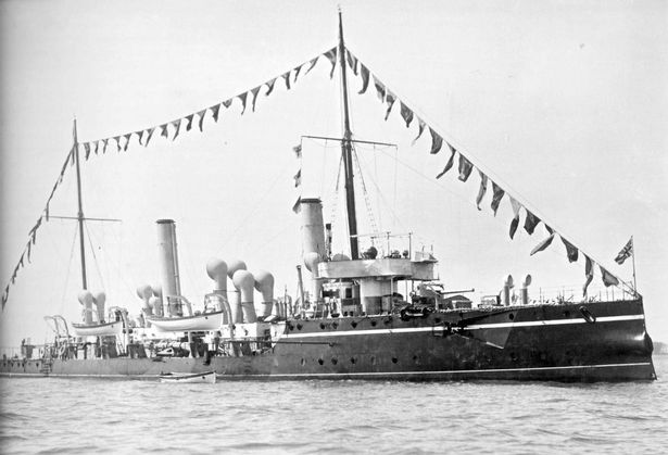
Sunken remains from a Royal Navy warship have been seen for the first time in over a century after divers located the wreck from World War One.
Back in April 1917, HMS Jason struck a German mine off the Scottish island of Coll and as a result, it sank and killed 25 men.
The exact location of the wreck was listed for decades on nautical charts, until 2011 when a seabed survey found no trace of her where she was supposed to be, meaning it was struck from the records.
Now, after five years of research, the remains have been found. Project leader Kevin Heath said: “It’s been known about in diving circles and shipwreck circles in Scotland for a long time.
“It was one of those mysteries – it was out there, people had looked and couldn’t find it, so I thought I’d take it upon myself to have a look.”
He used a side scan sonar to search the seabed when a possible wreck was revealed 600 meters from where Jason was supposed to be lying next to a large rock.
Later on her identity was confirmed on April 12 by a SULA Diving crew, sailing aboard MV Clasina.
Lieutenant Jen Smith of the Royal Navy, who was part of the dive team, said it was an “incredibly moving” discovery. “There was excitement at finding the wreck, but that’s quickly tempered by the fact that it’s a war grave – 25 men died here,” she said.
HMS Jason sunk in 1917 with 25 men killed
“It’s incredibly moving to think that no one has seen the ship since her stern disappeared 105 years ago. “Families knew the fate of the ship, but now they will know where she is and that can bring closure.”
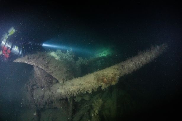
Now the wreck lies at a depth of 93m and has several identifying features, including a pointed stern, a distinctive propeller, two 4.7in guns and crockery.
There is also evidence of the fateful moment that doomed the ship. “It’s been there since World War One so it’s very broken down,” said Mr. Heath.
“But it’s upright, with a slight list to port, the aft gun is there, then all of the machinery is exposed, then there’s the bridge, then there’s a forward gun.
“And just at the forward gun there is a break where the wreckage is missing and that’s where she hit the mine.”
Steps will now be taken to ensure the Jason is protected under law as an official war grave, allowing divers to visit but not touch the wreck.
Lt Smith said: “Documenting the ship, showing people what she’s like today is important to me. Naval war graves are often forgotten, as it’s hard for people to remember what you can’t see.
“Whilst land battlefields and cemeteries such as those in Normandy or the Somme can be visited by anyone, only a few of us can visit a shipwreck.
“So the more we can show and explain what happened to her and her sailors, the better. It’s important to make sure those who served are not forgotten.”
HMS Jason was built as a torpedo gunboat in 1892 but was later converted into a minesweeper by 1909, continuing her duties throughout the First World War.
Sadly she sank in little more than five minutes – enough time for nearly 80 survivors to escape, before being rescued by HMS Circe.
Steve Mortimer, who led the dive group, said: “It was a privilege to help identify the remains of this vessel. “25 families can now take comfort that the location of their relative’s ship is precisely known. We think that’s important.”
Mr. Heath and his fellow historian Wendy Sadler have documented the story of the Jason and its crew at lostinwatersdeep.co.uk
The Largest Hoard of Viking Treasure Ever Found in Britain has Now Been Revealed to the World
The largest hoard of Viking treasure ever found in Britain has now been revealed to the world. In total, there are about 100 intricate pieces, dating to about the 9th and 10th centuries. These rare artifacts were found in Dumfries and Galloway, Scotland, by Derek McLennan, a metal detectorist.
When McLennan, 47, found the hoard in September 2014, he called his wife with the news of the discovery and was so emotional that she thought he had been in a car accident.
He had been painstakingly searching an unidentified area of Church of Scotland land in Dumfries and Galloway for more than a year. McLennan is no stranger to finding treasure. He had been part of a group that discovered more than 300 medieval silver coins shortly before Christmas in 2013.
Derek McLennan, the discoverer of the hoard, holding ingots and arm-rings
Reverend Doctor David Bartholomew, a Church of Scotland minister of a rural Galloway charge, and Mike Smith, the pastor of an Elim Pentecostal Church in Galloway were with McLennan when he made the find.
“We were searching elsewhere when Derek [McLennan] initially thought he’d discovered a Viking gaming piece.” Rev. Dr. Bartholomew recalled that moment. “A short time later, he ran over to us waving a silver arm ring and shouting, ‘Viking!’.”
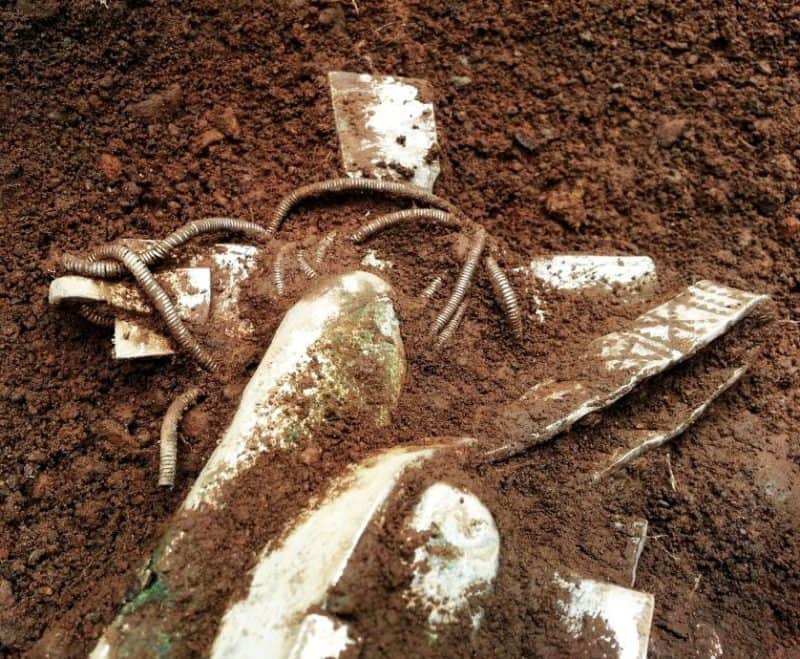
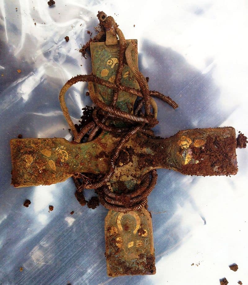
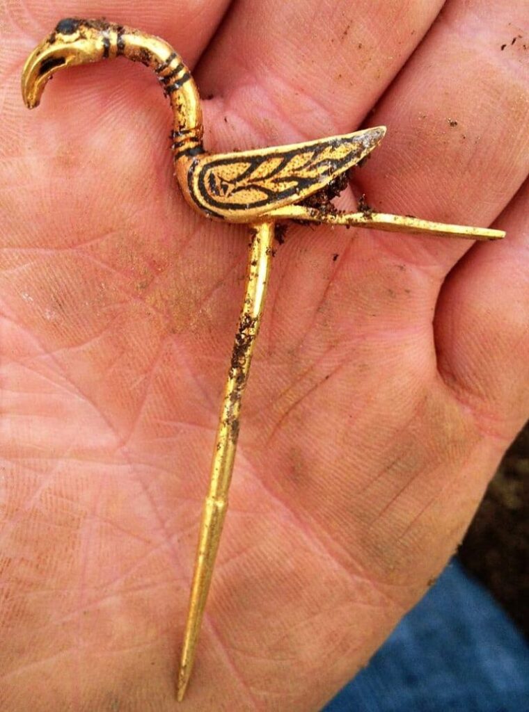
Now, two years after their discovery and 1,000 years after their burial, the artifacts have been revealed. A silver brooch from Ireland, silk from modern-day Turkey, gold and silver ingots, a bird-shaped pin, crystal, and silver arm rings are just a few of the items found. Interestingly, the oval shape of the arm rings suggests that they were actually worn before they were buried.
Top-level of the Dumfriesshire Hoard shows an early medieval cross with other silver and gold objects
Many of these precious pieces were stashed inside a silver Viking pot, dating from the Carolingian dynasty. At the time of its burial, it was likely already 100 years old and a precious heirloom. It is possibly the largest pot from the Carolingian dynasty found so far.
At the time of the discovery, McLennan noted, “We don’t know what exactly is in the pot, but I hope it could reveal who these artifacts belonged to, or at least where they came from.”
The treasure trove was buried two feet deep in the soil and was separated into two levels. Although all the artifacts found are rare and precious, it was the second, lower level that held the particularly fascinating items. It was the second level where the Carolingian dynasty pot was located.
The excavation was undertaken by Andrew Nicholson, the county archaeologist, and Richard Welander, from Historic Environment Scotland.
According to Welander, “Before removing the objects we took the rather unusual measure of having the pot CT-scanned, in order that we could get a rough idea of what was in there and best plan the delicate extraction process.
That exercise offered us a tantalizing glimpse but didn’t prepare me for what was to come. These stunning objects provide us with unparalleled insight into what was going on in the minds of the Vikings in Galloway all those years ago.”
He continued, “They tell us about the sensibilities of the time, reveal displays of regal rivalries and some of the objects even betray an underlying sense of humor, which the Vikings aren’t always renowned for.”
All the discoverers have been left reeling with their find. Rev. Dr. Bartholomew said, “It was tremendously exciting, especially when we noticed the silver cross lying face-downwards.
It was poking out from under the pile of silver ingots and decorated arm rings, with a finely wound silver chain still attached to it. Here, an archaeologist prepares the cross, which was found at the top level of the hoard, for removal. It was a heart-stopping moment when the local archaeologist turned it over to reveal rich decoration on the other side.”
Early medieval cross
Their excitement is well deserved. Scotland’s Culture Secretary Fiona Hyslop said of the hoard, “The Vikings were well known for having raided these shores in the past, but today we can appreciate what they have left behind, with this wonderful addition to Scotland’s cultural heritage.
It’s clear that these artifacts are of great value in themselves, but their greatest value will be in what they can contribute to our understanding of life in early medieval Scotland, and what they tell us about the interaction between the different peoples in these islands at that time.”
An early medieval cross, made of gold, was among the largest artifacts found. Due to its size, it was not located in the Carolingian pot. The cross is engraved with decorations that experts say are highly unusual.
McLennan believes that the engravings may represent the four Gospels of Matthew, Mark, Luke, and John. Richard Welland believes that the carvings “resemble the carvings you can see on the remnants of St Cuthbert’s coffin in Durham Cathedral. For me, the cross opens up the possibility of an intriguing connection with Lindisfarne and Iona.”
Gold bird pin
The Treasure Trove Unit, which is responsible for assessing the value of the find on behalf of the Office of Queen’s and Lord Treasurer’s Remembrancer, is now in possession of the Viking hoard.
The experts of the unit validated the claim that the find has significant international importance. After being fully examined, the hoard will be offered for allocation to Scottish museums. McLennan is eligible for a reward equal to the market value of the find – a cost that will be met by the successful museum.
Concerning money, an agreement between the landowners — the Church of Scotland General Trustees — and the finder, McLennan has been reached. David Robertson, Secretary to the General Trustees, said, “Any money arising from this will first and foremost be used for the good of the local parish.
Archaeologist Discovered Viking Ship Found Under the Ground in Norway
Archaeologists in Norway using ground-penetrating radar have detected one of the largest Viking ship graves ever found. Archaeologists have found the outlines of a Viking ship buried not far from the Norwegian capital of Oslo.
The 65-foot-long ship was covered over more than 1,000 years ago to serve as the final resting place of a prominent Viking king or queen. That makes it one of the largest Viking ship graves ever discovered.
An image generated by ground-penetrating radar reveals the outlines of a Viking ship within a burial mound. Experts say intact Viking ship graves of this size are vanishingly uncommon.
“I think we could talk about a hundred-year find,” says archaeologist Jan Bill, curator of Viking ships at the Museum of Cultural History in Oslo. “It’s quite spectacular from an archaeology perspective.”
The site where the ship grave was discovered is well-known. A burial mound 30 feet tall looms over the site, serving as a local landmark visible from the expressway just north of the Swedish border.
But archaeologists thought any archaeological remains in the nearby fields must have been destroyed by farmers’ plows in the late nineteenth century.
An image generated by ground-penetrating radar reveals the outlines of a Viking ship within a burial mound.
Then, this spring, officials from the surrounding county of Ostfold asked experts from the Norwegian Institute for Cultural Research to survey the fields using a large ground-penetrating radar array.
They were able to scan the soil underneath almost 10 acres of farmland around the mound. Underneath, they found proof of 10 large graves and traces of a ship’s hull, hidden just 20 inches beneath the surface.
Knut Paasche, head of the archaeology department at the Norwegian Institute for Cultural Research and executive of the recent work at the site, estimates the ship was at least 65 feet long.
It appears to be well preserved, with clear outlines of the keel and the first few strakes, or lines of planking, visible in the radar scans. The ship would have been dragged onshore from the nearby Oslo fjord. At some point during the Viking Age, it was the final resting place of someone powerful.
“Ships like this functioned as a coffin,” says Paasche. “There was one king or queen or local chieftain on board.”
The Viking ship was discovered by georadar at Jellestad next to the monumental Jell Mound in Ostfold.
Whoever was buried in the ship was not alone. There are traces of at least 8 other burial mounds in the field, some almost 90 feet across. Three large longhouses-one 150 feet long-are also visible underneath the site’s soil, together with a half dozen smaller structures.
Archaeologists hope future unearthings will help date the mounds and the longhouses, which may have been built at different times. “We can not be sure the houses have the same age as the ship,” Paasche says.
Paasche plans to return to the site next spring to lead more sophisticated scans, including surveying the site with a magnetometer and perhaps digging test trenches to see what condition the ship’s remains are in.
The ship burial forms a part of a larger mound cemetery and settlement site from the Iron Age next to the Jell Mound
If there is wood from the ship’s hull preserved beneath the ground, it could be used to date the find more decisively.
The chances of finding a king’s fortune are slim. Because they were so prominent in the landscape, many Viking Age burials were robbed centuries ago, long before they were leveled by Nineteenth-century farmers.
But “it would be very exciting to see if the burial is still intact,” says Bill. “If it is, it could be holding some very interesting finds.”
‘Rare and significant’ brooch found at site linked to King Arthur
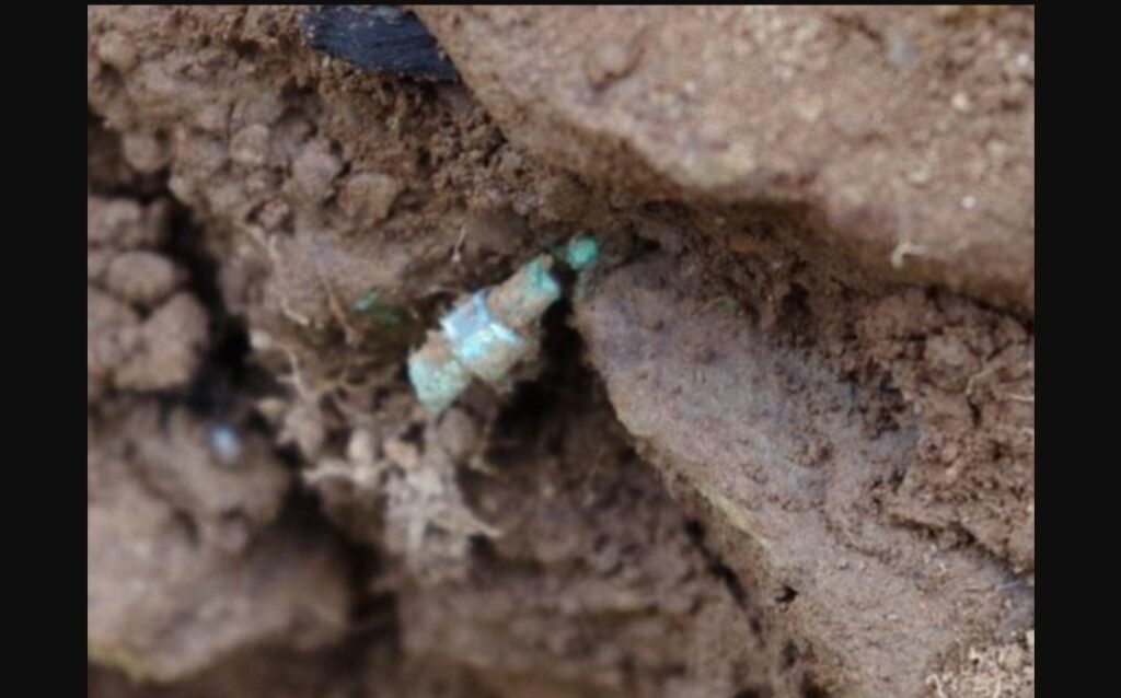
A copper brooch that could be up to 2000-years-old has been discovered close to a site linked to the legendary King Arthur.
The piece of jewellery is thought to date back to the Romano-British period while the country was under Roman rule.
Some reports have even suggested it could have even belonged to King Arthur’s wife Guinevere, but archaeologists say it is unlikely to have belonged to the queen.
A copper brooch has been discovered in Cornwall close to a site linked to the legendary King Arthur.
It is thought the precious brooch was dropped by a wealthy noble woman as she walked through the area.
Archaeologists stumbled across the piece of jewellery that is understood to be the first physical proof that the area was home to the rich and powerful during the time during excavations.
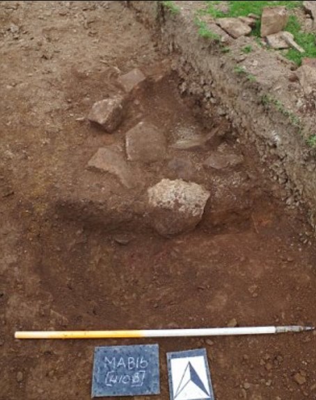
The brooch was found in a field known as Chapelfield, where developers are seeking planning permission to build 14 houses.
According to a public report by Cornwall council, the brooch ‘is a rare and significant find, suggestive of a reasonably “well-healed” Romano-British farmstead settlement.’
The Romano-British period dates from the Roman conquest in AD 43 to when the Romans left in AD 410.
The brooch was discovered in St Mabyn, Cornwall, less than a mile from a hill fort which has previously been suggested might have been the site of King Arthur’s Camelot.
‘Its location within the upper fill of the eastern enclosure ditch suggests that the piece represents accidental loss, perhaps as a result of it having been broken in antiquity’ the report says.
But others do not agree the brooch is rare.
‘It is a penannular brooch dating from the Romano-British period,’ Andrew Young, from the Cornwall Archaeology Unit told MailOnline.
He said the conditions in which it was buried mean it will not have been well-preserved.
‘Such brooches are by no means unusual, although in Cornwall the acid soils mean that survival of metal objects such as this is rather patchy.’
The brooch was photographed while in the soil and sent to the Royal Cornwall Museum to be prepared and conserved.
‘Once it has been cleaned and conserved it will be photographed again,’ Mr Young told MailOnline.
Pit from the south, showing in situ stones. The acid soils mean metal objects often corrode
Some reports had suggested the brooch might have belonged to the legendary King Arthur’s wife Guinevere, but Mr Young does not believe it could.
The facts around the real King Arthur are mired in myth and folklore, but historians believe he ruled Britain from the late 5th and early 6th centuries.
‘I should also point out that it is earlier than the legendary King Arthur by several hundred years,’ Mr Young said.
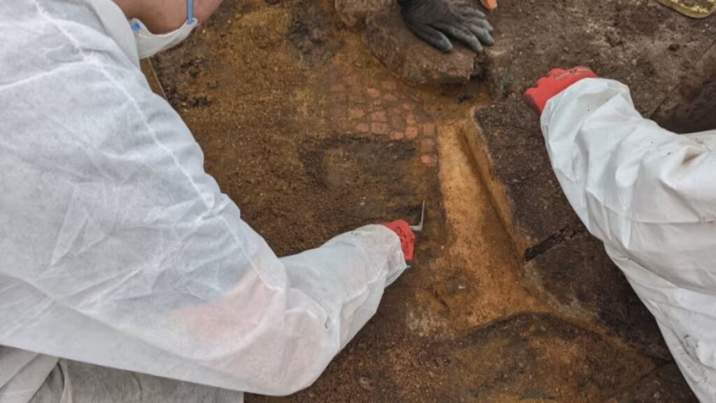
Roman Mosaic Re-Exposed by Archaeologists In Folkestone
The Remains of a Roman mosaic reburied 65-years-ago has been re-exposed by Archaeologists from the canterbury Archaeologists trust
The mosaic is part of the central dining room from a large 2nd century villa complex situated on the cliffs overlooking Folkestone, England.
Beneath the Roman foundations are traces of an earlier Iron Age settlement, occupied by native Britons centuries before the Roman invasion.
Several rooms of a bath-suite have already been lost since they were first excavated due to continuing coastal erosion.
The complex was first excavated by archaeologists in 1924, however, the cost of maintaining the site led to the mosaic being reburied to preserve the monument.
Local accounts at the time reported the mosaic being in a poor state of preservation.
Excavations during the 1920’s found Classis Britannica tiles which suggests that the villa might have a connection to the Roman Navy in Britain, or that the villa was possibly some sort of signalling station.
For reasons that are unclear, the villa seems to have been abandoned sometime in the late third century. It was briefly reoccupied in the 4th century, before it was abandoned and buried under sediments.
Due to the threat of coastal erosion, the mosaic is now under threat of falling into the sea, evidenced by the loss of several rooms of a bath-suite which have already been lost since the 1920’s.
Beginning in 2010, the Canterbury Archaeological Trust has been recording sites under threat as part of a collaboration with local volunteers and university students.
The aim of the study at the Folkestone mosaic is to determine what still survives and how best to preserve the monument.
The team found that the southern part of the mosaic survives, thanks in part to the restoration works conducted in the 1920s to stabilise what remained of the Roman designs.
After documenting the remains, the mosaic will re-buried while discussions on whether it should be lifted and preserved for displaying in a museum are undertaken.