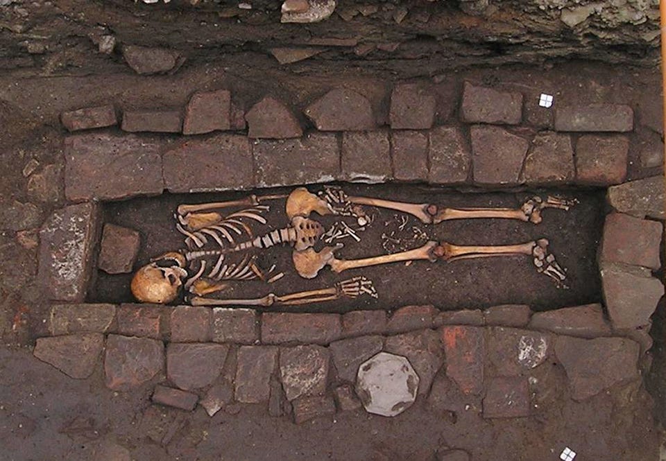
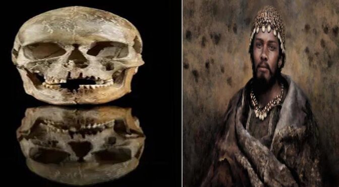
Considering Finland’s highly acidic soil, archaeologists were surprised to find animal fur and feathers buried alongside a child from the Stone Age.
A Stone Age burial in Finland holds the remains of a child, as well as an assortment of grave goods, bird feathers, canine hairs and plant fibers, giving archaeologists insight into burial practices from that time period.
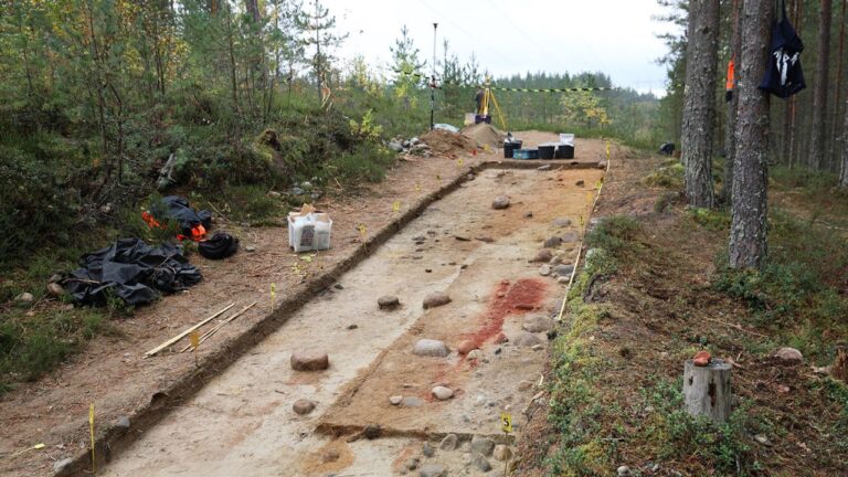
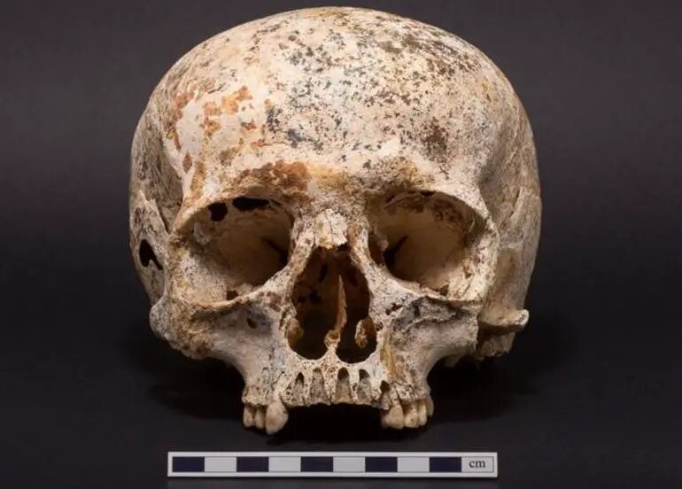
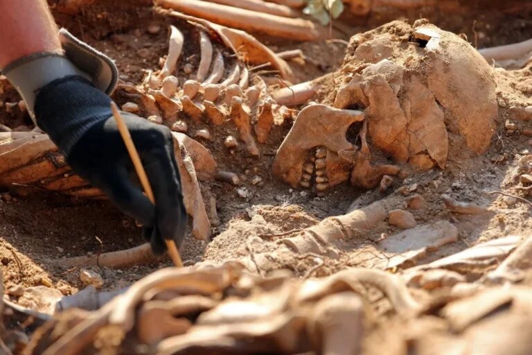
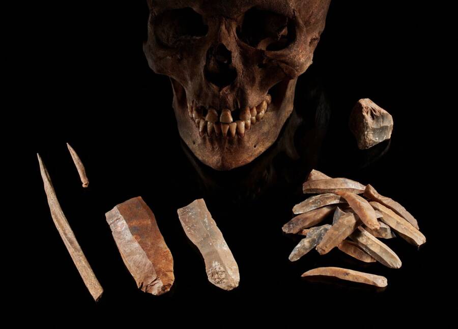
A couple of teeth and arrowheads were found in the grave. First discovered in 1991 in Majoonsuo, an archaeological site near the town of Outokumpu in eastern Finland, the grave contains the teeth of a child, who, based on a dental analysis, died between the ages of 3 and 10.
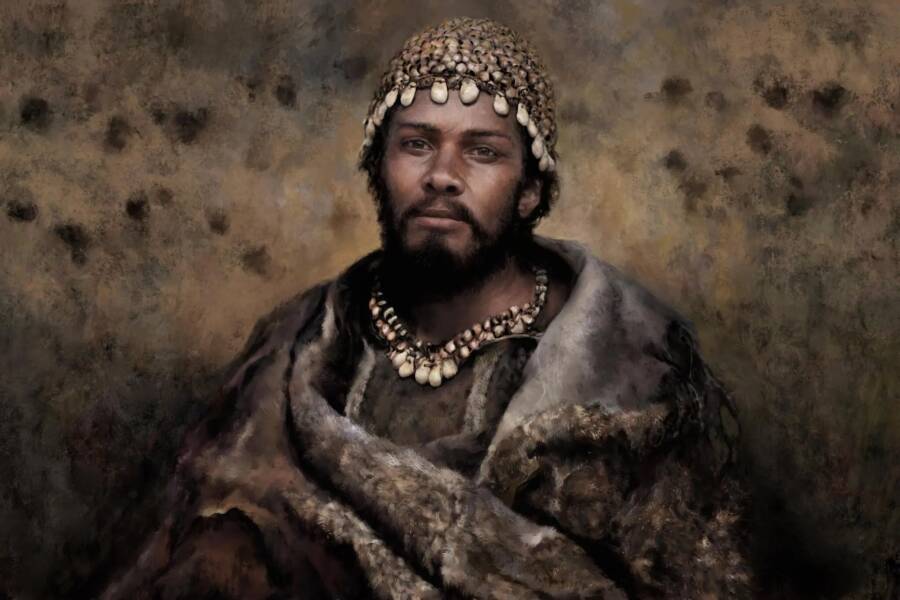
An artist’s impression of what the child may have looked like. Researchers think a dog or wolf was buried alongside the deceased.
Archaeologists from the Finnish Heritage Agency, a cultural and research institution in Helsinki, determined it was a grave site based on red ochre — an iron-rich soil commonly associated with burial sites and rock art — that had stained a gravel roadway. The agency’s excavation team examined the site in 2018 and determined that it was “at risk of destruction,” according to a statement.
Oldest Feather Fragments Found in Finland
Based on the trapezoidal shape of two arrowheads made of quartz, the archaeologists determined that the grave dates to the Mesolithic period, or Middle Stone Age, roughly 8,000 years ago.
After analyzing soil samples, the researchers discovered barbules from the feathers of waterfowl that could have been used to create a bed of down feathers for the child; they also found a single falcon feather fragment. This falcon feather may have been fletching that helped guide an arrow, or perhaps a decoration on a garment, the researchers said.
Wolf Hairs
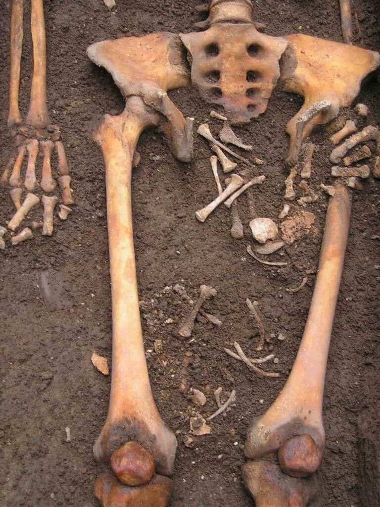
At the base of the burial lay 24 fragments of mammalian hair. While many of the hairs were badly degraded, the researchers determined that three came from a canine, possibly a wolf or a dog that may have been laid at the feet of the child as part of the burial.
It’s also possible that the canid hairs came from clothing, such as footwear crafted from dogskin or wolfskin, worn by the child, the teams noted.
The ochre-red stain on the roadway was what initially tipped off archaeologists about a possible burial site.
“Dogs interred with the deceased have been found in, for example, Skateholm, a famous burial site in southern Sweden dating back some 7,000 years,” Kristiina Mannermaa, a researcher and associate professor in the Department of Cultures at the University of Helsinki, said in the statement.
“The discovery in Majoonsuo is sensational, even though there is nothing but hairs left of the animal or animals — not even teeth. We don’t even know whether it’s a dog or a wolf.”
She added, “The method used demonstrates that traces of fur and feathers can be found even in graves several thousands of years old, including in Finland.”
Bright red ocher marked the spot of the grave, uncovered on a service road in a forest in Eastern Finland.
In addition, archaeologists unearthed plant fibers, possibly from willows or nettles, that might have been used to make clothing or fishing nets. Because the soil in this area of Finland is highly acidic, the archaeologists were surprised at how well some of the organic remains have lasted over the centuries.
The Papuan Tribe Cares For a 250-year-old Mummy To preserve Ancient Rite
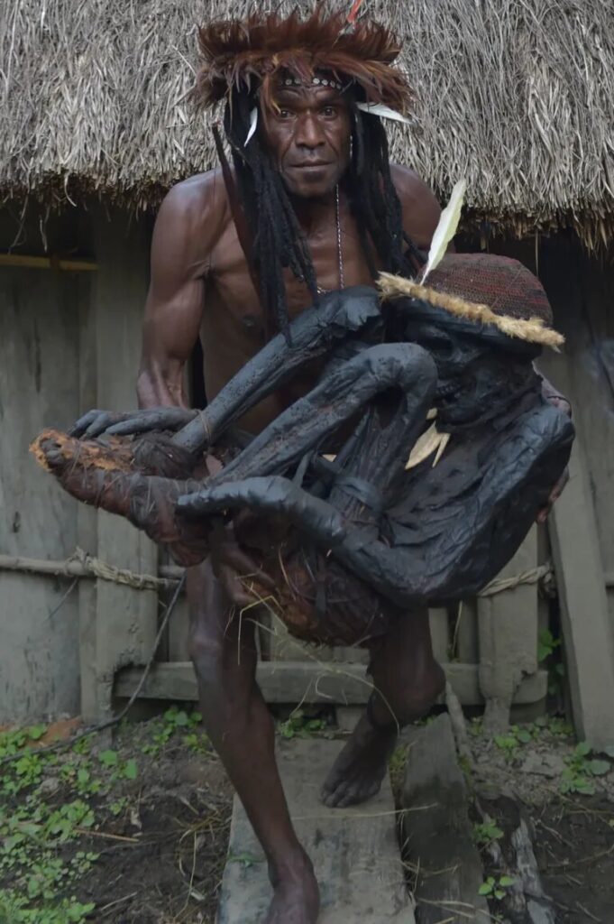
It’s all about paying respect and preserving a tradition. How would you like to spend the night with the mummified remains of a long-dead relative?
What sounds like a scene from some schlocky horror flick is part of real life for a tribal leader in Wogi,a remote village in the Indonesian province of Papua.
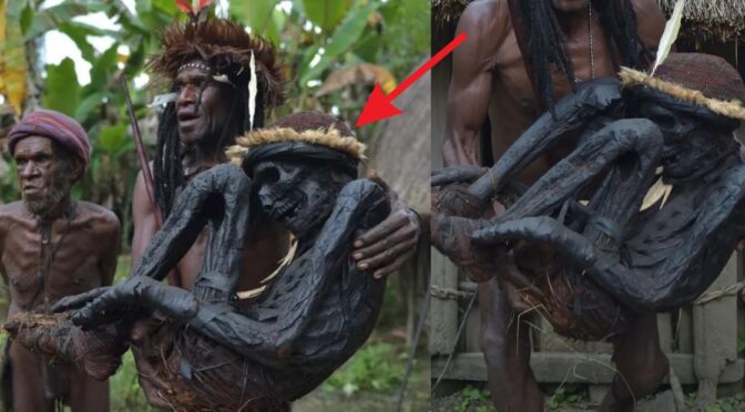
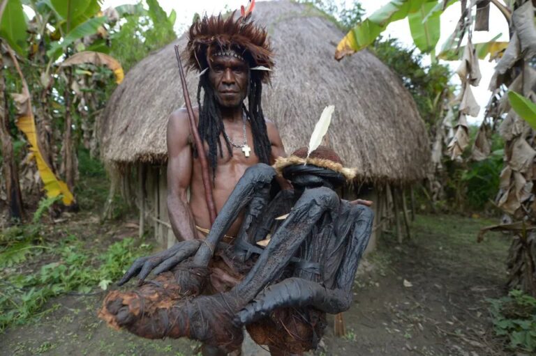
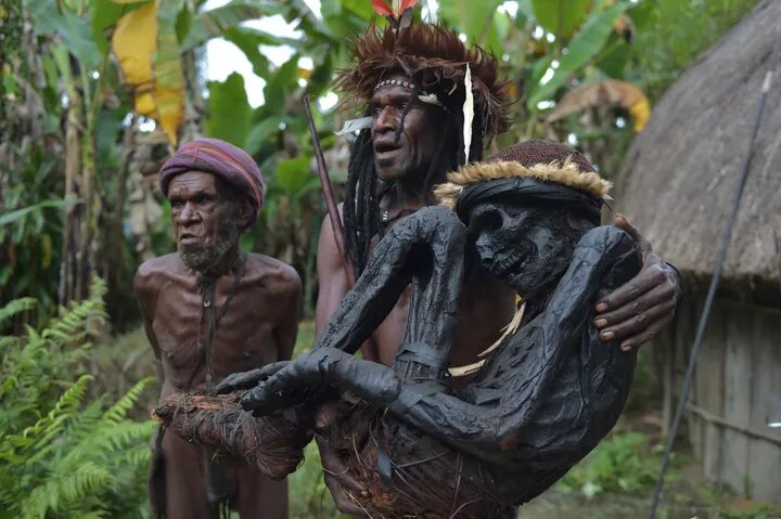
Eli Mabel of the Dani tribe (see more remarkable photos below) spends many nights in the hut where the mummy is kept to make sure nothing happens to it, he told Agence France-Presse.
In protecting the blackened mummy ― said to be the remains of an ancestor of his who ruled some 250 years ago ― Mabel aims to preserve the old Dani tradition of mummification,in which the bodies of venerated tribespeople were preserved with smoke after death.
“We must protect our culture, including the ceremonies for the mummy, the way we treat it, and maintain and fire for it,” Mabel told AFP.
The mummy is decorated with feathers, pig tusks and a traditional gourd covering for the penis. A fire is kept burning in the hut, which is known as a “honai.”
To mummify the bodies, the Dani people dried them under the sun and then stashed them in a cave, Dr. Semiarto Aji Purwanto, a lecturer in anthropology at the University of Indonesia and an expert on Dani culture, told The Huffington Post in an email.
Next, he said, the remains were exposed to hot smoke, drained of liquified fat through piercings and slathered with lard. The entire process took months.
Why go to all that trouble?
“By keeping their bodies, [the Dani] believed to have [the] blessing from the ancestor so they can be more prosperous,” Purwanto said, adding that all of the Dani mummies are curled up “like a fetus when in the womb.”
Mummification was once common among the Dani but died out after Christian missionaries who came to the area 30 to 50 years ago encouraged them to bury rather than mummify their dead, Purwanto said, adding that only six or seven mummies are left. But mummies never die.
This photo, taken on Aug. 7, 2016, shows chief Eli Mabel with the mummified remains of his ancestor Agat Mamete Mabel outside a traditional house in the village of Wogi in Wamena, the long-isolated home of the Dani tribe high in the Papuan central highlands.
The Dani people no longer practice mummification, but tribespeople keeps a number of mummies, some a few hundred years old, as a symbol of respect to their ancestors.
The mummy is curled up like a fetus, like all mummies in the Dani tradition.
Dani man in Wamena on Aug. 8, 2016. The man was participating in the 27th Baliem Valley Festival, featuring highland tribes of Dani, Yali and Lani in their mock battles as a symbol of high spirit and power that have been practiced for generations. The festival was held from Aug. 8 – 10.
Giant Prehistoric Shark Teeth Discovered In The Desert
Several giant teeth from an extinct prehistoric megalodon shark have been found in Chile’s Atacama Desert, and a top expert has said that despite treasure hunters pillaging the area, the South American country still has “one of the largest scientific collections of megalodon teeth in the world.”
The discovery of the giant teeth belonging to the prehistoric shark that is believed to have lived between 23 million and 2 million years ago took place in the Bahia Inglesa Formation, located in the Atacama Desert near the Pacific coast of northern Chile.
The megalodon — whose name means big teeth — was “by far the largest shark of all time, a super predator whose length is estimated to be between 16 and 20 meters (52 and 66 feet) long,” said Pablo Quilodran executive director of the Atacama Paleontology and Natural History Research and Advancement Corp.
“In the Atacama region, there are extraordinary fossil deposits, and in the case of the coast, there are remains of marine vertebrates from about 8 million years ago (the Neogene period).”
Extensive mining operations and looting by treasure hunters had led to possibly hundreds of teeth from megalodons and other prehistoric artifacts being sold on the black market, said Quilodran.
“Although in Chile fossils are protected by law, for many years one of the most spectacular localities, the Bahia Inglesa Formation, was the victim of destruction by deregulated mining operations and from looting by illegal fossil hunters,” he said.
On a more positive note, he said some looted artifacts have been returned to Chile in recent years, allowing it to build the world’s most impressive collection.
“According to informal counts, we know that hundreds of megalodon teeth were found and sold on the international market. Some of them were returned to the Paleontological Museum of the city of Caldera and the Chilean National Museum of Natural History.
The largest Megalodon tooth measures 7.48 Inches and comes from the Ocucaje desert in Peru.
“With this, we undoubtedly have one of the largest scientific collections of megalodon teeth in the world.”
How is it teeth from a marine animal were found in the middle of a desert?
“Because the sea level has changed over millions of years (marine transgression and regression),” the expert said. “This is visible not only in the abundant marine fossils found in sediments today but also in the geomorphology of this part of the desert, where we can see natural esplanades, which are ancient marine terraces that testify to these different sea levels.
“In short, the sea has receded, but the ground has also risen as a result of earthquakes and subduction of plates, phenomena that we Chileans know and experience so well.”
Such finds are nothing new; English naturalist and evolution theorist Charles Darwin reported having found some megalodon teeth during his trip to Chile in 1835, Quilodran said, while recent discoveries had put the total number of different shark species found in the area to 25.
“In the case of sharks, it is not only megalodon; we recently found a new sawshark record for the area, which adds up to more than 25 different species of shark that have been found in the sector.”
A lot of these discoveries were apparently due to sheer luck. “Many of these findings are fortuitous and did not respond to systematic scientific activity,” Quilodran said.
But future discoveries will likely be subject to more rigorous planning, due to the recent creation of the Atacama Paleontology and Natural History Research and Advancement Corp.
The implications of the discoveries of megalodon teeth in the Atacama Desert are huge for science, with Quilodran saying: “The unusual abundance of megalodon remains in this part of the desert opens up expectations for new knowledge about many aspects of ancient life regarding this remarkable species of shark.
“For example, what and how did it eat? New estimates of body size, growth speed, whether it was solitary or gregarious, internal temperature and paleo-environmental data, are among many other topics that may be addressed.
“For its part, the Bahia Inglesa site also has an abundance of remains of bony fish, marine mammals, birds and even reptiles, and all the research potential to understand the evolution of a great diversity of different lineages of marine vertebrates is gigantic.”
The recently discovered megalodon teeth will eventually end up in a museum, where the public will be able to view them.
Comparison of fossilized Megalodon (7 inches) and Great White Shark teeth (2 inches).
Might the megalodon still exist? No, Quilodran says: “The megalodon became extinct due to possible climatic changes around 2 million years ago.”
Still, it “is always possible to find new species and animals that have gone unnoticed by science, but at 16 meters [52 feet] long, it would be very difficult to have not detected it,” he said.
Despite megalodon being the largest shark of all time, it’s possible an even larger predator of another species preyed on it.
“Megalodon was a super-predator that was possible at the top of the food chain … however, teeth from another marine vertebrate have been found, this time a super-predatory cetacean that could rival this shark,” Quilodran said. “This cetacean, a relative of sperm whales, is called Leviathan and its fossils have also been found on the Atacama coast.”
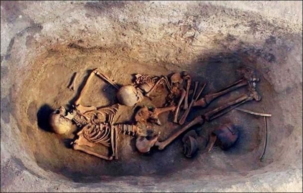
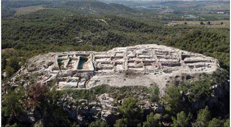
Bronze Age Burial Site of Powerful Woman Discovered Under the Ancient Palace in Spain
Archaeologists in Spain have determined that the 3,700-year-old remains of a woman found beneath a Bronze Age-era ruin may well be the first case of an ancient female ruling elite in Western Europe.
The discovery at the La Almoloya site in Murcia, Spain, dates to around 1,700 B.C., according to newly published research in the British journal Antiquity.
The woman’s potential status as a ruler also means that the ruin her body was buried beneath is likely the first palace found in Western Europe dating from the Bronze Age, which lasted from about 3,200 -1,200 B.C.
The Almoloya site was first discovered in 1944 and is believed to be the cradle of the El Argar society, which flourished between 2,200 and 1,550 B.C. in the southeast part of what is now Spain.
They were one of the first societies in the region to use bronze, build cities, and erect monuments. El Argar is also considered to be an early example of a class-based state, with divisions in wealth and labour.
The woman’s remains, discovered in 2014, were buried with a man and several valuable objects, most notably a rare silver crown-like diadem on her head.
Further analysis of the remains and artifacts over the last few years led researchers to their conclusions about the significance of the find.
“These grave goods have allowed us to grasp the economic and political power of this individual and the dominant class to which they belonged,” researchers said in a press release.
The remains of the woman and man were found in a large jar located beneath the floor of a room. Researchers believe the woman was 25-30 years old and the man was 35-40 when they died around the same time in the mid-17th century B.C.
Genetic analysis indicates they had children together, including a daughter buried elsewhere on the site.
But it was the valuable objects, and the diadem, in particular, that suggested the political importance of the woman.
Also significant was the location of the remains beneath a room in a large building complex that seems to have had both residential and political functions, including a room with benches that could hold up to 50 people that researchers nicknamed the ‘parliament’.
This combination of residential and political use means the building meets the definition of a palace and would make it the first discovery that dates from the Bronze Age in Western Europe.
“The La Almoloya discoveries have revealed unexpected political dimensions of the highly stratified El Argar society,” the researchers said.
The building was destroyed by fire not long after the woman was interred, they said.
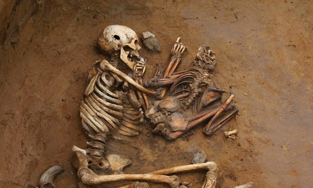
This Medieval Mother Had a Gruesome ‘Coffin Birth’ After Medieval Brain Surgery
Italian archaeologists have uncovered a medieval grave containing the remains of a woman buried near Bologna, Italy, with a 38-week-old fetus lying between her legs, reports said. Researchers believe the fetus “extruded after the burial” and called it an example of a “coffin birth,” Forbes reported.
The team from the Universities of Ferrara and Bologna said that the child’s leg bones possibly never made it out of the pelvic cavity, however, the upper torso and head likely did, meaning “the fetus was likely partially delivered.”
The mother’s skull showed a small, circular wound, likely caused during primitive brain surgery called trepanation
The mother’s skeletal remains showed a forehead cut and a 5-millimeter hole adjacent to that, likely intentionally drilled during a primitive skull surgery, according to the researchers.
Coffin birth, which the researchers said was the case in this specific case, is a phenomenon that takes place when a deceased pregnant woman’s fetus is expelled from the grave.
Around two to five days after the death of the pregnant woman, the phenomenon, also known as “postmortem fetal extrusion,” occurs following a build-up of gas pressure inside the body thus forcing the fetus to be ejected from the vaginal canal. Researchers said, in this case, the fetus had already died when the mother was buried.
The case in point was first uncovered back in 2010, when archaeologists found the strange Middle Ages burial in Imola, Italy.
A closeup of the skeleton’s pelvis reveals the bones of a partially-delivered fetus. This “coffin birth” likely occurred after posthumous gasses built up inside the dead mother’s body.
It suggested a proper, intentional burial, however, they also discovered a pile of bones below the pelvis of the skeletal remains of the woman. The woman’s skull had a hole in it making the scene further complicated.
Further investigation was then conducted by the researchers, the results of which have currently been published in the science journal World Neurosurgery.
According to the new research, the buried woman is believed to be somewhere between 25 and 35 years old when she died and was buried. The fetus was at 38 weeks of development (just two weeks less than the time of being full term).
The baby’s legs were said to be still inside the mother’s body, however, its head and upper body had dropped below the pelvic cavity. The fetus was already in its head-down orientation (the cephalic position) and was thus positioned for birth, the researchers explained.
The five-millimeter circular hole across her forehead suggests that she had undergone a procedure called trepanation- an ancient surgical procedure, which involves creating a hole in the skull by either scraping or drilling away layers of bone.
Female burial from near Bologna Italy (c. 7th c AD).
Trepanation was said to be used in the treatment of eclampsia — a hypertensive pregnancy disorder. The researchers proposed that the woman might have undergone skull surgery for this purpose.
“Historically, trepanation was used for treating several symptoms and disorders, such as cranial injuries, high intracranial pressure, convulsions, and high fever — all three of which are also caused by eclampsia,” Alba Pasini, a co-author of the study and a researcher from the Department of Biomedical and Specialty Surgical Sciences at University of Ferrara, said in an interview with Gizmodo.
“Scientific literature — both medical and archaeo-anthropological — attests that [these symptoms] were treated through trepanation from prehistory to the contemporary era.
We are sure, as reported in the paper, that this treatment did not heal the woman, since there are only the first signs of osteological reaction attesting the beginning of the healing process of the bone, indicating that the woman survived one week from the surgery at most,” Pasini added.
The woman, according to the researchers, lived for around one more week following the surgery, and had been buried while still pregnant, and thus that led to her having a coffin birth while her body decomposed, researchers concluded.
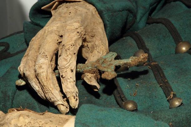
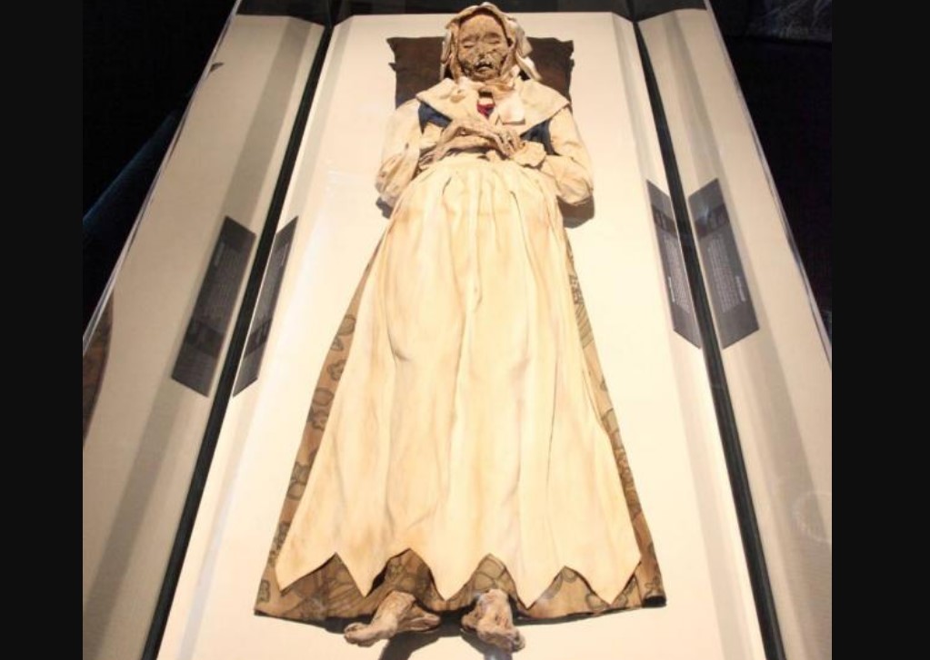
Jaw-Dropping Discovery: 18th-Century Mummified Monks Revealed Suffering From Tuberculosis Infections
Scientists recently examined tissue samples from tuberculosis-infected bodies that were naturally mummified in a church crypt in Vac, Hungary. Researchers found that tuberculosis that killed them in the 1700s derived from an ancestral strain of the bacteria dating from Roman times still circulating in Europe in the 18th century.
The bodies, excavated in 1994, were naturally mummified by extremely dry air and pine chips in coffins. The pine chips have natural antimicrobial agents and absorbed moisture.
The bodies had been buried in a church crypt between 1731 and 1838. They were Catholics, buried fully clothed, and many of them were rich, says an article in Phys.org. Their clothing too was preserved by the dry air.
The bodies and clothing of individuals placed in a church crypt in Vac were extremely well preserved.
Vac is just north of the Hungarian capital of Budapest. A construction worker in the Dominican church in Vac tapped on a wall and heard a hollow sound. He pulled out a brick and saw the caskets.
Experts found more than 200 bodies, 26 of which were tested because they had signs of tuberculosis infection. Eight of the bodies yielded tissue samples from which researchers were able to do genetic sequencing of the tuberculosis germs.
“What emerged is a tableau of a disease that fully lives up to its reputation in folklore,” wrote Phys.org. “TB was raging in 18th-century Europe, even before urbanization and crowded housing made it a killer on a much greater scale, the investigators found.”
Mycobacterium tuberculosis germs (U.S. Centers for Disease Control)
The German microbiologist Robert Koch was the first to describe Mycobacterium tuberculosis, in 1882. Koch said consumption, as people called it then, killed one in seven people. The disease is still a serious problem, but the World Health Organization reports deaths from it have been decreasing in recent decades.
In the church in Vac, the dead people’s names and how they died were recorded in documents. Phys.org said that makes the bodies a valuable resource for people who study diseases because the combination gives evidence about how TB and disease spread centuries ago.
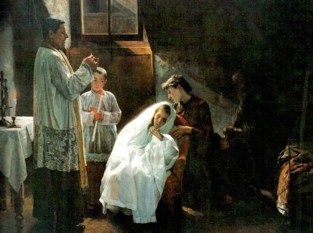
The First and Last Communion, an 1888 painting of a TB victim’s last rites, by Cristobal Rojas
“Microbiological analysis of samples from contemporary TB patients usually report a single strain of tuberculosis per patient,” Mark Pallen of the England’s University of Warwick medical school, told Phys.org.
Pallen was the chief researcher in the new study. “By contrast, five of the eight bodies in our study yielded more than one type of tuberculosis—remarkably, from one individual, we obtained evidence of three distinct strains.”
All eight bodies were carriers of a particularly virulent strain of tuberculosis called Lineage 4. Still today this strain infects more than 1 million people in the Americas and Europe per year.
“It confirmed the genotypic continuity of an infection that has ravaged the heart of Europe since prehistoric times,” Pallen said.
Researchers built a family tree of the TB bug and ascertained its bacterial ancestor dating to the late Roman period. This dating seems to lend credence to recent estimates that tuberculosis emerged in humans about 6,000 years ago, Phys.org said. Previous research theorized tuberculosis emerged in humans tens of thousands of years ago.
The Mummies of the World exhibition, presently at the Cincinnati Museum Center in the U.S. state of Ohio, has several mummies from the church in Vac, Hungary. This photo shows the body of Veronica Orlovits.
The World Health Organization reports that about one-third of humans are infected with tuberculosis bacteria, but only a small percentage will become ill from it.
In 2013, about 9 million people became sick with the disease worldwide. Approximately 95 percent of TB deaths are in middle- and low-income nations. While the disease is a serious problem, the threat from it appears to be decreasing somewhat.
“The number of people falling ill with TB is declining and the TB death rate dropped 45 percent since 1990. For example, Brazil and China have shown a sustained decline in TB cases over the past 20 years. In this period China has had an 80% decline in deaths,” WHO reports.
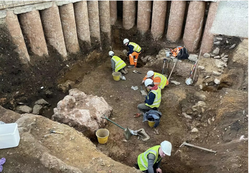
Roman-era altar stone has been discovered under Leicester Cathedral
The base of a Roman-era altar stone has been discovered under Leicester Cathedral, the first Roman altar stone ever found in Leicester.
The area was previously believed to be a garden space in the Roman city, but archaeologists from the University of Leicester Archaeological Service (ULAS) uncovered the remains of a Roman building in the northwest quarter of the site. Inside the cellar of this building was the base of an altar stone.
Archaeologists from the University of Leicester excavate a Roman cellar at Leicester Cathedral
This was not a plain subterranean storage room. The floor is concrete and the stone walls were painted. The quality of construction materials, the decorative paintwork and the presence of the altar indicates the room was a private shrine or otherwise devoted to religious worship.
The room dates to the 2nd century A.D. and was accessed by an external passageway with timber walls and a flagstone floor. The cellar was demolished and filled deliberately in the late 3rd or early 4th century.
The altar was found toppled face-down into the rubble layer. It was made of local sandstone from a quarry just one mile away and was decorated on three sides.
The back is plain, so it was probably originally placed against a wall. About half of it survives. Archaeologists estimate it would originally have been about two feet tall.
Mathew Morris, who led the dig, said the discovery of the Roman altar – the first to be found in Leicester – was “amazing”.
He added: “For centuries, there has been a tradition that a Roman temple once stood on the site of the present cathedral.
This folktale gained wide acceptance in the late 19th century when a Roman building was discovered during the rebuilding of the church tower.”
“Underground chambers like this have often been linked with fertility and mystery cults and the worship of gods such as Mithras, Cybele, Bacchus, Dionysius and the Egyptian goddess Isis.
Sadly, no evidence of an inscription survived on our altar, but it would have been the primary site for sacrifice and offerings to the gods, and a key part of their religious ceremonies.”
Leicester Cathedral was built in the heart of the medieval city at least as early as the 12th century and likely earlier than that.
The current building mostly dates to the 19th century when the church was extensively restored, but Leicester was a seat of a bishopric from 680 A.D. until the Saxon bishop was chased out of town by invading Danes in 870 A.D., so it’s likely there was a Saxon church predating the Norman cathedral.
As part of an ambitious restoration program complete with construction of a new Heritage Learning Centre, the old churchyard and gardens have been undergoing a comprehensive excavation since October 2021.
The excavation unearthed more than 1,100 burials dating from the end of the Saxon period in the 11th century to the middle of the 19th.
Radiocarbon dating of the earliest skeletal remains will narrow down the date range, and also confirm that the original parish church of St. Martin’s was founded in the late Saxon period.
Several pieces of Roman coins were also found
The remains are currently undergoing examination that archaeologists hope will shed new light on the lives and deaths of Leicester’s inhabitants over nearly 1,000 years. When the research project is concluded, all of the individuals will be respectfully reinterred by Leicester Cathedral.
Archaeologists have also discovered the remains of a structure believed to be from the Anglo-Saxon period. If the date is confirmed, this will be the first Anglo-Saxon structure ever found in this area of Leicester.
It will expand the known map of Anglo-Saxon occupation of the town after the end of Roman occupation. A silver penny from the period (880-973 A.D.) found near the structure is the first Anglo-Saxon coin found in Leicester in almost two decades.
Israel archaeologists find ancient comb with ‘full sentence’
It’s a simple sentence that captures the hopes and fears of modern-day parents as much as the bronze age Canaanite who owned the doubled-edged ivory comb on which the words appear.
Believed to be the oldest known sentence written in the earliest alphabet, the inscription on the luxury item reads: “May this tusk root out the lice of the hair and the beard.”
The double-duty ivory comb – bearing 14 teeth for lice and eggs and six bigger teeth for hair tangles – believed to have been made around 1700 BCE.
Unearthed in Lachish, a Canaanite city state in the second millennium BCE and the second most important city in the kingdom of Judah, the comb suggests that humans have endured lice for thousands of years and that even the wealthiest were not spared the grim infestations.
“The inscription is very human,” said Prof Yosef Garfinkel, an archaeologist at the Hebrew University of Jerusalem, who helped direct the Lachish excavations.
“You have a comb and on the comb you have a wish to destroy lice on the hair and beard. Nowadays we have all these sprays and modern medicines and poisons. In the past they didn’t have those.”
The comb, which measures 3.5cm by 2.5cm, was discovered at the site in south-central Israel in 2017, but the shallow engravings on the surface were only spotted in December last year.
Analysis of the markings confirmed the writing to be Canaanite script, the earliest alphabet, which was invented about 3,800 years ago.
Script taken from the comb, which was discovered in 2017
Efforts to obtain an age for the comb from carbon dating proved futile, but researchers believe it was made around 1700 BCE.
The comb is worn and has lost its teeth, but the remaining stumps show that it once bore six widely spaced teeth for removing hair tangles on one side, and 14 narrowly spaced teeth for removing lice and eggs on the other.
Further evidence for the comb’s purpose came when researchers examined it under a microscope and identified the tough outer membranes of half millimetre-long nymph stages of head lice.
The letters on the comb spell out seven words that form the first completely deciphered sentence in a Canaanite dialect, written in Canaanite script, said the researchers in the Jerusalem Journal of Archaeology.
Ancient combs were made from wood, bone and ivory, but the latter would have been expensive, imported luxuries. There were no elephants in Canaan at the time.
The world’s first writing systems originated in Mesopotamia and Egypt around 3200 BCE, but these were not alphabetic.
They relied on hundreds of different signs to represent words or syllables and as such required years to master, said Christopher Rollston, professor of northwest Semitic languages at George Washington University in the US.
Lachish, a leading Canaanite city state in the second millennium BCE.
The earliest alphabet was invented around 1800 BCE by Semitic-speaking people who were familiar with the Egyptian writing system, said Rollston.
Known as Canaanite or early alphabetic the system was used for hundreds of years, particularly in the Levant, and was standardised by the Phoenicians in ancient Lebanon.
It went on to become the foundation for ancient Greek, Latin and most modern languages in Europe today.
“The fact that this inscription is about ordinary life is especially fascinating,” Rollston said. “Throughout human history lice have been a perennial problem. And this inscription nicely reveals that even the rich and famous in ancient times were not exempt from such problems. We can only hope that this inscribed comb was useful in doing that which it says it was supposed to do – root out some of these pesky insects.”
This article was amended on 9 November 2022 to clarify in the headline that the discovery is not believed to be the oldest written sentence, but the oldest sentence written in the first alphabet. A reference to the site of the find being in south-central Israel was also added.
Ancient DNA Reveals History of Hunter-Gatherers in Europe
A pair of studies offering the most in-depth look into the lives of Ice Age hunter-gatherers has revealed at least eight previously unknown groups of early Europeans. Until recently, much about the earliest humans to populate Europe remained unknown.
Because few human fossils from those cultures remain, archaeologists have primarily had to reference early human artifacts to try and understand our Ice Age ancestors. Still, artifacts alone could not paint a clear image of how these ancient cultures were related or how they migrated.
All of that is changing now, thanks to a pair of studies, published in the journal Nature, examining the largest known database of prehistoric European hunter-gatherer genomes.
In total, researchers analyzed the genomes of 357 ancient Europeans who lived between 35,000 and 5,000 years ago — including new data from 116 individuals.
Using this data, they were able to identify at least eight populations of ancient hunter-gatherers who migrated into Europe and coexisted for thousands of years. Some of these groups managed to survive the Ice Age, while others did not.
A 7,000-year-old human skull and tools were found in Germany, by an individual whose population lived alongside Europe’s first farmers.
“We are finally understanding the dynamics of European hunter-gatherers,” Vanessa Villalba-Mouco, a paleogeneticist at the Max Planck Institute for Evolutionary Anthropology in Leipzig, Germany, and an author of both studies, told The New York Times.
Prior to the emergence of DNA analysis, researchers identified ancient humans by the things they made — certain tools or art, for example. This is how Europe’s oldest modern human culture, the Aurignacians, earned its name, from the figurative cave paintings and sculptures it produced.
Then, around 33,000 years ago, Europe’s climate cooled and a new human culture is known as the Gravettian spread across the continent. These were the ancient humans known for hunting woolly mammoths with spears and crafting Venus figurines.
But as scientists analyzed Gravettian DNA from across Europe, they came to the startling realization that they were looking at two distinct genetic populations. The first population, named the Fournol, came from France and Spain; the other, the Vestonice, came from Italy, the Czech Republic, and Germany.
They observed that the Fournol people shared a genetic link with 35,000-year-old Aurignacian remains found in Belgium and that the Vestonice people likewise shared a link with 34,000-year-old populations in Russia.
And though these groups were genetically distinct, there is evidence that they interacted and shared tools and culture with one another. In fact, 30,000-year-old remains discovered in Belgium show a mix of Fournol and Vestonice ancestry.
These early Europeans, however, don’t have much, if any, of a genetic link to the younger hunter-gatherers who eventually split into the ancestors of living Europeans and Asians.
Until now, the general understanding of human migration suggested that modern humans arose in Africa and began to expand across other continents around 60,000 years ago. We can see the disappearance of Neanderthals about 40,000 years ago, with many believing they had been unable to compete with Homo sapiens’ superior tools.
But this new research suggests that story might not be entirely accurate. Modern humans may not have simply arrived in Europe, dominated and outcompeted Neanderthals, and continued onward. In fact, it seems as if the first modern humans in Europe, whose DNA dates back 45,000 years, disappeared along with the Neanderthals.
“It’s actually quite interesting that the very first modern humans also had a very hard time to actually survive,”said Cosimo Posth, a paleogeneticist at the University of Tübingen in Germany and an author on both studies.
When the Ice Age began around 26,000 years ago, these early human populations faced a massive threat — and as a result, they could not survive on much of the European continent. This is where we start to see other major splits in human populations.
“Right after the Last Glacial Maximum, the genetic makeup of the human groups living in the Italian peninsula changed dramatically,” Ludovic Orlando, a molecular archaeologist who wrote a perspective on the new study, told Live Science.
In southern regions, such as the Iberian Peninsula (modern-day Spain and Portugal), the Fournol found refuge from the massive ice walls that dominated the rest of Europe. DNA analysis of a 23,000-year-old human found in a Spanish cave shows that he belonged to the Fournal people residing there before the Ice Age.
As the Ice Age came to an end and much of the ice began melting away, some Fournol descendants left the Iberian Peninsula and spread out, while others remained. Post and his colleagues referred to this northbound population as the GoyetQ2.
There is no evidence, however, to suggest that the Vestonice survived the Ice Age. While they may have survived for a time in Italy, there is no Vestonice ancestry found in any Europeans after the Ice Age. Rather, a new population known as the Villabruna expanded into Europe from the Balkans and effectively replaced the Vestonice.
An artist’s depiction of a Vestonice hunter-gatherer.
For a time, the GoyetQ2 and the Villabruna were kept at a distance, in large part because of the Alps. Then, around 14,000 years ago, the Villabruna crossed the Alps and came into contact with the GoyetQ2 — and from this meeting, a new population emerged, known as the Oberkassel.
The Oberkassel then expanded across Europe and replaced the GoyetQ2. Post noted that this coincided with another major climate shift around 14,000 years ago that saw the continent warm and produce bountiful forests. It’s possible that the Oberkassel were better suited to hunting in these forests, which could explain why they replaced the GoyetQ2.
From the east, another group emerged, the Sidelkino, whose descendants lived in Ukraine and surrounding regions. The Oberkassel and the Sidelkino encountered one another, but the Iberians remained largely separate from other human groups. The Villabruna, meanwhile, ventured north and merged with the population of northern Spain, rather than replacing them.
Then, the first farmers arrived in Europe from modern-day Turkey around 8,000 years ago. Researchers found that the remaining populations of hunter-gatherers began mixing as they were introduced to agriculture, and were eventually absorbed into the agricultural communities that began dominating Europe.
This new research “considerably extends our knowledge of ancient genome human variation in the deep past of Europe,” Orlando said. “It unveils important changes in the genetic makeup of some regions following major climate changes.”
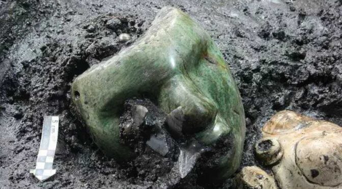
2,000-Year-Old Realistic Green Mask Found Nestled Inside an Ancient Pyramid
Mexico has many remarkable archaeological sites that provide insight into its pre-Columbian history. Among the most impressive structures is the Pyramid of the Sun, which continues to reveal amazing discoveries.
Built approximately in 100 CE, this pyramid is the largest structure in Teotihuacan and has been under continuous research by archaeologists.
Although few artifacts have been unearthed on-site, in 2011,researchers from Mexico’s National Institute of Anthropology and History (INAH) made a surprising discovery using a 380-foot-long tunnel excavated by archaeologists in the 1930s.
By using the tunnel, the team was able to reach the mother-rock level. Upon arrival, they discovered a valuable assortment of artifacts, such as fragments of clay pottery, animal bones, obsidian pieces, three serpentine human figurines, and a remarkable “Green” serpentine mask. The green mask holds significant interest as, during its unearthing, it was the sole mask of its type discovered in a ritual context in Teotihuacan.
According to a statement by INAH, the discovery comprises 11 ceremonial clay pots dedicated to a rain god resembling Tlaloc. The findings also included animal bones, such as rabbits fed to eagles, and feline and canine remain yet to be identified.
These offerings were placed on a rubble base where the temple was built around 50 AD. It is noteworthy that Tlaloc was still revered in the region even after 1,500 years.
These offerings were believed to be deposited as part of a ritual to inaugurate the pyramid’s construction, which explains their location at the lower level. The discovery of this mask was particularly noteworthy because it depicted a human face with remarkable accuracy and simplicity.
This is significant due to the importance of masks in indigenous people’s religious practices. The Aztecs, in particular, were a culture that placed great value on masks, as noted by renowned anthropologist Claude Lévi-Strauss.
There are numerous types of masks, both intended for wear and crafted as miniature versions, possibly for use as amulets. With a history of mask-making in the region spanning millennia, ranging from rudimentary pottery to intricate art pieces, the diversity of masks would have been remarkable, given their various shapes and forms.
Unfortunately, only a limited number of masks have been discovered despite the estimated abundance of them, but the depictions of masks throughout history strongly suggest that many more existed over the centuries.
The Pyramid of the Sun, known today as the world’s third-largest pyramid, was named by the Aztecs who visited Teotihuacan centuries after its abandonment. The original name of the pyramid remains a mystery.
Teotihuacan was once a flourishing city known as the City of the Gods, with a population of 200,000 at its peak. However, researchers have yet to learn about the people who inhabited this city and why they disappeared.
In the Aztec culture, masks played an essential role in religious ceremonies as they were meant to represent one of their many gods. The Aztecs were known for their artistic skills and colorful masks.
However, the few masks discovered so far had strong symbolism, such as animal features or distorted proportions compared to humans.
Some scholars suggest that individuals did not wear masks during their duties. Instead, they were placed on holders or over a skull, sent as tokens to other rulers and chiefs, or used as death masks.
This might explain why some masks were not carved out to allow the wearer to see. Despite this, most of the masks showed some elaboration or alteration of the human figure.
Masks have played a central role in the religion and rituals of Mesoamerican civilizations for millennia. Therefore, finding a mask resembling a buried person is unique.
New archaeological findings in the future may shed more light on this discovery, the site at large, and the beautiful Mesoamerican cultures.
Sitting to the north-east of Mexico City, Teotihuacan is one of Mexico‘s most visited ancient architectural sites.
The National Institute of Anthropology and History (INAH) has been researching to uncover more information about the ancient civilization of Teotihuacán.
One of the recent discoveries made by INAH was an underground tunnel found beneath the Pyramid of the Moon. The use of electrical resistance technology enabled the mapping of the tunnel without the need for ground excavation.
The tunnel leads to an underground chamber, preceded by a chamber measuring 49 feet in diameter. This newly discovered chamber may hold more treasures. The accumulation of these findings will hopefully provide more insight into the civilization of Teotihuacán and reveal more information about its decline.
Verónica Ortega, the director of the Integral Conservation Project for the Plaza of the Moon, explains that the large offering complexes constitute the sacred heart of Teotihuacan, making it a mecca for civilization.
The discoveries made within these complexes can help to unravel the relationship that the ancient metropolis had with other regions of Mesoamerica.