1000 Ancient Sites Revealed by Aerial Scan of Scotland’s Arran Island
Archaeologists in Scotland have concluded a cutting-edge archaeological project which has revealed around 1,000 previously unknown archaeological sites on the Isle of Arran.
There is an island off the coast of Scotland which contains some of northern Europe’s most spectacular standing stones, megalithic tombs, and ruins of ancient farming communities going back around 6,000 years.
I am not talking about Orkney or Shetland but another magical island only a short ferry crossing from Glasgow on Scotland’s west coast, which according to an Island Review article is more famous for its moors and mountains, arts and crafts, beer and whisky, than for its glorious prehistoric archaeology.
I am of course are speaking about the Isle of Arran in the Firth of Clyde where archaeologists from Historic Environment Scotland (HES) recently flew airborne laser scanning (lidar) devices over the land surface to generate a 3D image of prehistoric settlements, medieval farmsteads, and even a Neolithic monument, which the BBC called an “exceptionally rare find.”
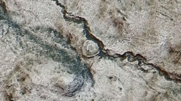
The remains of a hut circle became clear from the LIDAR scanning results.
LIDAR and the Rise Of “Rapid” Archaeology
The lidar data is available from the Scottish Government Remote Sensing Portal and the survey results are available to view on Canmore – Scotland’s National Record of the Historic Environment. It was the largest survey of its type that has ever been conducted.
Dave Cowley, Rapid Archaeological Mapping Manager at Historic Environment Scotland ( HES) said it has shown scientists that there are “double” the number of ancient monuments on the Isle of Arran than they had previously known about and Scottish heritage leaders say “tens of thousands” of further sites might be found using the scanning technology.
Cowley also told reporters that the new 3D technology allowed for a “rapid” archaeological survey conducted over weeks rather than months or years, and it also allowed the discovery of sites that might even have been impossible to find.
Among the structures identified from the air are medieval and post-medieval shielings (circular stone structures which sheltered sheep from winds), which detail how upland areas were used by shepherds.
Post-medieval shielings were identified for the first time with LIDAR.
Furthermore, archaeologists identified a magnificent medieval roundhouse – a type of circular wooden home with a conical roof that was built in Britain from the Bronze Age throughout the Iron Age and into the medieval period .
Mesolithic Pitchstone Traders
The Isle of Arran is the largest island in the Firth of Clyde and the seventh largest Scottish island . It is often referred to as a “geologist’s paradise,” and as far back as the Neolithic, and the Early Bronze Age, pitchstone from the Isle of Arran were transported around Britain.
According to a study published on Researchgate, worked Arran pitchstone from radiocarbon-dated pits indicate that on the Scottish mainland all archaeological pitchstone derives from outcrops on the Isle of Arran.
And on the island, pitchstone-bearing assemblages include diagnostic types from the Mesolithic that was traded extensively throughout Britain during the Early Neolithic period.
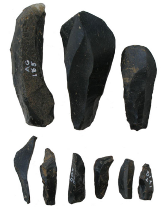
Pitchstone blades and microblades from Auchategan, Argyll & Bute
The Isle of Arran – An Ancient Spiritual Center
On Arran, archaeologists find a type of burial structure classified as a ‘Neolithic Clyde Cairn’ which are stone and earth mounds that enclose a chamber lined with larger stone slabs. They are thought to have been used for public community rituals.
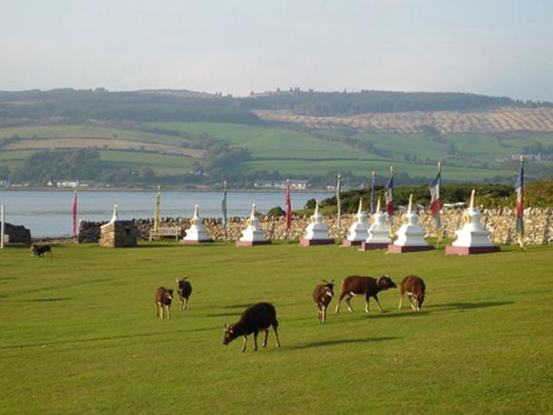
Several Bronze Age sites have been excavated and the monastery of Aileach was founded by St. Brendan in the 6th century with the nearby Holy Isle being a center of his spiritual activities. Holy Isle has a long history as a sacred site of pilgrimage with its healing holy well , 6th century monk St Molaise’s hermit cave, and a 13th-century monastery.
ome of the Soay sheep that live wild on Holy Isle in the Firth of Clyde, Scotland, are seen grazing by the Buddhist stupas which line the approach to the Centre for World Peace and Health.
Lidar technology is quickly building a new picture of Scotland’s historic environment and the new study on Arran is another step as the aerial scanning technology becomes more widely available.
And if the scientists’ speculations are right, and “ tens of thousands more ancient sites ” are discovered across the rest of Scotland, a whole new generation of archaeology, and archaeologists, will be attracted to the Highlands of Scotland.
Mystery messages engraved in Scotland’s rocks up to 5,000 years ago might soon be decoded using 3D scans
About 6,000 rocks that display distinctive “cup and ring” carvings, alongside other ancient engravings, dot the landscape of Britain, with at least one-third of them found in Scotland. Archaeologists have offered several explanations as to what these strange symbols mean. Some have said the ancients inscribed them for ritual ceremonies.
Others believe the carvings served much more practical purposes, that possibly these were territorial markers on ancient trade routes or mapped the stars in the sky.
However, in the words of George Currie, an amateur archaeologist who discovered some 670 rock carvings in Scotland, “many have symbolism that dates back thousands of years and we know little about why they were created.”
A spokesperson from Historic Environment Scotland (HES) noted that “the purpose and significance of rock art to prehistoric and more recent communities is poorly understood.” In 2022, HES was awarded £807,000 (around $1.1 million in U.S. dollars) by the Arts and Humanities Research Council to carry out a five-year-long project to reestablish this lost link to Scotland’s prehistoric past.
Cup and ring marks, Source: Historic Environment Scotland
We may never discover the full meanings of the engravings, but the project, making use of 3D scanners, will seek answers by documenting and analyzing a great number of rock carving examples. A result is expected probably by 2021: a database with 2D and 3D models of some of the decorated stones will be created, and perhaps some theories will follow too.
Experts from both the University of Edinburgh and the Glasgow School of Art are involved in the project activities, and scanning is expected to reveal new connections between the symbols, previously overlooked, between the rock carvings. Some are said to go as far back as to the Neolithic days.
Currie has also been invited to participate in the activities. Over a period of more than a decade, he has managed to discover, photograph, and GPS locate 670 rocks alone. While cups and rings are among the most recurring symbols of all, there are others that appear frequently, such as horseshoe shapes or some that remind of human footprints.
The Achnabreck Cup-and-Ring-Marked Rock. Source: Historic Environment Scotland
In statements in Mail Online, Currie, who comes from Dundee, said that “the idea is to cover the whole of Scotland to record all of the rock art in 3D where ever possible.” However, he remarks, challenges are certain to haunt the team as it is uncertain how scanning equipment will be brought to some of the locations of interest. Not all rocks are laid to rest in favorable terrains.
Potentially, the project could answer many other questions, such as why people have revisited the rocks, inscribing new symbols over rocks that had already had engravings. Meanwhile, new findings of rock carvings are still being encountered, with one major discovery of a “previously unrecorded example” being reported by BBC Scotland Highlands and Islands reporters in 2014.
Archaeologists stumbled upon new rock art with cup and ring engravings while trying to relocate one rock in the county of Ross-shire. As they examined the rock, the team was dazzled by corresponding marks on the other side of the rock as well. The discovery counted as a rare find.
Cup and ring marks survive in large numbers from Scotland and have offered a variety of meanings.
Although Britain is the focus of the interest in cup and ring rock carvings, these symbols are not exclusively found only on the island. Differing from place to place, examples have been documented overseas, with many being located in Ireland and Scandinavia, one example being Hartola, Finland, where researchers point out that the cup markings are notably wider compared to the Scottish ones.
More can be seen in the Italian region of Piedmont, but also across Switzerland, on Sardinia, or in Israel. Similar forms can be seen as far away as Gabon and Australia.
The native Picts, a Celtic-language speaking tribe, once populated the Scottish Islands, similar to the natives that live on what is now Scotland.
Archaeologists and volunteers are working to preserve human bones exposed by recent storms in an ancient cemetery above a beach on the Orkney Islands.
Several powerful storms on Scotland’s Orkney Islands have now revealed ancient human remains in a Pictish and Viking cemetery dated back to about 1,500 years ago.
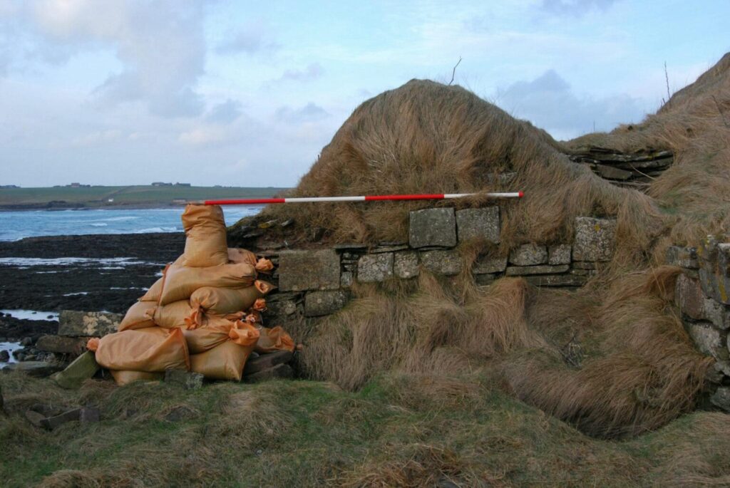
To order to protect the damage to the former Newark Bay cemetery on Orkney’s largest island, volunteers are now placing sandbags and clay around. The site dates from the middle of the sixth century when ancient Pictish people inhabited the Orkney Islands.
The site is currently being protected by sandbags.
Picts or Norse?
The cemetery was used for about 1,000 years, and numerous burials from the ninth to the 15th century were Norsemen or Vikings who had seized the Orkney Islands from the Picts. Now, storm waves are destroying the low cliff where the ancient site is located, Peter Higgins from the Orkney Research Center for Archaeology (ORCA), said.
“Every time we have a storm with a bit of a south-easterly [wind], it really gets in there and actively erodes what is just soft sandstone,” Higgins explained.
Approximately 250 skeletons were taken out of the cemetery about 50 years ago, but researchers do not know how far the site extends from the beach. They believe that hundreds of Pictish and Norse bodies are still buried there.
“The local residents and the landowner have been quite concerned about what’s left of the cemetery being eroded by the sea,” Higgins said.
Uncovered bones are usually either coated with clay to protect them or removed from the site after their positions are thoroughly labeled, so it is rather unusual for bones to end up on the beach, he explained.
Researchers do not know yet of the exposed bones belong to Picts or Vikings, as no burial objects or funeral clothes were spotted, and the bodies were buried four of five layers under the surface.
Cultural Transition
Historians claim that the first Norse immigrants to the Orkney Islands established there in the late eighth century, leaving a rising new monarchy in Norway. They used the Orkney Islands to begin their own voyages and Viking raids, and ultimately, all the islands were ruled by the Norse, according to The Scotsman.
The relationship between the Picts and the Norse on the Orkney Islands is highly argued by scholars. They cannot know for sure whether the Norse took over by force, or were settlers who traded and entered marriage with the Picts. However, now, the ancient cemetery at Newark Bay may help researchers answer their questions.
“The Orkney Islands were Pictish, and then they became Norse,” Higgins said. “We’re not really clear how that transition happened, whether it was an invasion, or people lived together. This is one of the few opportunities we’ve got to investigate that.”
A part of the scientific work on the remains would require testing genetic material from the ancient bones, which might demonstrate that some people living on the Orkney Islands today are successors of people who lived there more than 1,000 years ago.
The scientific study of bones from the ancient cemetery at Newark Bay could reveal clues to the cultural transition from Pictish to Norse domination of the Orkney Islands.
“We’re fairly confident that we’re going to find that some local residents are related to people in the cemetery,” Higgins said.
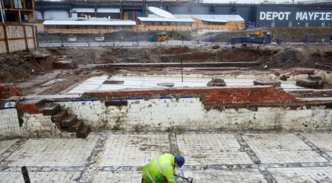
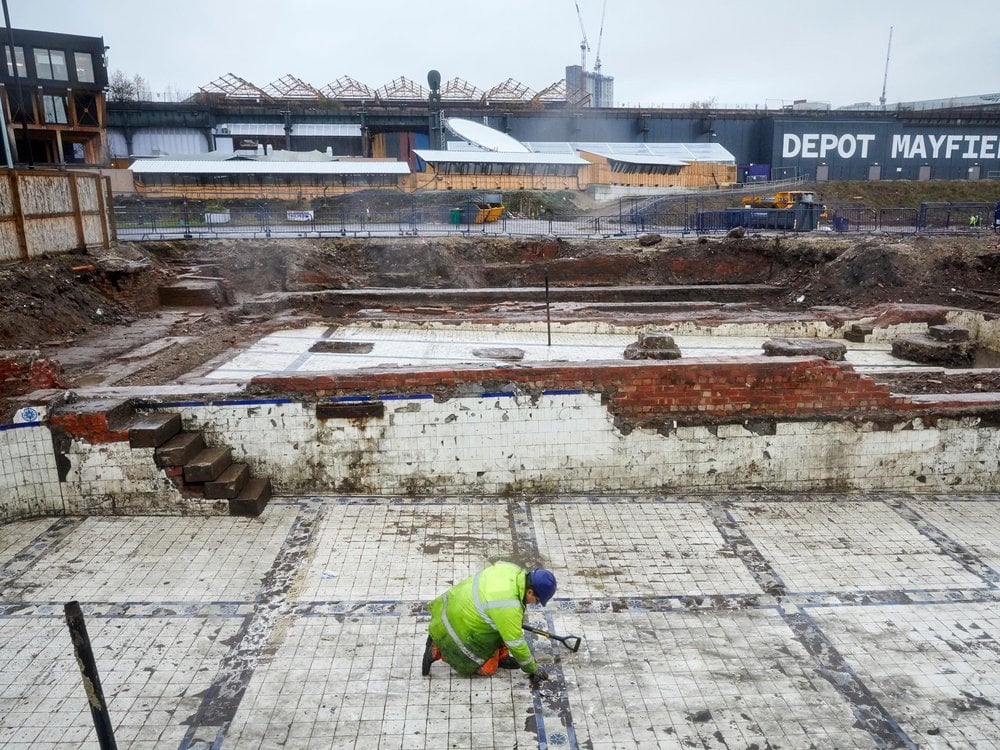
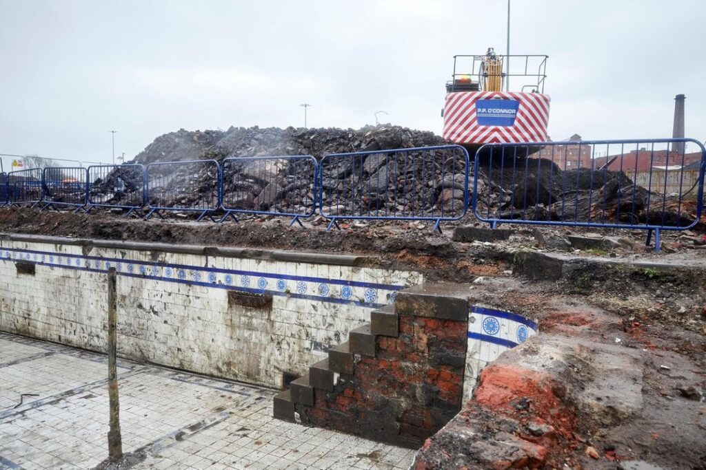
‘Stunning’ Victorian Bathhouse Unearthed Beneath Manchester Parking Lot
The facility offered laundry and bathing services for 19th-century textile workers and their families.
The baths featured both male and female pools, as well as laundry facilities.
Ahead of construction of a new public park, archaeologists in Manchester, England, have uncovered a bathhouse used by textile factory workers more than 150 years ago.
“We knew what we would be excavating but we didn’t expect the tiles to be in such good condition,” Graham Mottershead, project manager at Salford Archaeology, tells BBC News. “[T]hey are stunning.”
As Louise Rhind-Tutt reports for I Love Manchester, the baths opened in 1857, offering much-needed bathing and laundry services for workers during the city’s heyday as a center of industrial textile production. The facility included male and female pools, the largest of which measured 62 feet.
So far, researchers have uncovered two large tiled pools, boilers, flues and pumps. The mechanical systems heated water and circulated it through both the bathing and laundry facilities.
To uncover the baths’ details, archaeologists are using 3-D laser scanning and drone photography, in addition to physical excavation. The team will preserve these digital records alongside historical documents, allowing for the creation of accurate representations of the facilities.
“The sheer pace of change and innovation during the Industrial Revolution means many advancements were not recorded,” says Mottershead in a statement.
“Excavations like this help us to learn a great deal about what is arguably the most important period of human history and, in the case of Mayfield, a location that is so very relevant to the heritage of the people of Manchester.”
The researchers said the condition of the uncovered bathhouse tiles was “stunning.”
A history provided by the development company explains that the Mayfield area of Manchester became an important industrial center after businessman Thomas Hoyle established the Mayfield Print Works there in 1782.
By the mid-19th century, the neighborhood had won fame for its impressively quick printing of patterned textiles. At the time, Manchester as a whole was known as “Cottonopolis”—a reflection of its centrality to cloth production.
The Mayfield Baths were the third public baths built in the city. Ian Miller, an archaeologist at the University of Salford, tells BBC News that baths began as an amenity for the middle class in the 18th century but were followed by public facilities oriented toward the hygienic needs of industrial workers and their families. The city’s first public baths opened in 1846. Later, more were built, reaching a peak of 30 across the city by the late 19th century.
“Before public baths the textile workers lived in crammed insanitary conditions and would wash their clothes in the used bath water,” Miller says. “Public baths were a game changer for the health of the working classes, keeping clean and having clean clothes were essential for public health.”
The Guardian’s Josh Halliday reports that the facility remained standing until World War II, when it was damaged by bombing. It was later demolished.
More recently, the area, located behind Manchester Piccadilly station, went largely unused. The planned 6.5-acre Mayfield Park will be the first new public park built in the city in 100 years.
Per I Love Manchester, the excavation is part of an enormous effort by the Mayfield Partnership to redevelop a large section of the English city. In addition to the park, the plan includes the construction of 1,500 homes and nearly two million square feet of commercial, retail and leisure space.
One of the commercial buildings will be named after George Poulton, a 19th-century competitive swimmer and public health advocate who gave swimming lessons at the Mayfield Baths and educated the public about hygiene. The design of the building’s foyer will echo the baths’ appearance.
Face of ‘ordinary poor’ man from medieval Cambridge graveyard revealed
New facial reconstruction of a man buried in a medieval hospital graveyard discovered underneath a Cambridge college sheds light on how ordinary poor people lived in medieval England.
The audience of an event at this year’s Cambridge Science Festival found themselves staring into the face of a fellow Cambridge resident – one who spent the last 700 years buried beneath the venue in which they sat.
The 13th-century man, called Context 958 by researchers, was among some 400 burials for which complete skeletal remains were uncovered when one of the largest medieval hospital graveyards in Britain was discovered underneath the Old Divinity School of St John’s College, and excavated between 2021 and 2022.
The bodies, which mostly date from a period spanning the 13th to 15th centuries, are burials from the Hospital of St John the Evangelist which stood opposite the graveyard until 1511, and from which the College takes its name. The hospital was an Augustinian charitable establishment in Cambridge dedicated to providing care to members of the public.
“Context 958 was probably an inmate of the Hospital of St John, a charitable institution which provided food and a place to live for a dozen or so indigent townspeople – some of whom were probably ill, some of whom were aged or poor and couldn’t live alone,” said Professor John Robb, from the University’s Division of Archaeology.
The face of Context 958. Credit: Dr. Chris Rynn, University of Dundee
In collaboration with Dr Chris Rynn from the University of Dundee’s Centre for Anatomy and Human Identification, Robb and Cambridge colleagues have reconstructed the man’s face and pieced together the rudiments of his life story by analysing his bones and teeth.
The work is one of the first outputs from the Wellcome Trust-funded project ‘After the plague: health and history in medieval Cambridge’ for which Robb is principle investigator. The project is analysing the St John’s burials not just statistically, but also biographically.
“Context 958 was over 40 when he died, and had quite a robust skeleton with a lot of wear and tear from a hard working life. We can’t say what job specifically he did, but he was a working class person, perhaps with a specialised trade of some kind,” said Robb.
“One interesting feature is that he had a diet relatively rich in meat or fish, which may suggest that he was in a trade or job which gave him more access to these foods than a poor person might have normally had. He had fallen on hard times, perhaps through illness, limiting his ability to continue working or through not having a family network to take care of him in his poverty.”
Facial reconstruction of Context 958. Credit: Dr. Chris Rynn, University of Dund
There are hints beyond his interment in the hospital’s graveyard that Context 958’s life was one of adversity. His tooth enamel had stopped growing on two occasions during his youth, suggesting he had suffered bouts of sickness or famine early on. Archaeologists also found evidence of a blunt-force trauma on the back of his skull that had healed over prior to his death.
“He has a few unusual features, notably being buried face down which is a small irregularity for medieval burial. But, we are interested in him and in people like him more for ways in which they are not unusual, as they represent a sector of the medieval population which is quite hard to learn about: ordinary poor people,” said Robb.
“Most historical records are about well-off people and especially their financial and legal transactions – the less money and property you had, the less likely anybody was to ever write down anything about you. So skeletons like this are really our chance to learn about how the ordinary poor lived.”
The focal point of the ‘After the Plague’ project will be the large sample of urban poor people from the graveyard of the Hospital of St John, which researchers will compare with other medieval collections to build up a picture of the lives, health and day-to-day activities of people living in Cambridge, and urban England as a whole, at this time.
Dr Sarah Inskip examines the skull of Context 958.
“The After the Plague project is also about humanising people in the past, getting beyond the scientific facts to see them as individuals with life stories and experiences,” said Robb.
“This helps us communicate our work to the public, but it also helps us imagine them ourselves as leading complex lives like we do today. That’s why putting all the data together into biographies and giving them faces is so important.”
The Old Divinity School of St John’s College was built in 1877-1879 and was recently refurbished, now housing a 180-seat lecture theatre used for College activities and public events, including last week’s Science Festival lecture given by Robb on the life of Context 958 and the research project.
The School was formerly the burial ground of the Hospital, instituted around 1195 by the townspeople of Cambridge to care for the poor and sick in the community. Originally a small building on a patch of waste ground, the Hospital grew with Church support to be a noted place of hospitality and care for both University scholars and local people.
ontext 958 buried face-down in the cemetery of St John’s.
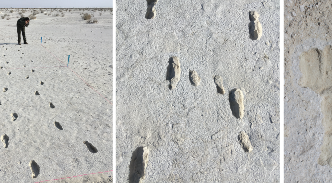
10,000-year-old footprints show journey of squirmy toddler and caregiver
The footprints found at White Sands National Park are more than 10,000 years old.
A small woman—or perhaps an adolescent boy—walks quickly across a landscape where giant beasts roam. The person holds a toddler on their hip, and their feet slip in the mud as they hurry along for nearly a mile, perhaps delivering the child to a safe destination before returning home alone.
Despite the fact that this journey took place more than 10,000 years ago, a new paper published in the journal Quaternary Science Reviews manages to sketch out what it might have looked and felt like in remarkable detail.
Evidence of the journey comes from fossilized footprints and other evidence discovered in New Mexico’s White Sands National Park in 2022, reports Albuquerque TV station KRQE.
Toward the end of the late Pleistocene epoch—between 11,550 and 13,000 years ago—humans and animals left hundreds of thousands of tracks in the mud along the shore of what was once Lake Otero.
The new paper investigates one specific set of tracks, noting details in the footprints’ shapes that reveal how the traveler’s weight shifted as they moved the child from one hip to the other.
“We can see the evidence of the carry in the shape of the tracks,” write study co-authors Matthew Robert Bennett and Sally Christine Reynolds, both of Bournemouth University in England, for the Conversation.
“They are broader due to the load, more varied in morphology often with a characteristic ‘banana shape’–something that is caused by outward rotation of the foot.”
At some points along the journey, the toddler’s footprints appear as well, most likely because the walker set the child down to rest or adjust their position. For most of the trip, the older caretaker carried the child at a speed of around 3.8 miles per hour—an impressive pace considering the muddy conditions.
“Each track tells a story: a slip here, a stretch there to avoid a puddle,” explain Bennett and Reynolds. “The ground was wet and slick with mud and they were walking at speed, which would have been exhausting.”
In this artist’s depiction, a prehistoric woman holding a child leaves footprints in the mud.
On the return trip, the adult or adolescent followed the same course in reverse, this time without the child. The researchers theorize that this reflects a social network in which the person knew that they were carrying the child to a safe destination.
“Was the child sick?” they ask. “Or was it being returned to its mother? Did a rainstorm quickly come in catching a mother and child off guard? We have no way of knowing and it is easy to give way to speculation for which we have little evidence.”
The fossilized footprints show that at least two large animals crossed the human tracks between the outbound and return trips. Prints left by a sloth suggest the animal was aware of the humans who had passed the same way before it.
As the sloth approached the trackway, it reared up on its hind legs to sniff for danger before moving forward. A mammoth who also walked across the tracks, meanwhile, shows no sign of having noticed the humans’ presence.
White Sands National Park contains the largest collection of Ice Age human and animal tracks in the world. As Alamogordo Daily News reports, scientists first found fossilized footprints at the park more than 60 years ago. But researchers only started examining the tracks intensively in the past decade, when the threat of erosion became readily apparent.
The international team of scientists behind the new paper has found evidence of numerous kinds of human and animal activity. Tracks testify to children playing in puddles formed by giant sloth tracks and jumping between mammoth tracks, as well as offering signs of human hunting practices.
Researchers and National Park Service officials say the newest findings are remarkable partly for the way they allow modern humans to relate to their ancient forebears.
“I am so pleased to highlight this wonderful story that crosses millennia,” says Marie Sauter, superintendent of White Sands National Park, in a statement. “Seeing a child’s footprints thousands of years old reminds us why taking care of these special places is so important.”
Built Before Stone Henge: Mount Pleasant One of Five Known Mega Henges in Southern England
Mega Henges: Many of us were taught that the Stone Age was filled with hairy cavemen who didn’t have a lot going for them. In fact, the many henges around England attest to the building skills of Neolithic people and at about 2500BC, just before Europeans arrived in Britain, even had a big construction boom.
There are five mega henges in southern England including a henge at the Mount Pleasant Neolithic site near Dorchester, Dorset.
It was built before Stonehenge and consists of a large circle where people went for rituals with large stones and perhaps a wooden structure in the center.
Mount Pleasant Henge dig in the 1970s
A wooden fence made from tree trunks surrounded the henge as well as a bank and a ditch according to theguardian.com. The size of the round concentric henge is enormous, almost sixty two thousand square feet and it was built entirely by people using deer antlers as digging tools.
The Mount Pleasant Neolithic site was first excavated in the early 1970s and researchers believe the time to build the site took anywhere from thirty five years to one hundred and twenty five years with multiple descendants taking over the work but now they suggest it was built WITHIN 35 years.
Mount Pleasant Henge crop marks.
According to lead researcher and lead author of a research paper Tempo of a Mega-henge: A New Chronology for Mount Pleasant, Dorchester, Dorset found at cambridge.org, Susan Greaney of Cardiff University’s School of History, Archaeology and Religion remarked, “The building of Mount Pleasant would have involved a huge number of people digging out the enormous ditches with simple tools like antler picks.
Stone age antler pick found at Mount Pleasant
This was right at the end of the stone age, just before people came from the continent with metal goods, new types of pottery, new styles of burial and so on…” Because dating objects was no where near as effective in 1970, archeologists have been able to use radiocarbon dating to determine that it was probably built in the 26th century BC.
The other mega henges in southern England include Marden Henge, the largest found to date at forty acres which was surrounded by a fence of ten foot tall tree trunks.
Merden Henge
According to nationalgeographic.com, Jim Leary, director of the archaeology field school at the University of Reading, partnered with Historic England and launched a three-year excavation of Marden Henge in 2022.
Artifacts such as an early Bronze Age burial, arrowheads for exhibition rather than hunting and the remains of over thirteen pigs which were most likely cooked and eaten there were discovered. The burial was that of a teenager interred with an amber necklace about four thousand years a
Tells us of a mega henge discovered about two miles from Stonehenge and fifteen times larger beneath the banks of Durrington Walls.
In the foreground is the southern wall of Durrington Walls, a prehistoric site near to Durrington in Wiltshire. In the background of the image is the western wall of the site.
The stones stood almost fifteen feet tall before they were damaged over four thousand years ago when they were buried to form earthen embankments to surround the site. The henge is surrounded by a fifty eight foot long ditch that takes up a mile of land around the henge.
According to megalithic.co.uk, a stone circle in Wiltshire was discovered in 1999 and owns the title for the largest henge circle in the world. The surrounding embankment is almost a full mile long and the inside area is just over twenty eight acres. It is estimated that it took 1.5 million man hours to construct.
Silbury Hill in Avebury, while not a henge in the traditional way, is a part of the Stonehenge complex and is believed to have been built around 2400BC.
It is an artificial mound equal to the size of the Egyptian pyramids but no one knows its original purpose. There are no burials and the mound is just dirt and chalk.
More materials were added over the years adding to the height and the ditch enclosing the mound shows evidence of backfilling and cutting.
On three separate occasions the hill was excavated with tunnels running horizontally and vertically with nothing of interest found.
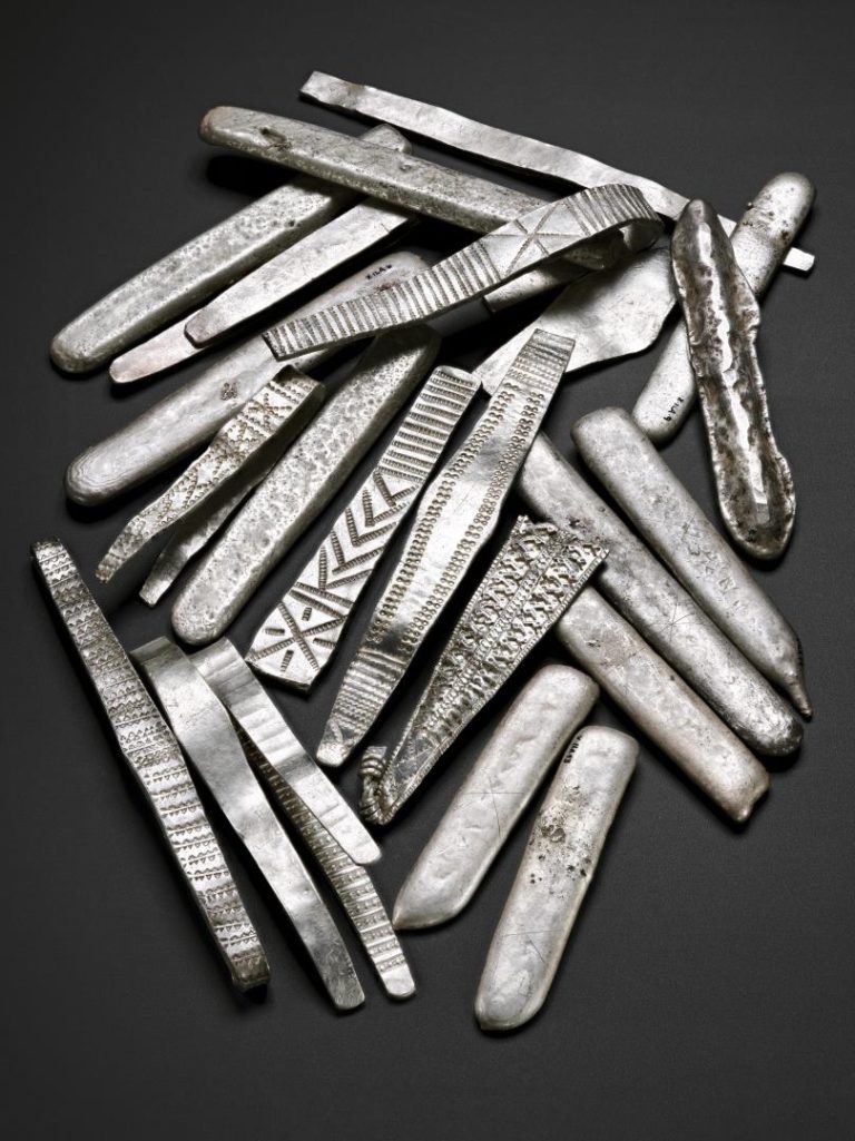
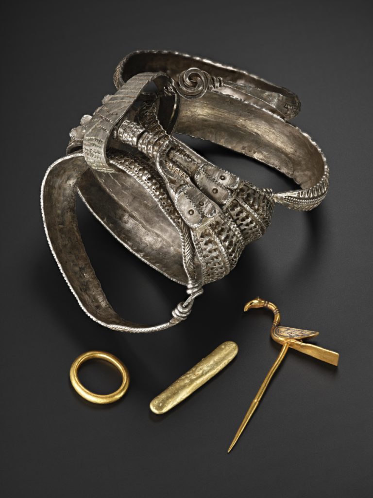
Galloway Hoard: Rare and unique Viking-age treasure goes on display at National Museum of Scotland
It was the day that an amateur metal-detecting enthusiast unearthed one of the largest discoveries of Viking treasure in Scotland.
In September , retired businessman Derek McLennan was scanning an area of church land in Dumfries and Galloway with two local ministers when he stumbled across more than 100 objects including solid gold jewellery, arm bands and silver ingots.
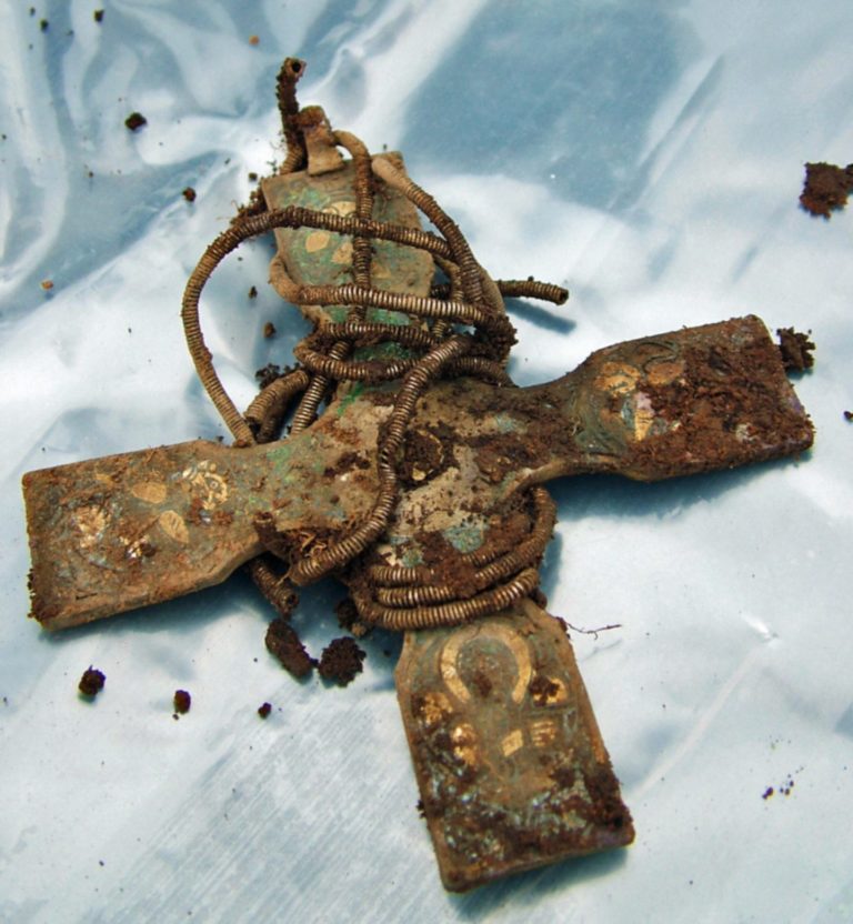
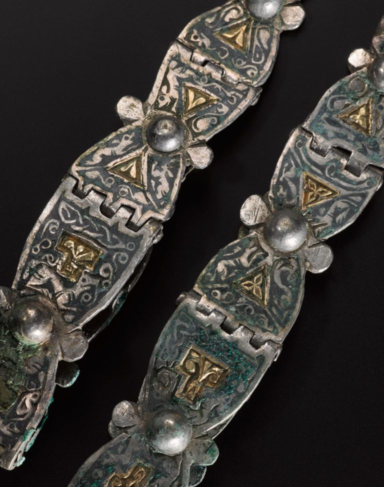
Pectoral cross from the Galloway Hoard before being cleaned
The artefacts, thought to have been buried between the mid-ninth and 10th century, included an early Christian cross made of solid silver, with unusual enamelled decorations.
At first, Derek failed to recognise the significance of his find.
However, to his amazement, the more he kept digging, the more he found.
After turning over what he thought was a silver spoon and wiping it with his thumb, he saw a saltire-type of design and knew instantly it was Viking.
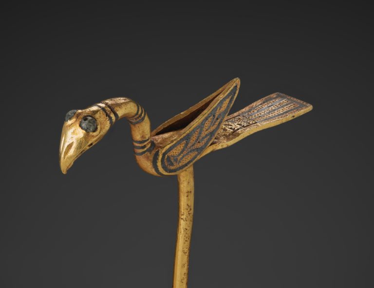
Conserved bird pin from the Galloway Hoard
“Then my senses exploded!” he revealed in an interview at the time, as further digging revealed a second layer of artefacts, including an intact Carolingian (western European) pot with its lid still in place.
In 2022, the treasure trove now known as the Galloway Hoard was acquired by National Museums Scotland for £1.98 million with the support of the National Heritage Memorial Fund, Art Fund and the Scottish Government as well as a major public fundraising campaign.
Since then, it has been undergoing extensive conservation and research at the National Museums Collection Centre in Edinburgh.
In 2022 the Scottish Government announced funding to enable National Museums Scotland to tour the Galloway Hoard to museums
Now, this internationally significant collection is going on public display at the National Museum of Scotland in Edinburgh for the first time, offering the chance to see intricate details hidden for over 1000 years, revealed by expert conservation, painstaking cleaning and cutting-edge research.
The new and free entry exhibition, Galloway Hoard: Viking-age Treasure, which opens on May 29, aims to transform visitors’ understanding of Scotland’s connections with the wider world during the Viking period, and to give a fascinating insight into archaeology in progress.
Amazing discovery and so much more
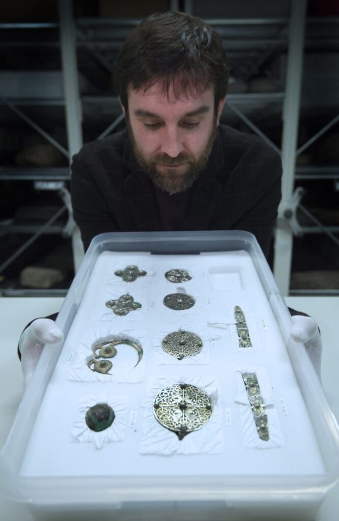
County Durham-raised professional archaeologist Dr Martin Goldberg, Senior Curator, Medieval Archaeology & History at National Museums Scotland, laughs that “diggers never find anything” when asked if he discovered anything of note during the 10 years he was a “jobbing archaeologist” in the early 2000s.
He’s delighted, however, to be working so closely with the Galloway Hoard which is the richest collection of rare and unique Viking-age objects ever found in Britain or Ireland.
Buried around 900 AD, as well as silver, gold and jewelled treasures, the hoard includes rarely surviving textiles including wool, linen and Scotland’s earliest examples of silk which raises intriguing questions about trade with Europe and Asia during the time the Vikings were known to be raiding, and settling, parts of Scotland.
“For me what’s amazing about the Galloway Hoard is it’s not just about that initial discovery – there were so many things in it there we’ve never seen before, and it had a very unusual preservation of organic materials,” he says.
A pot with its lid removed, which is amongst the Viking treasure in the Galloway Hoard
“What the exhibition is trying to show people is the ongoing process of discovery that we’re engaged in.
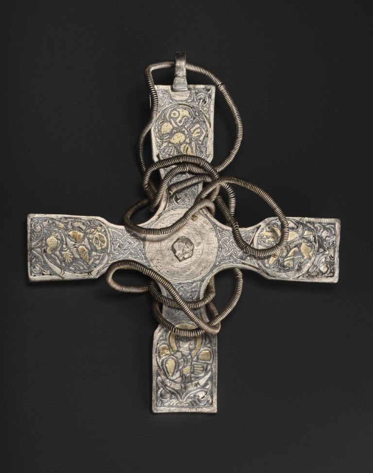
“There are things with the conservation process – the cleaning and the preserving of the objects – that are being revealed to us for the first time, and probably the big icon of that is this Anglo Saxon cross that we are using as the marketing piece for the exhibition.
“Sure enough the 50 hours of conservation time it took my colleague Mary Davis to clean the cross has revealed this really stunning Christian iconography on it.
Pectoral cross from the Galloway Hoard after being cleaned
“That’s one of the unusual items – it’s the type of thing you wouldn’t expect in a stereotypical Viking hoard and at every turn when you look through this material, there is always something unexpected.”
Buried in layers
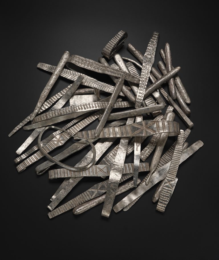
The exhibition shows how the hoard was buried in four distinct parcels.
The top layer was a parcel of silver bullion and a rare Anglo-Saxon cross, separated from a lower layer of three parts.
Silver bullion from the upper layer of the Galloway Hoard
The first of these was another parcel of silver bullion wrapped in leather and twice as big as the one above.
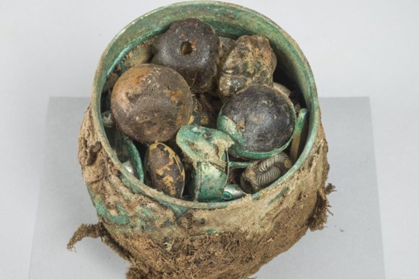
The second was a cluster of four elaborately decorated silver ‘ribbon’ arm-rings bound together and concealing in their midst a small wooden box containing three items of gold.
The third was a lidded, silver gilt vessel wrapped in layers of textile and packed full of carefully wrapped objects that appear to be have been curated like relics or heirlooms.
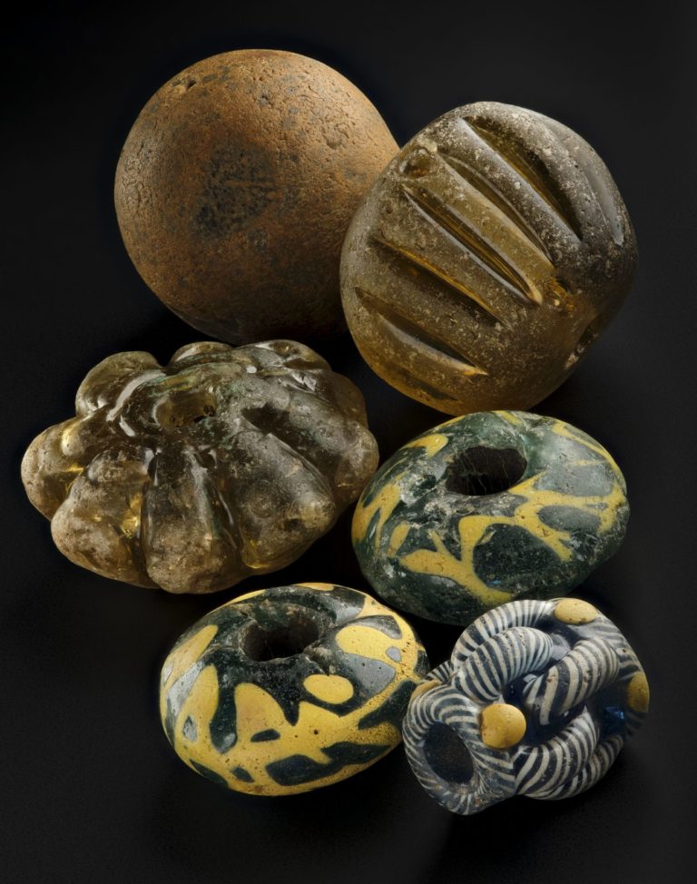
Glass beads, from the 10th-century treasure trove, known as the Galloway Hoard
They include beads, pendants, brooches, bracelets, an elaborate belt-set, a rock crystal jar and other curios, often strung or wrapped with silk.
Martin explains that discovering and decoding the secrets of the Galloway Hoard is a multi-layered process.
Conservation of the metal objects has revealed decorations, inscriptions and other details that were not previously visible.
Anglo-saxon metalwork from Galloway Hoard
Research into many aspects of the hoard continues and will take many years.
Some items are too fragile to be displayed, particularly those with rare textile survivals.
The exhibition is using AV and 3D reconstructions to enable visitors to understand these objects and the work that is being done with them.
Comparison with other collections and consultation with specialists around the world has enabled deeper understanding of the hoard.
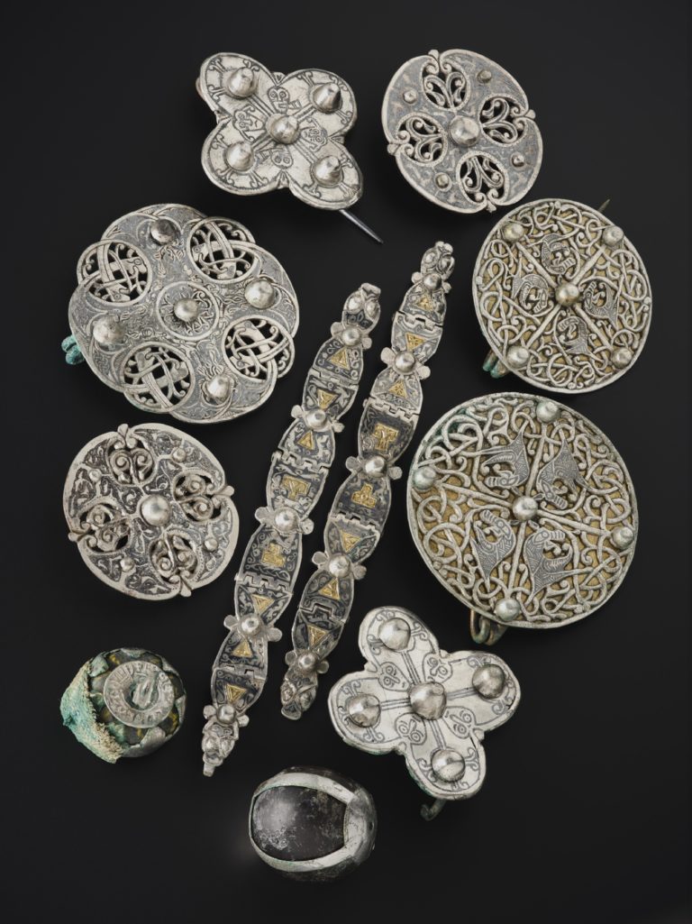
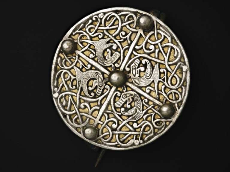
Disc brooch from the Galloway Hoard
Yet at the same time, it raises many unanswered questions.
For example, an Anglo-Saxon runic inscription on an arm-ring fragment has revealed the name ‘Egbert’, perhaps a person associated with the hoard’s burial.
However, the Old English name, rather than a Scandinavian one, causes experts to question simple stereotypes about the identities of those involved with the hoard’s accumulation and burial.
Preliminary studies
Scientific analysis is enabling greater precision about the date and composition of the material, which in turn offers clues to where the individual objects may have come from.
Four arm-rings and gold from the Galloway Hoard
A research programme funded by the Arts and Humanities Research Council, starting the Monday after the exhibition opens, aims to look into the origins of some of these materials.
Preliminary studies have already revealed incredible international connections with materials sourced from Ireland, England and Viking-age Scandinavia, as well as objects of some antiquity from ancient Rome, and others travelling thousands of miles from as far away as Central Asia.
The vessel in which the hoard was contained also appears to have originated somewhere in Central Asia.
Silver bullion from the lower layer of the Galloway Hoard
“The silver bullion is part of an economy that has grown around the Irish Sea in the 9th century,” says Martin.
“There’s a sudden influx of silver and some of that silver is coming from as far away again as Asia, the Islamic Caliphates.
“We know that that material is being made in the Irish Sea but we know that the silver is coming from elsewhere.
“Say for instance if you find amber, that has to come from the Baltic, or the silk that’s in the hoard – we know that has to travel somewhere from Asia.
Gold objects from the Galloway Hoard
“You get this picture of regional economy through the silver bullion.
“But then the other materials that are unusual for a Viking hoard, and particular to this hoard, are telling us about much wider connections.”
Who did the hoard belong to?
Martin says it would be “pure speculation” to suggest who the hoard belonged to or why it was buried.
However, there is evidence of there being a group of people involved with some older objects looking like heirlooms passed down through generations.
Dr Martin Goldberg
“You get this picture of regional economy through the silver bullion.
“But then the other materials that are unusual for a Viking hoard, and particular to this hoard, are telling us about much wider connections.”
“There are runic inscriptions on four arm-rings, and those runic inscriptions would normally tell us that they are names, they are identifiers of people,” he says.
“Then there’s another group of arm-rings that are all sort of knotted together almost like a contract, but there’s four of them.
“So there seems to be these signals in various parts of the hoard that we are looking at four owners at least for the bullion.”
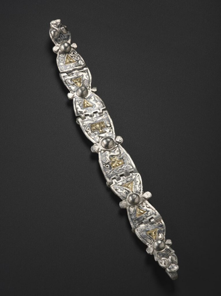
Multi-hinged strap from the Galloway Hoard
The Viking Age
Martin explains that the burial dates to the earliest part of the Viking age.
The first Viking attacks are recorded on Lindisfarne in 793 AD, and this hoard is probably buried 100 years after that around 900 AD.
For context, the first mention of the Gaelic kingdom of Alba is around 900 AD, while the first time that Alfred the Great’s descendants start talking about England as a political entity is when they are pushing back against the Vikings, and that’s also around 900 AD or certainly in the 10th century.
Martin says that while there isn’t a huge amount of material evidence of Viking activity in South West Scotland at this time, there is a lot of place name evidence all around the Irish Sea coasts where the seafaring Vikings raided, settled and then named settlements.
What a big find like the Galloway Hoard does is make archaeologists re-assess other evidence already linked to the area.
The Galloway Glens place name project, for example, is studying the interface between Brittonic, Anglo Saxon, Gaelic and Norse place names and trying to establish patterns left on the landscape.
Objects from the Viking Galloway Hoard
It’s a “real challenge” for Martin to pinpoint a stand-out item because the hoard contains so many new things.
From the discovery of more gold than any other Viking age hoard that survives from Britain or Ireland, to the 5kg of silver and the mystery of the vessel from somewhere in Central Asia, there’s plenty to fascinate.
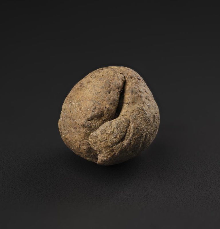
However, it’s two balls of dirt found right at the bottom of the vessel, nestled in amongst the silks and the gold and the rock crystal, that intrigue Martin most.
Ball of dirt from the Galloway Hoard
Normally they wouldn’t survive. They’d turn to dust, or if they got wet they would dissolve away.
But because the vessel had a lid on it and because the vessel was wrapped, they’ve been protected.
It also suggests the balls of dirt were curated – that somebody looked after them and somebody thought they were special enough to place in amongst all these treasures. The question is – why?
Stand-out item
“For me they stand out because they are so mundane,” says Martin.
“They are literally balls of dirt. You can see how they were formed as a kid would with Plasticine – like two sausages of dirt material being rolled into a ball about the size of a Malteser.
“But again my colleague Mary Davis who’s the conservator, she microscopically picked up traces of gold in the dirt and minute traces of bone. So you think, ‘right it’s not just any old dirt then!’
“It’s possible these were reliquary earth relics – balls of dirt rolled by people on pilgrimages to holy shrines then kept as sacred relics.”
It’s the solving of mysteries about the past that got Martin into archaeology in the first place, and he hopes visitors to the hoard, which he describes as an “incredible gift”, will be inspired by this ongoing process of discovery.
Pectoral cross from the Galloway Hoard after being cleaned
Well-Preserved Iron Age Butter Found At The Bottom Of Lake In Scotland
The replica crannog on Loch Tay, where the butter was found.
Now, the wooden butter dish remains one of the most evocative items left behind by Scotland’s ancient water dwellers who made their homes on Loch Tay.
The dish was recovered during earlier excavations on the loch where at least 17 crannogs, or Iron Age wooden houses, were once dotted up and down the water.
Built from alder with a life span of around 20 years, the structures simply collapsed into the loch once they had served their purpose, with an incredible array of objects taken with them.
Most Popular
The 2,500-year-old butter dish and the remains of the butter.
Among them was the dish which, remarkably, still carried traces of butter made by this Iron Age community.
Rich Hiden, the archaeologist at the Scottish Crannog Centre, said the item had helped to illuminate the everyday life of the crannog dwellers who farmed the surrounding land, and grew barley and ancient wheats such as spelt and emmer, and reared animals.
The crannogs were probably considered high-status sites which offered good security as well as easy access to trading routes along the Tay and into the North Sea.
Mr Hiden said conditions at the bottom of the loch had offered the perfect environment to preserve the butter and the dish.
He said: “Because of the fantastic anaerobic conditions, where there is very light, oxygen or bacteria to break down anything organic, you get this type of sealed environment.
“When they started excavating, they pulled out this square wooden dish, well around three-quarters of a square wooden dish, which had these really nice chisel marks on the sides as well as this grey stuff.”
Liped analysis on this matter found that it was dairy material, with experts believing it likely originated from a cow. Holes in the bottom of the wooden dish further suggest that it was used for the buttering process.
Cream would have been churned until thickened until it splits to form the buttermilk, with a woven cloth – possibly made from nettle fibres – placed in the dish with the clumps of cream and then further pushed through to separate the last of the liquid.
The butter then may have been turned into cheese by adding rennet, which naturally forms in a number of plants, including nettles.
Mr Hiden said: “This dish is so valuable in many ways. To be honest, we would expect people of this time to be eating dairy. In the early Iron Age, they had mastered the technology of smelting iron ore into to’s so mastering the technology of dairy we would expect.
“So while it may not surprise us that they are eating dairy, what is so important about this butter dish is that it helps us to identify what life was like in the crannogs and the skills and the tools that they had
“To me, that is archaeology at its finest. It is using the object itself to unravel the story. The best thing about this butter dish is that is so personal and offers us such a complete snapshot of what was happening here.
He added: “It is not just a piece of wood. You look at it and you start to extrapolate so much. If you start to pull one thread, you look at the tool marks and you see they were using very fine chisels to make this kind of object. They were probably making their own so that gives another aspect as to how life was here.”
It is believed that 20 people and animals lived in a crannog at any one time. Many trees were used to fashion the homes, with the Iron Age residents having a solid knowledge of trees with their houses thatched with reed and bracken.
Hazel was woven into panels to make walls and partitions.
Plans are underway to relocate the Scottish Crannog Centre to a bigger site at Dalerb, with three to four crannogs to be built in the water there.
12,000-year-old massive underground tunnels are real and stretch from Scotland to Turkey
Is it possible that ancient cultures were interconnected thousands of years ago? According to thousands of underground tunnels that stretch from North Scotland towards the Mediterranean the answer is a big yes.
While the reason behind these sophisticated tunnels remains a mystery, many experts believe that this huge 12,000-year-old network was built as a protection against predators and other dangers 12,000 years ago.
Some experts believe that these mysterious tunnels were used as modern-day highways, allowing the transition of people and connecting them to distant places across Europe.
In the book Secrets Of The Underground Door To An Ancient World (German title: Tore zur Unterwelt) German archaeologist Dr Heinrich Kush states that evidence of huge underground tunnels has been found under dozens of Neolithic settlements all over the European continent. These tremendous tunnels are often referred to as ancient highways.
According to Dr Kusch, the fact that many of these tunnels still exist today, after 12,000 years indicates that the tunnels must have been both complex and huge in size.
“Across Europe, there were thousands of them says Dr Kusch,” in Germany, we have discovered hundreds of meters of underground tunnels. In Austria, we have found hundreds more. These underground tunnels can be found everywhere across Europe and there are thousands of them.” Said the German archaeologist.
While some of the tunnels are relatively small- some of them measure over a meter in width, there are other tunnels that have been found with underground chambers and storage areas.
The fact that these tunnels have been found points towards incredible ancient ingenuity which is anything but what history books tells us today. Ancient mankind had the knowledge and tools to build complex structures over ten thousand years ago.
Evidence of that is the Pyramids of Bosnia in Europe and their incredible underground tunnels that go on for kilometres.
Dr Kusch states that ‘Across Europe, there were thousands of these tunnels – from the north in Scotland down to the Mediterranean.
They are interspersed with nooks, at some places it’s larger and there is seating, or storage chambers and rooms. They do not all link up but taken together it is a massive underground network.’
Cappadocia in Turkey is another incredible example. The underground city of Derinkuyu is another piece of evidence that points towards the perfection and long-lost construction methods of our ancestors.
The underground city of Derinkuyu is perhaps one of the greatest achievements in underground construction together with the huge network of tunnels.
The geological features of the stone from Derinkuyu is something that is very important; it is very soft. Thus, the ancient builders of Derinkuyu had to be very careful when building these underground chambers providing enough pillar strength to support the floors above; if this was not achieved, the city would have collapsed, but so far, archaeologists have not found evidence of any “cave-ins” at Derinkuyu.
Other ancient monuments such as Gobekli Tepe are more pieces of crucial evidence that point towards incredible skills and knowledge by people who inhabited our planet over ten thousand years ago.
According to Dr Kusch, chapels were often built at the entrances to the underground tunnels because the Church were afraid of the heathen legacy the tunnels might have represented, and like many other things, the church wanted to make sure word about the tunnels was kept as a secret.
In some of the tunnels, writings have been discovered which refer to these underground tunnels as gateways to the underworld.